Via Scoop.it – Geography Education
Today, we want to show you another wonderful 3D illusion which is installed in front of the steps of Paris’s city hall. Geographically inspired public art that is also a massive optical illusion makes me happy on so many levels.
Via www.boredpanda.com

Via Scoop.it – Geography Education
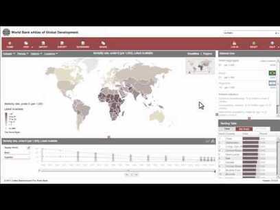
“The World Bank eAtlas of Global Development maps and graphs more than 175 thematically organized indicators for over 200 countries, letting you visualize and compare progress on the most important development challenges facing our world. Most indicators cover several decades, so you can see, for example, how ‘life expectancy at birth’ has improved from 1960 up through the latest year.” This tool should greatly enhance student projects as they will add more data, and see bigger patterns.
Via www.youtube.com
Via Scoop.it – Geography Education
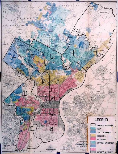
These are great images that shows the can build historical and geographical empathy for those that were discriminated against during the era of redlining. These maps from the Home Owners’ Loan Corporation mapped and shaped regions of urban disinvestment (but the maps were NOT widely circulated). This example of redlining in 1936 Philadelphia, links you to primary source documents if you click on the map. The documents are reports on the property values, resident demographics and descriptions of the residential zones. For more, visit the Philadelphia redlining research project.
Via cml.upenn.edu
Via Scoop.it – Geography Education
Ambitious development plans for the 2016 Summer Olympics, as well as the 2014 soccer World Cup, involve large-scale evictions from numerous slums, whose residents are refusing to leave. The urban revitalization issues in Rio de Janiero are not new, but they will intensify in global importance (or at least coverage) as the time for the World Cup and Olympics approaches. What are the aesthetics and economics behind revitalization? What are the social issues that should be addressed?
Via www.nytimes.com

Via Scoop.it – Geography Education
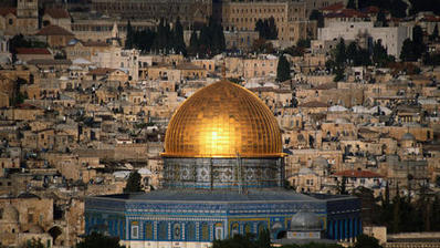
Read Religious architecture of Islam for travel tips, advice, news and articles from all around the world by Lonely Planet… This is an excellent article that can be used in a thematic class for analyzing religion, the human landscape, the urban environment and cultural iconography. For a regional geography class, this show great images from Indonesia, Spain, Egypt, Syria and Israel/Palestine.
Via www.lonelyplanet.com
Welcome to Geographyeducation.org. I was never planning to do this, but after more than 45,000 hits on my first site, I need to restructure my digital online resources (and I’m so glad to do so because that means you’ve been finding value in this work). As you may know, I’ve been posting what I find to be relevant news stories, videos, articles and other digital resources on Twitter as @APHumanGeog, Google+ and Facebook for about 7 months now and was pleased to get a following that enjoyed the content.
However, readers wanted something archived so I created my scoop.it page www.scoop.it/t/geography-education to fulfill that purpose. After now having about 30 pages worth of content, searching through them can be unwieldy and the the searchable ‘tags’ are not foolproof (I individually create the tags, so it’s definitely not foolproof). Several readers suggested a more permanent way to archive these suggestions in a more thematic manner and who am I to argue with a good suggestion? and that is the genesis of this site.
In terms of aesthetics, it is far from a finished project. In fact, the “Regional” tab is the only operational tab and even that is only piecemeal at the moment. I was half-tempted to delay launching the site until is was more operational, but I wanted user feedback to drive how I structure the site to make it suited to my readers needs. I will continue posting primarily on my various scoop.it pages, but here is where I will thematically and regionally organize that content. I will let you know as more developments arise and hope that your comments become part of the developmental process.
A message from the National Geographic Society that is worth passing on:
Did you know? Only 20 U.S. states require a geography class in middle or high school, while many countries (like Switzerland, France, Norway, and Romania) require geography every year until high school graduation. Maybe that’s why 88% of 18-24 year old Americans can’t find Afghanistan on a map of Asia!
- Geography is much more than knowing where things are located, but without basic geographic knowledge it’s impossible to make informed decisions in our personal, professional, and civic lives.
- Right now, geography is named as a “core academic subject” but unlike all the other core academic subjects, including history, civics, economics, foreign languages and the arts, there is no dedicated federal funding stream to advance geography education.
We need to let Congress know that learning geography is important. Join the public campaign in support of the Teaching Geography is Fundamental Act. Go to sufgCampusChallenge.org to find out how you can Speak Up For Geography.
Many thanks for your support!
This is a my first attempt to see what will work for this site. My first site on scoop.it! is still active, but many readers were hoping to have a way where the resources that I have recommended could be thematically organized. I’ll continue putting the latest sources on the Geography Education scoop.it site, but will thematically and regionally organize them here. Hopefully that will function as a daily newspaper or weekly magazine for browsing the latest geographic materials online, while this site can be a storehouse for planning lessons with a specific topic in mind.


