
A new project from U.S. News & World Report has an ambitious goal: Ranking the world.
Source: www.washingtonpost.com
I’m not endorsing the ratings or the methodology behind the ratings, but they are certainly fodder for discussion.
A new project from U.S. News & World Report has an ambitious goal: Ranking the world.
Source: www.washingtonpost.com
I’m not endorsing the ratings or the methodology behind the ratings, but they are certainly fodder for discussion.
Early meteorology helped farmers predict yield, transforming the agricultural industry.
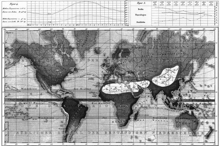
Complaining over the weather is not new, but the science of studying the weather, and its effects on business, is fairly recent. Around [1920], economists were also starting to use statistical methods to predict yield. Although cotton’s price, as shown on the New York Cotton Exchange, fluctuated daily, a “well-known American economist” discovered that he could make the most accurate total yield predictions—more accurate than those of the government crop reports—by analyzing the average weather conditions from May to August. It was now possible to predict when the crops would have a bumper year or a poor one.
Tags: physical, weather and climate, food production, agribusiness, agriculture.
Source: daily.jstor.org
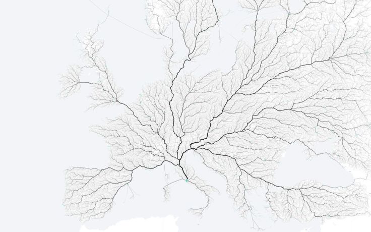
“As the saying goes, ‘All roads lead to Rome.’ Folks at the moovel lab were curious about how true this statement is, so they tested it out. They laid a grid on top of Europe, and then algorithmically found a route from each cell in the grid to Rome, resulting in about half a million routes total. Yep, there seems to be a way from Rome from every point.”
Tags: fluvial, mobility, transportation, mapping.
Source: flowingdata.com
“From icebergs and Inuit legends to polar bear organs and exploration disasters, 50 questions to truly test your northern knowledge.”
Source: www.canadiangeographic.ca
These are 50 HARD questions (any student not from Canada that gets over 50% right should pat themselves on the back).
“Happy New Year, and welcome to NCGE’s second century! For those of you who joined us for our centennial celebration, you know that the National Council for Geographic Education is moving forward in bold new ways. Today, as I sit pondering an impending winter storm warning, I invite you all to consider spending the end of July 2016 in Tampa, Florida, with NCGE. The call for proposals launched last week, and will remain open until March 1, 2016. (You can learn more about submitting a proposal here). I can’t think of a better way to spend the end of my summer break than by spending it with my geography friends and family. The conference promises to be another spectacular one. We have several themes suggested for you to consider presenting content and practices, including AP Human Geography, the Centennial of the National Parks Service, and coastal geography.”
Source: ncge.org
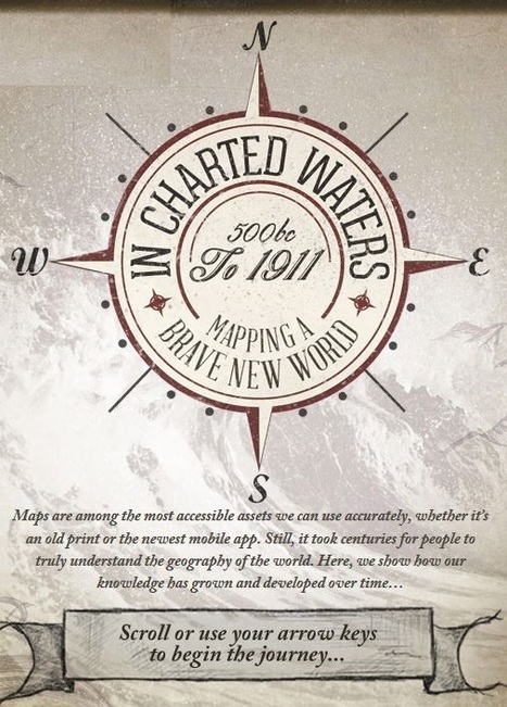
“Use our interactive In Charted Waters tool which shows information & visuals on how our knowledge of the world map has evolved.”
Source: www.thefwa.com
This interactive map/timeline takes users (shared before but the URL has been updated here) around the world through the major events representing the expansion of human knowledge. Admittedly, this is represents knowledge from a Eurocentric perspective, but that is somewhat appropriate in this instance since that was the largest store of spatial knowledge as this global information coalesced. Users can visualize the coordination of absolute space and realize the actions undertaken that shifted geography from its predecessor, cosmology. Each achievement came through intensive exploration and the detailed mapping of those endeavors.
Tags: historical, mapping, cartography, Unit 1 GeoPrinciples.
“Ok…we’ll admit it. Jerry Mandering isn’t a real political candidate. We created this video to highlight the absurdity of the process behind having elected officials draw their own lines to their advantage – a manipulative practice known as ‘gerrymandering.’ Public officials like Del. Jerry Mandering wish you wouldn’t worry about the fact that he can pick and choose his own voters, but you can let your legislators know that you support a non-partisan effort for fairer, more competitive elections.”
Source: www.youtube.com
This spoof video was highlighted in a Washington Post article, and most parodies, it wouldn’t be funny if there weren’t so much truth in it.
Tags: political, gerrymandering, mapping, unit 4 political.
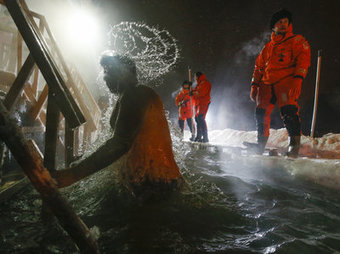
“Thousands of members of the Russian Orthodox Church marked Epiphany in January with a dip in freezing waters blessed by a cleric. Epiphany is a celebration of the baptism of Jesus Christ and the revelation of God as a human being in his form. Much like a baptism, the icy plunge is considered a purifying act of faith.”
Source: www.npr.org
Some of the photography and photo galleries of this cultural event are breathtaking–literally for those taking the plunge. Russians cut the ice in the shape of a cross and bath in water that is blessed and considered holy as explained in this NPR podcast. This religious tradition is particularly well-suited to the environmental conditions of the religious adherents (since the extreme climate plays a critical role in the activity). Part of the practice involves sacrifice; the colder the swim, the greater the manifestation of religious devotion.
Tags: Russia, religion, Christianity, culture.

“Being a fluent speaker of English and Saulteaux, I have to say that I view the world in two different ways. I have two different attitudes and even two different personalities, depending on which language I use…English offers me one way to order information and cope with reality, one set of attitudes and behavioral styles, and Saulteaux offers me a different way. When I switch languages, I also move from one constellation of attitudes and thought patterns to another.”
Source: www.sicc.sk.ca
This passage was written by Margaret Cote, a member of the Saulteaux people, who are part of the larger Ojibwa or Chippewa Native American tribe.
Questions to Ponder: How does language shape cultural attitudes, traits, and customs? How does language shape a speakers world view and personality? How does language influence how a speaker may feel about place?


