Search

GEOGRAPHY EDUCATION

Supporting geography educators everywhere with current digital resources.

Category

Uncategorized

India heatwave kills 800 as capital’s roads melt

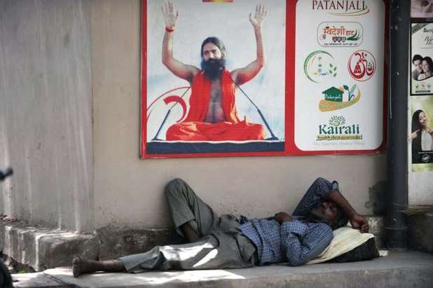
“At least 800 people have died in a major heatwave that has swept across India, melting roads in New Delhi as temperatures neared 50 degrees Celsius (122 Fahrenheit).  Hospitals are on alert to treat victims of heatstroke and authorities advised people to stay indoors with no end in sight to the searing conditions.  In the worst-hit state of Andhra Pradesh, in the south, 551 people have died in the past week as temperatures hit 47 degrees Celsius on Monday.” 

Tags: physical, weather and climate, India, South Asia.

Source: www.msn.com

This article on MSN and this NPR podcast remind me about how extremes can create chaos.  While in Texas, the flooding has ravaged much of the state.  Weather from other places is never news unless it is so extreme that it becomes a crisis.   

The case for engineering our food

Pamela Ronald studies the genes that make plants more resistant to disease and stress. In an eye-opening talk, she describes her decade-long quest to help create a variety of rice that can survive prolonged flooding. She shows how the genetic improvement of seeds saved the Hawaiian papaya crop in the 1950s — and makes the case that it may simply be the most effective way to enhance food security for our planet’s growing population.

Tags: GMOstechnology, agriculture.

Source: www.youtube.com

HDI over time in Central America

“Explore public data through Google’s visualization tools.” 

Source: www.google.com

One exercise that I do in many of my classes is based on this data and and outline map.  I have the students map out the Human Development Index data for Central America (full global dataset here) on an outline map of the region.   

Questions to Ponder: How might we be able to infer about migration within the region?  Foreign investment?  Political stability? 

Tags: Middle America, development, statistics, economic, mapping.

3 easy ways to tell if a viral photo is bogus

“Many people posting it wrote that the photo was taken during the recent Nepal earthquakes, and that it depicts ‘a brother protecting his sister.’ Pretty heartwarming, right? It’s the exact sort of thing your aunt would share on Facebook. A perfectly clear, resonant message about survival and empathy and inequality, all that good stuff.  There’s only one problem: That picture is fake.”

Source: www.dailydot.com

I’ve added this article to my list of resources to help geography students to be able to assess the validity of online resources. 

Tags: social media.

The Precision Agriculture Revolution

“Thousands of years ago, agriculture began as a highly site-specific activity. The first farmers were gardeners who nurtured individual plants, and they sought out the microclimates and patches of soil that favored those plants. But as farmers acquired scientific knowledge and mechanical expertise, they enlarged their plots, using standardized approaches—plowing the soil, spreading animal manure as fertilizer, rotating the crops from year to year—to boost crop yields. Over the years, they developed better methods of preparing the soil and protecting plants from insects and, eventually, machines to reduce the labor required. Starting in the nineteenth century, scientists invented chemical pesticides and used newly discovered genetic principles to select for more productive plants. Even though these methods maximized overall productivity, they led some areas within fields to underperform. Nonetheless, yields rose to once-unimaginable levels: for some crops, they increased tenfold from the nineteenth century to the present.  

Today, however, the trend toward ever more uniform practices is starting to reverse, thanks to what is known as ‘precision agriculture.’ Taking advantage of information technology, farmers can now collect precise data about their fields and use that knowledge to customize how they cultivate each square foot.”

Tags: technologyfood production, agriculture, agribusiness, spatial, GPS.

Source: www.foreignaffairs.com

On the trail of Myanmar’s Rohingya migrants

Jonah Fisher has been to Rakhine state in Myanmar to meet Rohingya migrants who are being forced to return home – but at a cost.

Source: www.bbc.com

The Rohingya that are in the news lately are refugees on boats that everyone agrees that SOMEONE should help, but that no country in Southeast Asia wants to bring in. 

Tags: migration, political, refugees, Burma, Southeast Asia.

How Suburban Are Big American Cities?

“What, exactly, is a city? Technically, cities are legal designations that, under state laws, have specific public powers and functions. But many of the largest American cities — especially in the South and West — don’t feel like cities, at least not in the high-rise-and-subways, ‘Sesame Street’ sense. Large swaths of many big cities are residential neighborhoods of single-family homes, as car-dependent as any suburb.

Cities like Austin and Fort Worth in Texas and Charlotte, North Carolina, are big and growing quickly, but largely suburban. According to Census Bureau data released Thursday, the population of the country’s biggest cities (the 34 with at least 500,000 residents) grew 0.99 percent in 2014 — versus 0.88 percent for all metropolitan areas and 0.75 percent for the U.S. overall. But city growth isn’t the same as urban growth. Three cities of the largest 10 are more suburban than urban, based on our analysis of how people describe the neighborhoods where they live.”

Tagsurban, suburbs, housingsprawlplanning, density,.

Source: fivethirtyeight.com

With Booze and Tobacco Taboo, Utah Leads Nation in Candy Eating

“More than 60 percent of Utah’s residents are Mormons, who typically abstain from alcohol, caffeine and tobacco. With those vices frowned upon, candy is an acceptable treat.  Hispanics like Hershey’s Cookies ’n Creme bars in disproportionate numbers, and Minnesotan buy six-packs of Hershey bars at higher rates than any other Americans, particularly in the summer (think s’mores).”

Tags: food distribution, place, food, religion, ethnicity.

Source: www.bloomberg.com

This report brings up three interesting tidbits about candy consumption in the United States, but this is also a good article to discuss how businesses should take geography and demographic statistics seriously when crafting their marketing strategies.  

Create a free website or blog at WordPress.com.

Up ↑