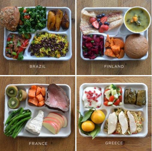
Eating at the school cafeteria could’ve been amazing if you grew up almost anywhere but the U.S.
Tags: agriculture, food distribution.
Source: www.fastcoexist.com
Eating at the school cafeteria could’ve been amazing if you grew up almost anywhere but the U.S.
Tags: agriculture, food distribution.
Source: www.fastcoexist.com
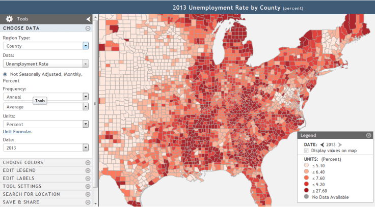
Creating and Analyzing a Binary Map: This online activity demonstrates how easy it is to master key functions in GeoFRED.
Source: www.stlouisfed.org
Last month I wrote an article about how to use GeoFRED for the National Geographic Education blog. Since then, GeoFRED was produced this lesson plan that will walk students through the basics of how to use the site and introductory mapping skills.
Tags: development, statistics, economic, mapping.
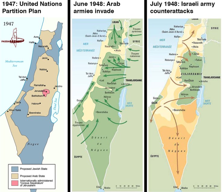
Yes, one of the questions is “Why are Israelis and Palestinians fighting?”
Source: www.vox.com
There is no need to be embarrassed, since we all need to start somewhere. This 2014 article provides some helpful context for students who don’t know what’s going on.
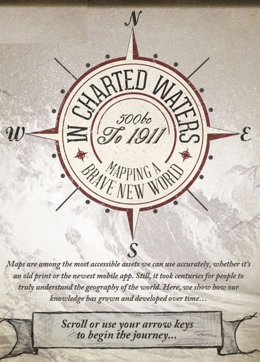
Use our interactive In Charted Waters tool which shows information & visuals on how our knowledge of the world map has evolved.
Source: www.msccruises.co.uk
This interactive map/timeline takes users around the world through the major events representing the expansion of human knowledge. Admittedly, this is represents knowledge from a Eurocentric perspective, but that is somewhat appropriate in this instance since that was the largest store of spatial knowledge as this global information coalesced. Users can visualize the coordination of absolute space and realize the actions undertaken that shifted geography from its predecessor, cosmology. Each achievement cam through intensive exploration and the detailed mapping of those endeavors.
Tags: historical, mapping, cartography, Unit 1 GeoPrinciples.

Robert Peston crunches the numbers as finance ministers meet for vital loan talks.
Source: soundcloud.com
This audio clip shows how the Greek economic crisis is an issue on the national, regional, and global scales. This BBC video and article also provide some nice context, asking the question, what would happen in Greece quits the Euro?
Tags: Greece, Europe, supranationalism, currency, economic, podcast.
As stated in this NPR article: “The video shows satellite tracking of routes superimposed over Google Earth. It focuses on some of the main choke points for international shipping, such as the Strait of Malacca on the southern tip of Malaysia, Suez Canal, the Strait of Gibraltar and Panama Canal. It’s a good reminder that about 90 percent of all the goods traded globally spend at least some of their transit time on a ship.”
Tags: transportation, globalization, diffusion, industry, economic, mapping, video, visualization.
Source: www.youtube.com
Geographic data can be so beautiful…you’ve got to watch this.
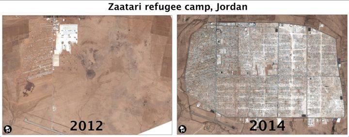
Stunning images taken from space put the world’s crises into context.
U.N. satellite imagery has tracked the evolution of the camp since its creation. The exponential growth is remarkable. The refugee camp is rapidly taking the shape of a real city — structured, planned and even separated into neighborhoods and subject to gentrification.
Tags: refugees, migration, conflict, political, war, squatter, urban, unit 7 cities, remote sensing, geospatial.
Source: www.washingtonpost.com

The scientific discoveries that were made with no thought of making money often turn out to be the most profound science, and, ironically, often lead to a gold mine.
The dumbest question you can ask a scientist—or any other creator, inventor, or discoverer—about his or her work is, “What’s the economic value?” The mistake at the heart of the dumbest question is this: confusing unknowable value with no value. History shows that basic science brings the greatest economic value of all—Hertz and Dobson are two of many examples.
Source: www.thedailybeast.com

Canada is a massive country, yet it has one of the lowest population densities in the world. Despite this, Canadians have made a wide impact on their land, much of it visible from aerial and satellite photography. Hydroelectric facilities, roads, mines, farms, ports, resource exploration, logging, canals, cities, and towns have altered much of the landscape over the years.
Source: www.theatlantic.com
This is a great set of images showing the human impact on the environment, with a special nod to our neighbors for the north. These images have an artistic beauty and I hope every geographer maintains a sense of wonder at the details and beauty of the Earth.
Tags: Canada, images, art, remote sensing, land use, landscape.


