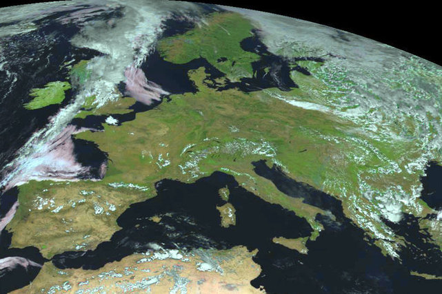
Europe, as both a place and a concept, has changed dramatically in its centuries of history.
Source: www.vox.com
Europe, as both a place and a concept, has changed dramatically in its centuries of history.
Source: www.vox.com
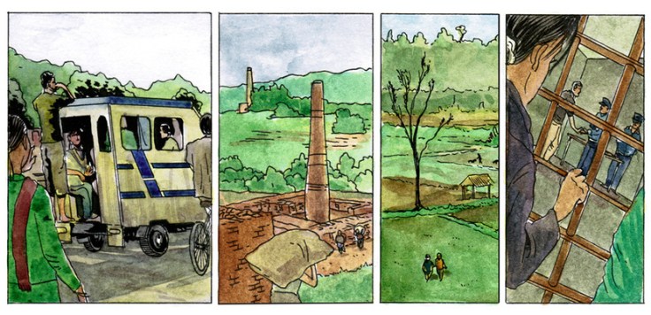
Laxmi’s story of being kidnapped and trafficked in Nepal is not an isolated case but, as this graphical account shows, things are not always what they seem.
Source: www.bbc.co.uk
Teaching about human trafficking and child slavery can be very disconcerting and uncomfortable. How much of the details regarding these horrific situations is age-appropriate and suitable for the classroom? The BBC is reporting on events with sensitive stories to both give a human face to the story, while protecting the identity of under-aged victims (to read about the production of this comic, read Drawing the News.) I encourage you to use your own discretion, but I find this comicbook format an accessible, informative and tasteful way to teach about human trafficking in South Asia to minors. It is a powerful way to teach about some hard (but important) aspects of globalization and economics.
As geographer Shaunna Barnhart says concerning this comic, “It moves from trafficking to child labor to pressures for migration for wage labor and the resulting injustices that occur. There’s differential access to education, gender inequality, land, jobs, and monetary resources that leads to inter- and intra-country trafficking of the vulnerable. In the search for improved quality of life, individuals become part of a global flow of indentured servitude which serves to exploit their vulnerabilities and exacerbate inequalities and injustice. Nepali children ‘paid’ in food and cell phones that play Hindi music in ‘exchange’ for work in textile factories – cell phones that are themselves a nexus of global resource chains and textiles which in turn enter a global market – colliding at the site of child labor which remains largely hidden and ignored by those in the Global North who may benefit from such labor.”
Tags: Nepal, labor, industry, economic, poverty, globalization, India.
“Various ecological, political and economic perspectives on habitat fragmentation from the West Wing: season 1, episode 5.”
Source: www.youtube.com
Our modern society depends on greater connectivity between places. Regionalized economies, politics and transportation networks are increasingly integrated with far-flung places now more than ever before. Our biosphere and natural environments are exceptions to this pattern. Wilderness areas are ‘islands’ in an ocean of human controlled environments. We create transportation linkages that unite people economies and cities, but separate herds from their extended habitat.
We’ve all seen road kill on major highways. Species like deer, elk, and grizzly bears and other large-bodied animals need a wide range for numerous ecological reasons. These bridges are an attempt to ameliorate some of the problems that our roads pose for the non-human species that still call Earth home. From a purely economic standpoint, many argue that these bridges save society money given the accidents and property damage that can be avoided.
Just for fun: This is a hilarious/painful video of a woman who clearly doesn’t understand these principles.
Tags: biogeography, transportation, environment, land use, sustainability, environment adapt.

After compiling an inventory of 3,959 lynching victims in 12 Southern states from 1877 to 1950, the Equal Justice Initiative wants to erect markers and memorials on certain sites.
Tags: race, conflict, racism, historical, the South, landscape.
Source: www.nytimes.com
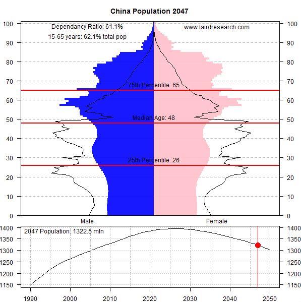
“The International Database at the US Census Bureau [provides] population estimates broken down by country, age and year for essentially every country. [With this data we can track] shifts in population makeup over time. I’ve created a few interesting graphs to show the expected shifts over the next 35 years, including the dependency ratio.”
Source: lairdresearch.com
This article has some excellent animated graphs and population pyramids to show some of the demographic changes that countries will be experiencing from now until 2050. These animated GIFs are perfect teaching images.
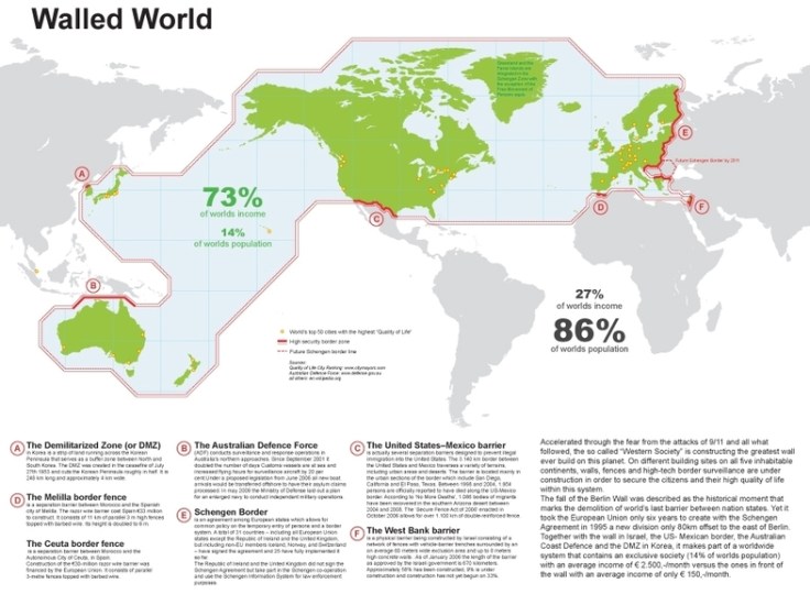
Accelerated through the fear from the attacks of 9/11 and all what followed, the so called ‘Western Society’ is constructing the greatest wall ever build on this planet. On different building sites on all five inhabitable continents, walls, fences and high-tech border surveillance are under construction in order to secure the citizens and their high quality of life within this system. The fall of the Berlin Wall was described as the historical moment that marks the demolition of world’s last barrier between nation states. Yet it took the European Union only six years to create with the Schengen Agreement in 1995 a new division only 80km offset to the east of Berlin.
Source: td-architects.eu
This map shows that hi-tech political surveillance of borders is highly correlated with the core areas of the global economy and some of the most attractive immigrant destinations.
Questions to Ponder: What else do you see in this map? What does this say about the world order? Are there patterns that this map reveals/conceals?
Tags: conflict, economic, political, geopolitics, migration, map.
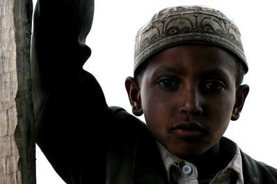
“I am torn about how to teach these two ideas about cultures and societies all around the world:
These points may seem like a contradiction, but when put into proper context they teach important truths about culture.”
Source: blog.education.nationalgeographic.com
I’ve posted several resources here about some of the intriguing cultural interactions in the Middle East stemming from globalization. I thought there was some excellent public dialog after the Charlie Hebdo shooting, but I was disheartened by some of prejudiced responses that I’ve heard since then–that inspired me to pull some of them together for this article I wrote for National Geographic Education.
Tags: National Geographic, religion, culture, Islam, globalization, popular culture, unit 3 culture.
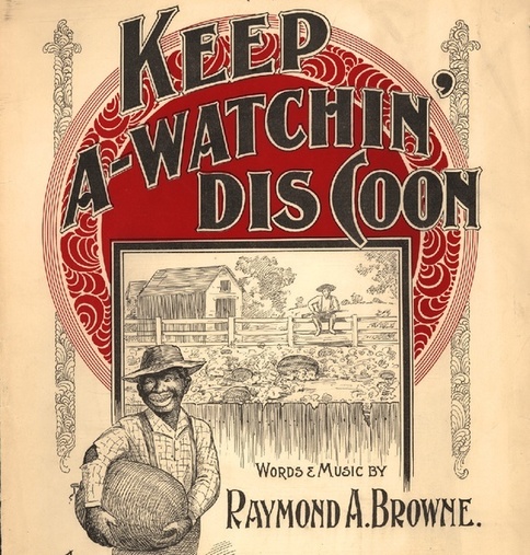
Before its subversion in the Jim Crow era, the fruit symbolized black self-sufficiency.
The stereotype that African Americans are excessively fond of watermelon emerged for a specific historical reason and served a specific political purpose. The trope came into full force when slaves won their emancipation during the Civil War. Free black people grew, ate, and sold watermelons, and in doing so made the fruit a symbol of their freedom. Southern whites, threatened by blacks’ newfound freedom, responded by making the fruit a symbol of black people’s perceived uncleanliness, laziness, childishness, and unwanted public presence. This racist trope then exploded in American popular culture, becoming so pervasive that its historical origin became obscure.”
Tags: culture, racism, historical.
Source: www.theatlantic.com
“Stratfor Military Analysts Paul Floyd and Sim Tack discuss how Russia’s strategy will maintain options as violence in eastern Ukraine continues.”
Tags: Ukraine, conflict, geopolitics, political.
Source: www.youtube.com




