Search

GEOGRAPHY EDUCATION

Supporting geography educators everywhere with current digital resources.

Imaginary Geographies

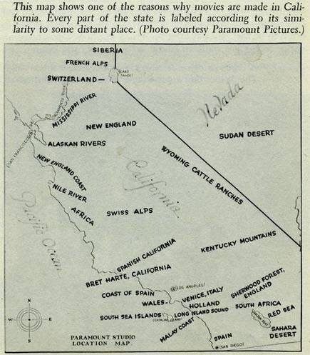
This fabulous 1927 map shows some of the key reasons why the movie industry flourished in Los Angeles–California’s physical geography is incredibly diverse. As the industry was emerging in the first half of the 20th century, they didn’t have massive budgets to travel the world to give their locations a great degree of geographic accuracy it their set locations. Southern California was the ideal home base for a wide range of locations that could physically approximate so many environments and ecosystems. This cost saving strategy had more than economic ramifications; this strategy reinforced many spatial (and cultural) stereotypes in the movies that powerfully influenced how people conceptualized what these places were like. These geographies of cinematic imagination, created for economic purposes, shape our regional perceptions.

Tags: place, California, landscape, popular cultureindustry.

Source: geographyeducation.org

Australia to Zimbabwe

“A Romp Around the World to 24 Countries.  The perfect gift for adventurers young and old – this book is a whirlwind exploration of world cultures!”

Source: www.australiatozimbabwe.com

I’ve received an advance copy of Australia to Zimbabwe and it is a delightful book that appeals to all ages (everyone in my house ate it up). Carefully layered so that readers can customize the experience to fit their interests, time, and goals, this treasure trove just begs the reader to keep exploring as they flip through its pages. Australia to Zimbabwe presents facts in a context that enlivens learning about the people and places of the world and heightens the reader’s curiosity. With the online supplemental materials, this book brings to life the sights, sounds, and smells of far-away places.  Teachers, librarians, and parents alike should all be excited to get their hands on this book when it comes out November 17th.


Tagseducation, K12geography education, book reviews.

China’s one-child policy and the lessons for America

Let’s review exactly what population has to do with economic growth

Source: theweek.com

The repeal of China’s one-child policy has many exploring the linkages between population statistics and economic development.  This is a good article that tries to show the lessons learned in China with the one-child policy and apply them to the United States economic context.  Additionally, this animated map shows the rise in urbanization in China.    


TagsChina, population, industry, development, statistics, economic.

The Fastest Growing Economies

See how the world’s largest and fastest growing economies change over time.

Source: money.cnn.com

This interactive is simple but conveys some very powerful data.  Above is a still shot of 2014’s fastest growing economies (you can also view the largest overall economies).  Another telling statistical ranking is the UN’s Human Development Index; explore more global data on Google’s Public Data


Tags: economic, visualizationstatisticsdevelopment, google.

Are you ignorant about the world?

The world is spinning so fast that it can be hard to keep track of everything going on. And most of us aren’t doing a good job of it, writes Hans Rosling.

Source: edition.cnn.com

Our preconceived notions of places, as well as some of the dominant narratives about regions, can cloud our understanding about the world today.  This article (with the embedded video) is a good introduction to the Ignorance Project which shows how personal bias, outdated world views and news bias that makes combating global ignorance difficult. 


Tags: media, models, gapminderdevelopment, perspective.

The Trans-Pacific Partnership Explained

“Stratfor Vice President of East Asia Analysis Rodger Baker talks about the economic and political aspects of the Trans-Pacific Partnership agreement.” http://arcg.is/1IeK3dT 

Source: www.youtube.com

This is a very politically contentious partnership and would reshape economic geographies and even regions of the world.  From the 1500’s to the 1980’s, the Atlantic trade had the greatest volume of world trade, but the Pacific has surged past, and is showing no signs of being supplanted any time soon.  This Stratfor video is a quick introduction to the economics and politics of the TPP. 

Tagsindustry, development, economic.

Daylight Saving Time Explained

Source: www.youtube.com

If you haven’t discovered CGP Grey yet, his YouTube channel is a veritable fountain of geographic tidbits.  Day Light Savings (whether you agree with it or not) has to do with fundamental Earth-Sun relationships and have some corresponding spatial patterns of who does or does not follow it.  The tag below links to my archive of his many geographically related videos.   


Tags: CGP Grey.

Russia and the Curse of Geography

Want to understand why Putin does what he does? Look at a map.

As things stand, Putin, like Russian leaders before him, likely feels he has no choice but to at least try to control the flatlands to Russia’s west. So it is with landscapes around the world—their physical features imprison political leaders, constraining their choices and room for maneuver. These rules of geography are especially clear in Russia, where power is hard to defend, and where for centuries leaders have compensated by pushing outward.

Source: www.theatlantic.com

Calling this environmental determinism might be a stretch but so is some of the vocabulary (I take it with a grain of salt because the analysis is sound).  This article though certainly puts Russia’s physical geography at the forefront of the geopolitical analysis of Russia’s move’s in both Syria and Ukraine.  Their strategic interests become much more comprehensible in light of their geographic challenges

Tags: UkraineRussia, geopoliticspolitical.

How Modern Cartographers Marry Math and Art

“Old maps get a lot of love, and with good reason—with their sea monsters and sheer craftsmanship, they can transport us through both space and time. But although they lack fold-mark furrows, there’s something to be said for new maps, too. Leafing through Mind the Map, a stunning new book from Gestalten, it’s hard not to think we’re living in the middle of a map renaissance, a time when cartographers and illustrators have good design on their minds and satellite data at their fingertips. This partnership between math and art allows for representations that are not only technically accurate, but also have a sense of a place.”


Tags: mapping, visualization, cartographyunit 1 Geoprinciples.

Source: www.atlasobscura.com

Create a free website or blog at WordPress.com.

Up ↑