Search

GEOGRAPHY EDUCATION

Supporting geography educators everywhere with current digital resources.

The states with the loosest vaccination laws

vaccine_exemptions_revised.0

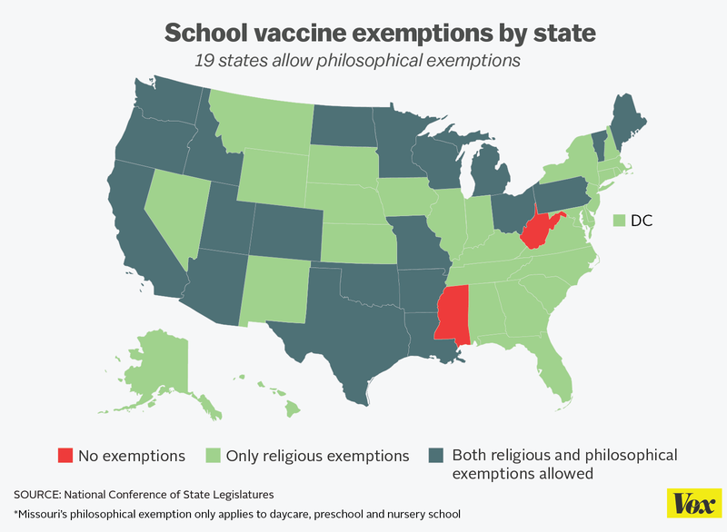
The state that leads the country in child vaccination rates probably isn’t the one you think.

Source: www.vox.com

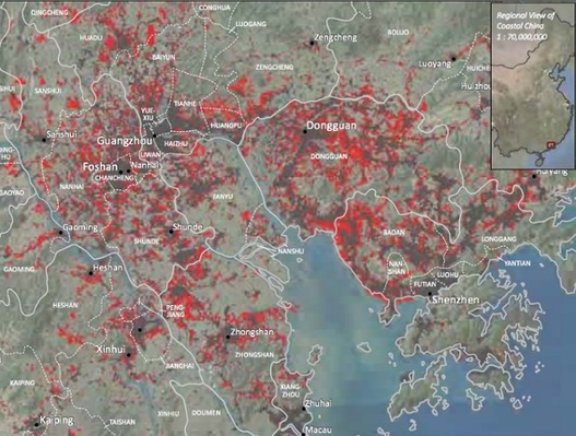
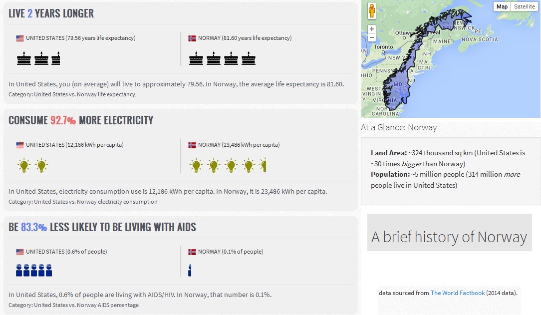
I had measles back in 1977, when I was too young to be vaccinated during an outbreak in the Southern California region.  My father-in-law still lives with the effects of Polio that he contracted when he was a toddler, right around the time of Jonas Salk’s great discovery that lead to the Polio vaccine.  I care about this issue because the effects are personal–but for too many, they’ve never known the realities of a world before vaccines. We collectively have forgotten WHY life expectancy and have steadily gone up over the decades at the same time that infant mortality rates have dropped.  It’s in large part because the nightmarish diseases of yesteryear have been eliminated, if we collectively are all immunized. Unfortunately, this is the discouraging truth (for now): anti-vaxxers are nearly impossible to convince. I hope this current measles outbreak is the tipping point for their to be enough public sentiment to lead to change, because the status quo is not acceptable; 113 countries currently have a better immunization rate for measles than the United States (here is Jon Stewart’s always entertaining rant on the topic). 

 Tagsmedical, diffusion, perspective.

Google Earth Pro is now free

Over the last 10 years, businesses, scientists and hobbyists from all over the world have been using Google Earth Pro for everything from planning hikes to placing solar panels on rooftops. Google Earth Pro has all the easy-to-use features and detailed imagery of Google Earth, along with advanced tools that help you measure 3D buildings, print high-resolution images for presentations or reports, and record HD movies of your virtual flights around the world.

Starting today, even more people will be able to access Google Earth Pro: we’re making it available for free. To see what Earth Pro can do for you—or to just have fun flying around the world—grab a free key and download Earth Pro today.”

Source: google-latlong.blogspot.com

China’s Pearl River Delta overtakes Tokyo as world’s largest megacity

Several hundred million more people are expected to move to cities in East Asia over the next 20 years as economies shift from agriculture to manufacturing and services, according to a World Bank report

Source: www.theguardian.com

Cities in this region have experienced spectacular growth; they are at the heart of China’s manufacturing and exporting boom.  For example, Shenzen was a small city with about 10,000 residents in 1980 but is now a megacity with over 10 million people.  China’s SEZs (Special Economic Zones).  Cities that were once separate entities have coalesced into a large conurbation and if they are counted as one, it’s now the largest metropolitan area.  Cities like London and New York become global cities over hundreds of years–this happened in one generation.  Click here for 5 infographics showing East Asia’s massive urban growth.      

Tags: APHG, urban, industry, manufacturing, economic, unit 7 cities, megacities, China, East Asia.

Folk Culture–Tradition

Source: www.youtube.com

The clip which starts at 0:25 (speaking at 0:50) is an audiovisually rich cultural collage.  Folk cultures are often described as regionally based, nearly homogenous, rural cultures.  These societies are typically dominated by the older generation, traditional, family-based and slow to change.  Folk cultures typically rural, religious, agricultural, family-based and in a word: traditional.  This classic movie’s opening is a good primer for markers of folk cultures and struggles that folk cultures have to maintain there vitality in a globalizing world.  If you continue on in the movie, the actual song Tradition is also rich in explaining how the society maintains itself.  


Tags: Russia, folk cultures, culture, music.

University Re-Imagines Town And Gown Relationship In Philadelphia

Drexel University is taking a hands-on approach to redeveloping one of Philadelphia’s poorest neighborhoods with a new center designed to serve not just students but mainly local residents.

Source: www.npr.org

This NPR podcast shows a good example of an urban revitalization project that is actively trying to avoid following the gentrification path.  Growing colleges can unintentionally displace longtime residents, but this project is about preserving the cultural fabric of the neighborhood and building good will in the community. 

Tags: neighborhoodpodcast, gentrificationurban, place, culture, economicracepoverty.

1940s Urbanism

“This is a film by the Chicago Board Of Education, produced sometime in the 1940s. This film could have been geared towards tourism or to entice companies to come to Chicago or used in the classroom.  The great thing about this film reel, is all the different views of the city they give.”

Tags: Chicago, urban, place, landscape,  video, urbanism.

Source: vimeo.com

Geography Education on Tumblr

Source: geographyeducation.tumblr.com

You can now get your ‘Geography Education’ on Tumblr, if that is a social media platform that you use. 

4 animations that show what’s really going on with our climate

“Trying to understand what’s actually going on in the world’s climate seems like it might be truly impossible. For one thing, there are so many different factors at work. Everything from how light travels through the atmosphere to how the winds move the ocean around to how rain hits the ground has an effect on what actually happens on Earth both now and in the future. That also means there’s absolutely no use in looking at each piece individually … to understand what’s really going on, the climate jigsaw puzzle needs to be complete.

That, says climate scientist Gavin Schmidt, is where climate modeling comes in. The discipline synthesizes data from multiple sources, including satellites, weather stations, even from people camping in the Arctic and submitting measurements of the ice they see around them. Climate modeling, Schmidt says, gives us our best chance of understanding the bigger picture of the world around us. ‘We take all of the things we can see are going on, put them together with our best estimates of how processes work, and then see if we can understand and explain the emergent properties of climate systems,’ he says. These four silent animations show what he means.”

Tags: physical, weather and climate, Arctic, Antarctica, climate change.

Source: ideas.ted.com

Worldwide Country Comparison

MyLifeElsewhere allows you to compare your home country with different countries around the world. Ever wonder what your life would be like if you were born somewhere else?”

Source: www.mylifeelsewhere.com

Did you know that with 1/30th the territory of the United States, Norway still has over 25% more coastline?  I didn’t either until I compared Norway to the United States using My Life Elsewhere.  This site is designed allow United States students to imagine how their lives might be different if they were born in a different part of the world.  Student would probably die 21 years earlier if they were born in Liberia and 11 times more likely to have died in infancy.   Students would be 43.8% less likely to grow up and be unemployed and have 36.3% less babies if they were born in Taiwan.  This side-by-side format is a great way to help students help make these statistics real and meaningful.  One major drawback: this site only allows users to compare a country to the United States.  If you prefer to have students compare, say Cuba to the United Arab Emirates, I would recommend that you try If It Where My Home.

Tags: comparison, worldwide, statistics, development.

Blog at WordPress.com.

Up ↑