Search

GEOGRAPHY EDUCATION

Supporting geography educators everywhere with current digital resources.

How Google represents disputed borders between countries

INTERNATIONAL borders are often tricky to chart on maps. Tangible topographic features can be pinned down by satellite imagery but the boundaries between many states…

Source: www.economist.com

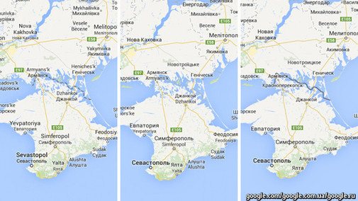
I’ve shared some links in the past that some mapping dilemmas with current events in Ukraine.  Google Maps shows international borders differently and National Geographic maps show Crimea as a part of Russia.  In this podcast we learn that this isn’t the only international border dispute that is displayed differently in Google Maps.  Google uses over 30 distinct versions of international borders because there is an underlying geopolitical dimension to cartographyHowever, this article from the Economist is more explicitly geographic in its analysis of the situation and how the discipline(s) of geography/cartography shape the political situation; maps are NOT just a reflection of reality on the ground.  To paraphrase the cartographer Andy Shears, there is a lot of teaching applications and discussion material in these articles. 

Questions to Ponder: Why have different cartography for different audiences?  Why does this small cartographic decision matter? How can maps be used to lie/stretch the truth?  How to governments derive political legitimacy from maps?   Why is Google the cartographic gatekeeper?

Tags: googleUkraine, mapping, borders, political.

Stop Complaining About Gentrification Unless You Know What It Is

“In many cities, it’s become popular to hate ‘gentrifiers,’ rich people who move in and drive up housing prices — pushing everyone else out. But what’s going on in these rapidly-changing urban spaces is a lot more complicated than that.”

Source: io9.com

Gentrification can be a very touchy subject.  What appears to be economic revitalization of a down-trodden neighborhood to one, can appear to be systematic removal of minorities to another.  This op-ed isn’t a whole-hearted embrace of gentrification, but it might be seen as a critique of the gentrification critics.


Tags: neighborhood, gentrificationurban, place, culture, economic.

Where China and Kazakhstan Meet

“While people often say that borders aren’t visible from space, the line between Kazakhstan and China could not be more clear in this satellite image. Acquired by the Landsat 8 satellite on September 9, 2013, the image shows northwestern China around the city of Qoqek and far eastern Kazakhstan near Lake Balqash.

The border between the two countries is defined by land-use policies. In China, land use is intense. Only 11.62 percent of China’s land is arable. Pressed by a need to produce food for 1.3 billion people, China farms just about any land that can be sustained for agriculture. Fields are dark green in contrast to the surrounding arid landscape, a sign that the agriculture is irrigated. As of 2006, about 65 percent of China’s fresh water was used for agriculture, irrigating 629,000 square kilometers (243,000 square miles) of farmland, an area slightly smaller than the state of Texas.

The story is quite different in Kazakhstan. Here, large industrial-sized farms dominate, an artifact of Soviet-era agriculture. While agriculture is an important sector in the Kazakh economy, eastern Kazakhstan is a minor growing area. Only 0.03 percent of Kazakhstan’s land is devoted to permanent agriculture, with 20,660 square kilometers being irrigated. The land along the Chinese border is minimally used, though rectangular shapes show that farming does occur in the region. Much of the agriculture in this region is rain-fed, so the fields are tan much like the surrounding natural landscape.”

Tags: remote sensing, land use, environment, geospatial, environment modify, food, agriculture, agricultural land change.

Source: earthobservatory.nasa.gov

Freakonomics » Parking Is Hell

“The episode begins with Stephen Dubner talking to parking guru Donald Shoup, a professor of urban planning at UCLA and author of the landmark book The High Cost of Free Parking. In a famous Times op-ed, Shoup argued that as much as one-third of urban congestion is caused by people cruising for curb parking. But, as Shoup tells Dubner, there ain’t no such thing as a free parking spot.”

Source: freakonomics.com

Everyone searching for a parking space has at one time felt that there are not enough spaces where and when you need them…did you know that their are at least 3 surface lot parking spaces for every car in the United States (not including garages, driveways, etc)?  With 250 million passenger vehicles for 316 million people, that means there are 800 million surface lot parking spaces (that account for only 60-70% of our parking needs).  Parking then is a much bigger issue that we want to believe; this is one of the reasons why IKEA is starting to rethinking their construction model that historically has been designed around huge parking lots.   

Tags: urban, urban ecology, transportation, planning.

How to Follow the Iceland and Papua New Guinea Volcano Eruptions

Webcams, Twitter, and data visualizations show you what’s going on with Bárðarbunga and Mount Tavurvur.

Source: www.citylab.com

Beautiful Landscapes

“Here’s a collection of timelapses I shot during the past year. Amazing landscapes from California, Arizona, Bahamas, Florida, Japan, Taiwan to Italy.”

Source: vimeo.com

Part of a teaching geography is showing the wonders of the Earth in as way that will hopefully spark some awe, curiosity, and desire to see more of the planet.  I think this video is a nice primer for that.  

Tags: landscape, time lapsevideo.

Comparing the five major world religions

“It’s perfectly human to grapple with questions, like ‘Where do we come from?’ and ‘How do I live a life of meaning?’ These existential questions are central to the five major world religions — and that’s not all that connects these faiths. John Bellaimey explains the intertwined histories and cultures of Hinduism, Judaism, Buddhism, Christianity and Islam.”

Source: www.youtube.com

This TED ED Lesson outlines the basics of five major world religions which in turn have profoundly reshaped the cultural geographies we see today.  While the narration in the video might be a bit dry, the visuals immerse the viewer into the cultural context from which these religions emerged.   


Tags: religion, culture, TEDChristianity, Islam, unit 3 culture.

Why everyone should be able to read a map

New research suggests that map reading is a dying skill in the age of the smartphone. Perish the thought, says Rob Cowen

Source: www.telegraph.co.uk

Despite the gendered overtones of the article (that it’s important for men to learn to read a map), this is some good advice, regardless of gender.  The vocabulary and concepts of maps can strengthen spatial cognition and geography awareness.  While GPS technology can help us in a pinch, relying primarily on a system that does not engage our navigation skills will weaken our ability to perform these functions.  While it intuitively makes sense, that the ‘mental muscles’ would atrophy when not used, it is a reminder that an overuse of geospatial technologies can be intellectually counterproductive.  So break out a trusty ol’ map, but more importantly, be a part of the spatial decision-making process. 


Tagsmappingspatial, technology, education.

This Fall, Minorities Will Outnumber White Students in U.S. Schools

“While 62 percent of the total U.S. population was classified as non-Hispanic white in 2013, when public schools start this fall their racial landscape will reflect a different America.”

Source: www.theatlantic.com

A new report new shows the changing demographics in American education and how it differs from that of the general population.  The demographic shifts in the United States are transforming the cultural fabric of the country and this interactive feature from the Pew Research Center explores some of these changes.  What are some of the reasons and what are some of the impacts?

Tag: declining populations, population, demographic transition model, USA.

Blog at WordPress.com.

Up ↑