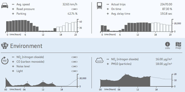
Search

GEOGRAPHY EDUCATION

Supporting geography educators everywhere with current digital resources.

Amsterdam City: a City as Urban Statistics

Amsterdam City Dashboard presents the city of Amsterdam through the lens of data, including demographic statistics, traffic reports, noise readings or political messages.

The small collection of information graphics are divided in distinct domains, such as transport, environment, statistics, economy, social, cultural and security. All data is shown in near real-time, based on blocks of 24 hours. Larger dots and darker colors symbolize higher values, whereas an interactive map provides a geographic reference.”

Tags: Netherlands, urbanstatistics, urban ecology, transportation, planning.

Source: infosthetics.com

EU debates biopiracy law to protect indigenous people

Pharmaceutical companies would need to compensate indigenous people for using their knowhow in creating new medicines

Source: www.theguardian.com

I’d never hear the term biopiracy before this month, but this idea is this: companies from wealthy countries commercially develop the genetic resources of developing countries with local assistance but don’t fairly compensate the local population.  I never had the vocabulary to describe such a thing, but that is biopiracy in a nutshell and the EU is working to end that.  It doesn’t only impact the pharmaceutical companies but heavily impact the agricultural industries as well.  Anyone in the developed world eating quinoa and kale 20 years ago?  Being marketed as ‘superfoods’ has changed the global production systems but also impacted local indigenous food supplies (some are referring to this as food gentrification). 

Tagsfood productiontechnology, industry, food, agriculture, agribusiness, globalization, folk cultures, indigenous.

Welcome To Geography!

“Lets start off the new school year in style! This is a re-imagining of an older resource designed to introduce the subject to new students in a highly visual manner.  Feel free to use & share it.”

Source: www.slideshare.net

Admit it…geographers have to sell geography.  This geography teacher has done a fabulous job of demonstrating what geography is in an engaging, relevant way to start the year off right

Tags: geo-inspiration, geography education.


Worst Hurricane

“What’s the worst Hurricane anyone in your town remembers?””

Source: xkcd.com

Click here to see a higher resolution version of this map (don’t dismiss it as just a cartoon!).  

Mapping the Spread of Drought Across the U.S.

Maps and charts updated weekly show the latest extent of the drought in the United States.

Source: www.nytimes.com

I’ve shared numerous links here about the drought situation in California over the past few months, but the situation extends far beyond California as these animated maps and charts demonstrate. Some of the best public data on drought can be found at the National Drought Mitigation Center

Tags: wateragriculture, environmentresources, environment depend, physical, weather and climate, consumptionCalifornia.

Flip-Flop Summer Caused by Strange Jet Stream

“Temperatures across the Northeast have been unusually cool, and they have been unusually hot across the northwest.  A strange jet stream is behind the flip-flop between summer conditions in the two northern corners of the country. The polar jet stream is the prevailing band of wind that blows west to east across the upper half of the U.S. in summer. (There is a subtropical jet, also, that typically crosses northern Mexico).  We often see the jet stream depicted on TV weather reports—that big, wavy line across the U.S. and Canada that bends south then north then south again. Low-pressure weather systems, sometimes called cold fronts, ride along the jet stream, bringing us much of our daily weather. But this summer the polar  jet steam seems to be somewhat flattened out, and it’s been in that position more than usual.”

Tags: physical, weather and climate, seasonal.

Source: blogs.scientificamerican.com

Why Paris doesn’t want a Scottish Yes

“Nothing unites different nations quite like mutual enemies. But the ‘Auld Alliance’ between Scotland and France – both historic rivals of England – doesn’t mean that the French government favours Scottish independence. Far from it.”

Source: www.bbc.com

Historically, France has supported greater autonomy or independence as a way to limit English political power and influence.  However in the era of the E.U. and greater regional integration, modern geopolitics makes this old alliance untenable as some in Scotland are seeking independence from the United Kingdom.  


Tags: devolutionhistorical, supranationalism, political, states, sovereignty, autonomy, Europe, unit 4 political, geopolitics.

Canada on mission to map Arctic, lay claim to broader boundaries

Canada has dispatched two icebreakers to map the Arctic seabed beneath the North Pole to support a bid to extend the country’s maritime territory deeper into the waterways at the top of the world.

Source: www.latimes.com

Canada, Russia and Denmark (Greenland) are all seeking to expand their maritime claims in the Arctic.  Globally speaking, the retreat of Arctic sea ice can be seen as a unmitigated disaster, but disasters for the many can open up new economic opportunities for the few.  When trapped under ice, extracting resources is cost prohibitive, but the melting sea ice will make the Arctic’s resources all the more valuable (including the expanded shipping lanes).  This fits in with the APHG new course outline which includes political ecology (the study of the political and economic principles controlling the relations of human beings to one another and to the environment).
 

Tagseconomic, environment, political, resources, water, sovereignty, coastal, environment depend, territoriality, unit 4 political, Arctic, climate change, political ecology.

What You Need to Know About the Ebola Outbreak

Questions and answers on the scale of the outbreak and the science of the Ebola virus.

Source: www.nytimes.com

This Ebola outbreak began in Guinea, near the border with Sierra Leone and Liberia, where a network of roads makes the movement of people, goods ideas possible.  Unfortunately though, those same roads make spread of diseases easier.  In the past African Ebola cases in isolated villages could be contained but increased transportation has accelerated the diffusion process.  If this spreads to Lagos, watch out.


medical, development, diffusion.

Create a free website or blog at WordPress.com.

Up ↑