Search

GEOGRAPHY EDUCATION

Supporting geography educators everywhere with current digital resources.

Do you know Africa?

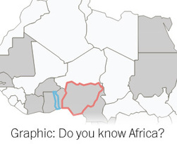
Many of Africa’s leaders will be in town next week attending a White House summit. The continent’s land is shared among 49 countries — many of which rarely make U.S. headlines. How familiar are you with Africa’s geography?

Source: www.washingtonpost.com

This online quiz tests your ability to locate African countries on the map–a basic skill that isn’t ‘doing geography’ (an age-old lament among geography educators).  Still, it is hard to have an intelligent discussion about the continent if you can’t name or locate any places other than Egypt and South Africa.  For some of my favorite online map quiz resources, click here.


Tags: Africa, regions, trivia, games.

First taste of chocolate

“To be honest I do not know what they make of my beans,” says farmer N’Da Alphonse. “I’ve heard they’re used as flavoring in cooking, but I’ve never seen it. I do not even know if it’s true.” Watch how the Dutch respond to a cocoa bean in return or you can watch our entire episode on chocolate here.

Source: www.youtube.com

What is the geography of chocolate like?  This video was produced in the Netherlands, the global center of the cocoa trade, but the world’s leading producer of cocoa is Côte d’Ivoire.  There is a dark side to chocolate production; the dirty secret is that slavery is commonplace on cocoa plantations in West Africa.  Although the worst of the situation is glossed over in this video, it still hints at the vast economic inequalities that are part and parcel of the global chocolate trade and the plantation roots of the production.  What are some of your reactions to this video?  


Tags: chocolate, Ivory CoastAfrica, poverty, development, economic, globalization, industry, labor.

40 Maps That Explain The Middle East

These maps are crucial for understanding the region’s history, its present, and some of the most important stories there today.

Source: www.vox.com

Titles like the one for this article, 40 maps that explain the Middle East, are becoming increasingly common for internet articles.  They helps us feel that we can explain all of the world’s complexities and make sense of highly dynamic situations.  While we can all agree that maps are great analytical tools that can be very persuasive, sometimes we can pretend that they are the end all, be all for any situation.  Maps can also be used to show how something that we thought was simple can be much complex and nuanced than we had previously imagined, as demonstrated by this article, 15 Maps that Don’t Explain the Middle East at All.  Both perspectives have their place (and both articles are quite insightful). Not connected to the Middle East, but East Asia, this article entitled Lies, Damned Lies and Maps continues the discussion of maps, truth and perception. 


Tags: MiddleEast, conflict, political, borders, colonialism, devolution, historical, mapping.

Poop Stories

“From the time we’re about 6 years old, everyone loves a good poop joke, right? But is there something more meaningful lurking beneath the bathroom banter? Take a look at some international potty humor and then follow the jokes to a deeper understanding. Every laugh on this page reflects a life and death issue: the very real sanitation problems facing India today.”

Source: www.standupplanet.org

What is the most impactful way to assist underdeveloped societies?  Many will argue for food, clothing or education, but these comedians from India feel that access to sanitation will have more tangible impacts in the lives of the poorest Indians.  54% of people in India do not have regular access to toilets and these comedians are using their platform to not only get some laughs, but to advocate for social change. 

Tagsdevelopment, poverty, India.

Local Population Pyramids

Source: developers.arcgis.com

Have you even wanted to explore an interactive map of the United States and be able to click on any neighborhood to see the local population age structure and compare that to the national, state or county data?  If not, you don’t know what you’ve been missing.  This is a fantastic resource that lets you and your students explore the data AND ask spatial questions.  It’s definitely one that I’ll add to my list of favorite resources.  


Tag: population, population pyramidsmappingcensus, visualization, USA.

How Cities Use Design to Drive Homeless People Away

“Saying ‘you’re not welcome here’—with spikes.”

Source: www.theatlantic.com

Geography explores more than just what countries control a certain territory and what landforms are there.  Geography explores the spatial manifestations of power and how place is crafted to fit a particular vision.  Homeless people are essentially always ‘out of place.’  This article from the Atlantic and this one from the Guardian share similar things: that urban planners actively design places that will discourage loitering which is undesirable to local businesses.  This gallery shows various defensive architectural tactics to certain people feel ‘out of place.’  Just to show that all urban designs are anti-homeless, this bench is one that is designed to help the homeless.     

Tags: urbanplanning, architecture, landscape, place.

Colombia’s Herd of Hungry Hippos

“A herd of hippopotamuses once owned by the late Colombian drug baron Pablo Escobar has been taking over the countryside near his former ranch – and no-one quite knows what to do with them.”

Source: www.bbc.com

An important idea in biogeography is the concept of invasive species. An invasive species is an organism that is not indigenous to an area but causes great economic or environmental harm to the new area as it quickly adapts and alters the ecosystem.   Colombia’s hippopotamus herd certainly qualifies as an interesting example to share with students of unintended ecological consequences that occur through human and environmental interactions.  For further explorations into invasive species, see this National Geographic lesson plan.   


Tags: biogeography, environmentecology, Colombia, National Geographic.

‘The Great Fish Swap’: How America Is Downgrading Its Seafood Supply

“One-third of the seafood Americans catch is sold abroad, but most of the seafood we eat here is imported and often of lower quality. Why? Author Paul Greenberg says it has to do with American tastes.”

Source: www.npr.org

The United States exports the best-quality seafood that Americans catch, but import primarily low-grade aquacultural products.  This is just one of the counter-intuitive issues withe U.S. fish consumption and production.  This bizarre dynamic has cultural and economic explanations and this NPR podcast nicely explains these spatial patterns that are bound to frustrate those that advocate for locally sourced food productions. 

Tagsfood production, industry, food, agriculture, agribusinessconsumptioneconomic, sustainability.

Why Finnish babies sleep in boxes

“For 75 years, Finland’s expectant mothers have been given a box by the state. It’s like a starter kit of clothes, sheets and toys that can even be used as a bed. And some say it helped Finland achieve one of the world’s lowest infant mortality rates.”

Source: www.bbc.com

This is a fascinating article that can be a great case study to share with students to allow them to analyze the factors that can improve infant mortality rates.  In Finland the government provided oversight to improve infant mortality rates, pre-natal care and promote good parenting in a way that has had tangible results.  

Tags: Finland, medical, population,demographic transition model, unit 2 population.

Create a free website or blog at WordPress.com.

Up ↑