Search

GEOGRAPHY EDUCATION

Supporting geography educators everywhere with current digital resources.

Ethiopia’s Dam Problems

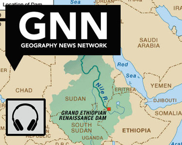
“Ethiopia is three years from completing a dam to control its headwaters, and while Egypt points to colonial-era treaties to claim the water and to stop the project, the question remains as to who own the Blue Nile.”

Source: maps101blog.com

This 7-minute Geography News Network podcast (written by Julie and Seth Dixon) touches on some key geographic concepts.  85% of the Nile’s water comes from the Blue Nile that originates in the Ethiopian highlands–it is the Blue Nile that Ethiopia has been working on damming since 2011.  The Grand Ethiopia Renaissance Dam (GERD) will be located  near the border with Sudan.  Egypt is adamantly opposed to Ethiopia’s plan and is actively lobbying the international community to stop construction on the dam, fearing their water supply with be threatened. 

Tags: Ethiopia, Africa, development. environment, water, energy, borders, political.

Chinese Uyghurs defy Ramadan ban

“The government’s attempt to clamp down on religious expression has backfired among Uyghurs.”

Source: www.aljazeera.com

China has used various means to eliminate minority groups’ cultural identity, and human rights groups argue that this ban on Ramadan is no different (children and government employees are banned from fasting, allegedly for health and safety concerns).  Ethnic Uyghurs speak a Turkic language are more culturally connected to Cental Asia than East Asia.  Predominantly Muslim, the Uyghurs are defying some of the more controversial laws that they feel single them out.   


Tagsethnicityconflict, politicalreligion, China.

Where Do Borders Need to Be Redrawn? – Room for Debate

What parts of the world should rethink their maps? Why and how?

Source: www.nytimes.com

Maps are always changing as a new nation gets added and old lines cease to make sense. Territory is claimed and reclaimed.  This series of seven articles in the New York Times explores regional examples of how borders impacts places from a variety of scholarly perspectives.  Together, these article challenge student to reconsider the world map and to conceptualize conflicts within a spatial context.


Tags: bordersmapping, political, territoriality, sovereignty.

China’s hungry cattle feasting on alfalfa grown on Utah farm

China has long depended on the U.S. breadbasket, importing up to $26 billion in U.S. agricultural products yearly. But increasingly, Chinese investors aren’t just buying from farms abroad. They’re buying the farms.

Source: www.mcclatchydc.com

Globalization is often described as a homogenizing force, but is also pairs together odd bed fellows.  A small Utah town near the Colorado border, Jensen is now home to the largest Chinese-owned hay farm in the United States. Utah’s climate is right for growing alfalfa, and China’s growing cattle industry make this a natural global partnership.  Large container ships come to the United States from China, and return fairly empty, making the transportation price relatively affordable.  Locally back in the United States though, water resources are scarce and many see this as a depletion of local water exported to China.  Some states see this as a threat and are considering banning foreign ownership of farmland.  This article shows the merging various geographic themes: the global and local, the industrial and the agricultural, the human and the physical.         

Tags: agriculture, agribusinesstransportation, globalizationwaterChinaindustry, economic, physical, Utah.

China publishes new map

China has published a new map of the entire country including the islands in the South China Sea (West Philippine Sea) in order to “better show” its territorial claim over the region.

Source: globalnation.inquirer.net

China is attempting to bolster its geopolitical claims through cartographic validation.  It as if to say, ‘it’s on a map, who can question that it is legitimately our territory?’  Why is a map such a powerful and convincing document?  Why is the Philippines upset by this map?  I think that explains this rival Filipino map as the Philippines and China engage in the cartographic version of dueling banjos.  (note the uage of the South China Sea or West Philippine Sea to refer to the same body of water) .  But this is more than just a map; it’s production has the potential to destabilize regional security.     

For more resources, the Choices Program has put together supplemental materials to investigate China on the world stage.

Tags: borderstoponyms, political, conflict, waterChina, East Asia.

The tragedy of the Arabs

“A THOUSAND years ago, the great cities of Baghdad, Damascus and Cairo took turns to race ahead of the Western world. Islam and innovation were twins. The various Arab caliphates were dynamic superpowers—beacons of learning, tolerance and trade. Yet today the Arabs are in a wretched state. Even as Asia, Latin America and Africa advance, the Middle East is held back by despotism and convulsed by war.  

Pluralism, education, open markets: these were once Arab values and they could be so again. Today, as Sunnis and Shias tear out each others’ throats in Iraq and Syria and a former general settles onto his new throne in Egypt, they are tragically distant prospects. But for a people for whom so much has gone so wrong, such values still make up a vision of a better future.”

Source: www.economist.com

While the title of the article is more inflammatory than I would prefer, the analysis in this article from the Economist does a good job linking the cultural, economic and political struggles in the Middle East.

Tags: political, culture, economic, Islam, MiddleEast.

This Is the Traffic Capital of the World

There are only 650 major intersections here—but somehow only 60 traffic lights.

Source: www.newrepublic.com

Dhaka is the capital of Bangladesh and (as I often tell my students) it is the biggest city that nobody has ever heard of.  The infrastructure is so incredibly limited that traffic jams cost the city an estimated $3.8 billion in delays and air pollution.  This is an excellent article to explore some of the problems confronting megacities. 

Tags: Bangladeshtransportation, planning, density, South Asia, development, economic, megacities.

Revolutionary War Battles

America’s war for indpendence began on April 19, 1775, when the first shots were fired at Lexington and Concord in Massachusetts.

Tags: USA, historicalmapping, National Geographic.

Source: education.nationalgeographic.com

Google Maps Smarty Pins

Smarty Pins is a Google Maps based geography and trivia game.

Source: smartypins.withgoogle.com

As stated in a review of Smarty Pins on Mashable, “Google unveiled a fun new game this week that tests players’ geography and trivia skills.  Called ‘Smarty Pins’ the game starts players off with 1,000 miles (or 1,609 kilometers if they’re not based in the United States), and asks them to drop a pin on the city that corresponds with the correct answer to a given question.” 


This game is wonderfully addictive…I haven’t enjoyed a mapping trivia platform this much since I discovered GeoGuessr.  I answered 38 questions before I ran out of miles…how far did you get?  

Tagsgoogle, fun, mapping, place, trivia.

Blog at WordPress.com.

Up ↑