Seth Dixon‘s insight:
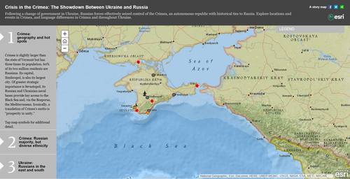
This StoryMap from ESRI is a nice way to explore Crimean historical geography, as is this set of maps from National Geographic.
See on storymaps.esri.com
This StoryMap from ESRI is a nice way to explore Crimean historical geography, as is this set of maps from National Geographic.
See on storymaps.esri.com
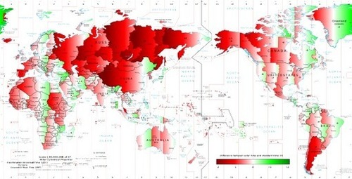
Why Spaniards have dinner so late? A map of the difference between solar time and clock time around the world.
I edited a world map from Wikipedia to show the difference between solar and standard time. It turns out, there are many places where the sun rises and sets late in the day, like in Spain, but not a lot where it is very early (highlighted in red and green in the map, respectively). Most of Russia is heavily red, but mostly in zones with very scarce population; the exception is St. Petersburg, with a discrepancy of two hours, but the effect on time is mitigated by the high latitude. The most extreme example of Spain-like time is western China: the difference reaches three hours against solar time. For example, today the sun rises there at 10:15 and sets at 19:45, and solar noon is at 15:01.
See on poisson.phc.unipi.it
Why Spaniards have dinner so late? A map of the difference between solar time and clock time around the world.
I edited a world map from Wikipedia to show the difference between solar and standard time. It turns out, there are many places where the sun rises and sets late in the day, like in Spain, but not a lot where it is very early (highlighted in red and green in the map, respectively). Most of Russia is heavily red, but mostly in zones with very scarce population; the exception is St. Petersburg, with a discrepancy of two hours, but the effect on time is mitigated by the high latitude. The most extreme example of Spain-like time is western China: the difference reaches three hours against solar time. For example, today the sun rises there at 10:15 and sets at 19:45, and solar noon is at 15:01.
See on poisson.phc.unipi.it
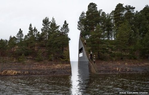
“A slice of rock removed from the mainland near the island of Utoeya is the winning design for a memorial to commemorate the victims of Norwegian mass killer Anders Behring Breivik.”
Monument are not just in a place…they can create place and place can infuse added meaning to a memorial. This is a great example of the interplay between memorials, place, artistic and cultural meanings.
See on www.bbc.com
Reuters photographer Carlos Barria recently spent time in Shanghai, China, the fastest-growing city in the world. A week ago, he took this amazing shot, recreating the same framing and perspective as a photograph taken in 1987, showing what a difference 26 years can make. The setting is Shanghai’s financial district of Pudong, dominated by the Oriental Pearl Tower at left, and the new 125-story Shanghai Tower, China’s tallest building and the world’s second tallest skyscraper, at 632 meters (2,073 ft) high, scheduled to finish by the end of 2014. Shanghai, the largest city by population in the world, has been growing at a rate of about 10 percent a year the past 20 years, and now is home to 23.5 million people — nearly double what it was back in 1987. This entry is focused on this single photo pairing, with several ways to compare the two.
In the Atlantic, there was an article that highlighted some incredible comparisons of Shanghai’s Pudong district that show the impact globalization. This image is my rendering of the two images as a composite image. Globalization has hit…hard and fast. Today, we shouldn’t think of Shanghai as a major city in China, but as as one of the major cities in the world..
See on geographyeducationdotorg.files.wordpress.com
Shanghai wasn’t the only city to grow tremendously during a globalization boom…Here is Dubai.

If you haven’t discovered CGP Grey yet, his YouTube channel is a veritable fountain of geographic tidbits. His distinctive style helps to contextualizes some of the more odd and complicated parts of the Earth (but some find the rush of facts disorienting). If you want another example, watch Bizarre Borders, part 2 which focuses on the complexities of the US/Canadian border.
Tags: borders, political, territoriality, sovereignty, CGP Grey.
See on www.youtube.com
This is just for fun…but it is a way to start some conversations about modern agricultural practices, especially the local and organic movements.
See on www.youtube.com
A Human Geography Resource; Especially for Teachers
The Human Imprint is home to everything Human Geography related for the student, educator, and the every day Joe/Jane. This site includes geographic related stories, lesson plans, and other links that bring us closer to understanding the “why of where.”
Have you already seen this resource produced by a Chicago AP Human Geography teacher? If not, there’s no time like the present!
See on thehumanimprint.com
Elmhurst College’s Skills for the Digital Earth MOOC is a 4-week, online course designed to introduce how location technologies are used in society.
Ever stop to think about how important location is when using your smart phone? This educational MOOC begins with an elementary explanation of how society uses location in a myriad of disciplines. Geography, or rather, “where?” is important to all of us from various perspectives.
Within this MOOC, participants will learn what location technologies are used for, how the discipline developed and learn by doing via a series of scaffolded practical exercises. Online spatial software will be employed for any device using a browser which takes users through exercises and real world examples. It is appropriate for those with no prior experience with geographic information systems (GIS) software all the way to advanced users.
Skills for the Digital Earth will incorporate video lectures, interaction opportunities and discussion forums. Each module will feature a quiz and activities, and participants will receive a badge after each completed module to be used to demonstrate skills mastered.
I am very excited about this free MOOC offered through the Elmhurst College Online Center (they also offer the Graduate Certificate Program for AP Human Geography teachers). The instructor, Dr. Rich Schultz is the Associate Director of the National Geospatial Technologies Center of Excellence.
See on opencourses.desire2learn.com