Via Scoop.it – Geography Education

This blog post outlines an excellent craft activity designed for K-6 students to teach the concept of scale.
Via Scoop.it – Geography Education
This blog post outlines an excellent craft activity designed for K-6 students to teach the concept of scale.
Via Scoop.it – Geography Education
by The East India Company with Sam Joyce Conduit Street, Mayfair…
This London Egg is fantastic. Happy Easter.
Via Scoop.it – Geography Education
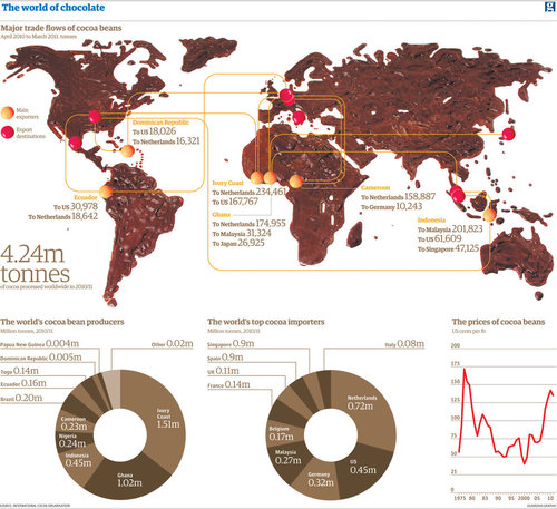
You may be focussing on chocolate over the weekend – but where does it come from? A global trade analysed. In chocolate (this is what maps are made for!
What is the geography of chocolate like? There is a dark side (no pun intended) to the production of cocoa in many places such as West Africa.
Via Scoop.it – Geography Education
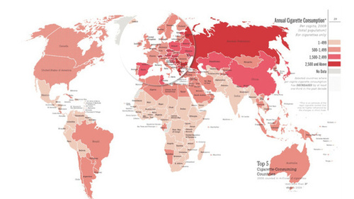
Between 1990 and 2009, cigarette consumption in regions of the world like Western Europe dropped by more than 25% – but that is only one side of the coin. Historically, cigarette consumtion has been a privilege to the rich and high-income countries. Now, with those countries understanding the risks of cancer and the dangers of smoking, the number of smokers decline. But in the past twenty years, for example, the use of cigarettes in the Middle East and Africe has increased by 60%: “Among the 14 countries where 50% or more of men smoke all but one country (Greece) are classified as low- or middle-income.”
“As consumption rates continue to increase in low- and middle-income countries,” the ACS report reads, “these countries will experience a disproportionate amount of tobacco-related illness and death.” In 2009, China consumed 40% of the world’s cigarettes.
Via Scoop.it – Geography Education
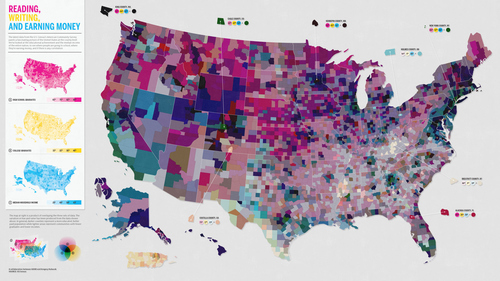
The latest data from the U.S. Census´s American Community Survey paints a fascinating picture of the United States at the county level. What are the connections between place, education and earning power? What patterns are what you would imagine? Why? Any shocking patterns that emerge from this dataset?
Via Scoop.it – Geography Education
As a team works to restore the North Carolina-South Carolina border to the original 1772 lines, some worry about the consequences.
Old maps and borders where often determined by local landmarks like trees, rivers, roads, fences, etc. Trees get uprooted and over time, rivers will wend their way down slightly different paths and the informal old borders get called into question. The border between North and South Carolina, traversing through swampy forested area was imperfect and now that they are trying to rectify it, some South Carolina residents face the prospect of needing to be North Carolina residents…not a small thing when you consider the utilities, government documents, taxes and voting.
Via Scoop.it – Geography Education
50 Pictures Of Chernobyl 25 Years After The Nuclear Disaster: Today marks the 25th anniversary of the Chernobyl nuclear disaster. …
A haunting gallery that displays the effects of environmental and political mismanagement.
Via Scoop.it – Geography Education
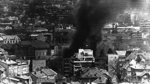
Twenty years ago this week, the Bosnian war began with the siege of Sarajevo, the longest in the history of modern warfare. The siege ended more than three years later, leaving 100,000 dead — the worst atrocities in Europe since World War II.
Ethnic and political conflict led to the disintegration of Yugoslavia in the 1990s. This NPR podcast is a good recap that shows the devolutionary forces of ethnic, religious, cultural and political differences that led to tragic violence and ethnic cleansing.
Via Scoop.it – Geography Education
If we built village of small streets today, where would we locate it?
One great candidate would be a park-and-ride lot, which is parking located next to a subway or commuter rail station. Such parking gets some to use public transit who wouldn’t ordinarily…
But that’s just the problem: the people who use park-and-ride lots don’t ordinarily take transit. The reason they have to drive to a train station is that they don’t live near it. That’s why building new neighborhoods next to transit (called transit-oriented development in planner lingo) has become popular in the last 10 years.
If we built a small streets village next to transit station, then we’d have a whole village of people who could use transit for all of their trips longer than a walk or bicycle ride away.
There are countless park-and-ride lots to consider, but we’ll look at just a couple. Greenbelt Station is located in Maryland at one end of Metro’s Green Line, which goes through Washington, DC and back out to Maryland. If you’ve ever hopped a ride on the Bolt Bus from New York City or the bus from BWI Airport, you may have visited this station…