Search

GEOGRAPHY EDUCATION

Supporting geography educators everywhere with current digital resources.

Portraits Of NYC Immigrants Reveal Cultural Backgrounds

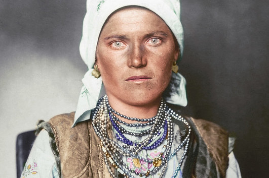
Here are just a handful of the 12 million men, women, and children who arrived at Ellis Island, New York, between 1892 and 1954 to start a new life in the USA, often dressed in their finest clothes. The portraits show immigrants wearing the national dress of their country of origin, including military uniforms from Albania, bonnets from the Netherlands, and clothing of Sámi people from the Arctic regions.

The photographs were taken between 1906 and 1914 by amateur photographer Augustus Francis Sherman, the chief registry clerk at Ellis Island, then the country’s busiest immigration station. In 1907 some of the photos were published by National Geographic.

Source: www.buzzfeed.com

These images show some of the diverse cultural backgrounds of turn-of-the-century American immigrants.  The formal clothing that represents the folk cultures that they came from hint at the massive cultural shift that these immigrants must have experienced upon arriving to the United States.  These photos of migrants wearing clothing representing their Old World lives right as they are about to culturally assimilate (or acculturate) into the New World are pictures I find quite poignant and personal.    


Tagsculturemigrationhistorical, folk culturesethnicity, unit 3 culture.

Why America’s ‘nones’ left religion behind

With the percentage of U.S. adults who do not identify with a religious group growing, we asked these people to explain, in their own words, why they left.

Source: www.pewresearch.org

The United States’ population is becoming increasingly secularized.  The U.S. used to be predominantly a white, Christian country but that is no longer the case.  As religion becomes less of a factor in the lives of many individuals, it also has larger cultural ramifications. 


Tags: culturereligionUSA, Christianity.

It was always better back in the day…

Start remembering your bathroom experiences again with our new handcrafted toilet paper. Inspired by the makers of yesterday and today.

Source: www.youtube.com

These spoofs are just for fun…but they are basic ways to start some conversations about how in our mass consumption society, we can wax nostalgic about how thing used to be better, but still enjoying modern comforts.  Especially in agricultural practices, and this spoof of modern food concerns that we can see to some degree in the local and organic movements.  Here is another spoof, mocking paleo and crossfit trends.  

‘The Wall Is a Fantasy’

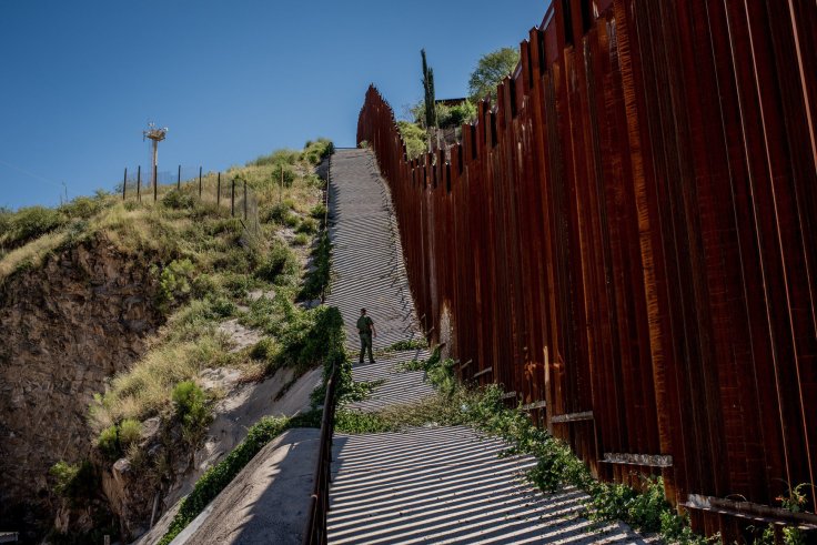
A week in the borderlands with migrants and guards.

Source: www.nytimes.com

This is not a political statement but a reiteration of the geographic realities of borders; they are inherently permeable and unite people just as much as they divide. 


Tags: Mexico, borders, political.   

Visualizing Exotic Travels

Source: www.youtube.com

When I watched this cartographic depiction of Indiana Jones’ adventures in Raiders of the Lost Ark as a kid, I was fascinated by the power of the map they used to segue between scenes.  It heightened the level of mystery and intrigue; I felt as if a whole new world was opening up as I was living vicariously through Dr. Jones.  This movie and its maps instilled in me a passion for global adventure, or at least a desire to learn about far off places…so get out there and explore.


Tagsmobilitytransportationtourismmapping, place.

New Human Geography Video Series

Miriam Nielsen will be teaching Human Geography on Crash Course. We’ll talk about what Human Geography isn’t, and what it is. Let’s talk about humans in the context of our world.

Source: www.youtube.com

Yesterday the popular video channel Crash Course announced that they would be producing a new series dedicated to human geography, much to the delight of APHG teachers everywhere (some wished it were John Green hosting the series, but I say we should give Miriam Nielsen a chance to win us over).  I’m sure that as more videos are produced, I will tag them and include them here on Geography Education.    


Tags: APHG, teacher training, edtech, video.

What’s the tallest mountain on Earth?

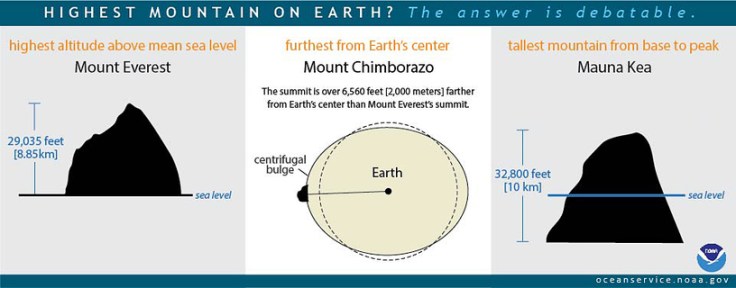
“Mount Everest is usually said to be the highest mountain on Earth. Reaching 29,035 feet at its summit, Everest is indeed the highest point above global mean sea level—the average level for the ocean surface from which elevations are measured. But the summit of Mt. Everest is not the farthest point from Earth’s center.

Earth is not a perfect sphere, but is a bit thicker at the Equator due to the centrifugal force created by the planet’s constant rotation. Because of this, the highest point above Earth’s center is the peak of Ecuador’s Mount Chimborazo, located just one degree south of the Equator where Earth’s bulge is greatest. The summit of Chimborazo is 20,564 feet above sea level. However, due to the Earth’s bulge, the summit of Chimborazo is over 6,560 feet farther from the center of the Earth than Everest’s peak. That makes Chimborazo the closest point on Earth to the stars.  

You may be surprised to learn that Everest is not the tallest mountain on Earth, either. That honor belongs to Mauna Kea, a volcano on the Big Island of Hawaii. Mauna Kea originates deep beneath the Pacific Ocean, and rises more than 32,800 feet from base to peak.”

Source: oceanservice.noaa.gov

I’ve tried to answer this question without any visual aids and there is always at least one confused look in the class.  This infographic is the most straightforward way to give the ‘long’ answer to a seemingly simple question, “what is the tallest mountain on Earth?”  It all depends on how you measure it and what your reference point is.   


Tags: physicalEcuador, Nepal.

Country Cluster Quiz

“No borders. No landmarks. No context. How many countries will you be able to recognize? Here’s how this works. I give you a the outline of several countries together, without borders or any other context, and you guess which countries you’re looking at.”

Source: www.buzzfeed.com

This is not the most difficult geography quiz (as advertised on Buzzfeed), but it does take some time since all the countries in a given cluster aren’t all immediately obvious.  The fact that it is multiple choice certainly simplifies the this quiz.


Tagsmapping, trivia, funborders.

The Worst Mistake in the History of the Human Race

“Forced to choose between limiting population or trying to increase food production, we chose the latter and ended up with starvation, warfare, and tyranny. Hunter-gatherers practiced the most successful and longest-lasting life style in human history. In contrast, we’re still struggling with the mess into which agriculture has tumbled us, and it’s unclear whether we can solve it.”

Source: discovermagazine.com

Jared Diamond wrote this highly controversial essay back in the 80’s and it still can elicit strong reactions from anthropologists, geographers, historians, and other scholars.  This is a good reading to give students during an agricultural unit.  This can get students to question many of the assumptions about humanity that they probably never knew they had (Diamond challenged the mainstream progressivist position).


Questions to Ponder: What is the progressivist view?  What were the negative impacts that early agriculture had on human health?  What social problems does Diamond attribute to agriculture?  What evidence would you present to argue against Diamond’s position?


Tagsagriculturefolk culturestechnologyindigenous.

Create a free website or blog at WordPress.com.

Up ↑