Search

GEOGRAPHY EDUCATION

Supporting geography educators everywhere with current digital resources.

Africa’s Charcoal Economy Is Cooking. The Trees Are Paying.

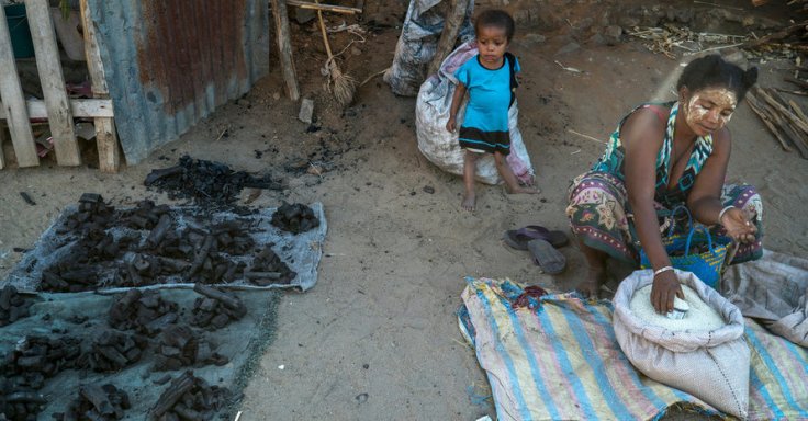
In Madagascar, the booming charcoal business is contributing to deforestation and may exacerbate the effects of global warming.

Source: www.nytimes.com

Deforestation does not happen in a vacuum–it occurs in an economic, political, and historical context.  Rural Africans have less access to high value commodities and converting forests into charcoal is one of the few options (similar to the issue in Haiti).  The short-term economic gain for a few individuals leads to long-term environmental problems such as soil erosion, flooding, and habitat destruction for many species.  


Tags: biogeography, environmentecology, poverty, development, economic, labor, Madagascar, erosionAfrica, resourcespolitical ecology.

Why I make cartograms with second graders

“There are few sights more heartening than that of an elementary school whose classrooms and hallways are decorated with world maps. Yet teachers should be careful to make sure that the standard depiction of the world map is not the only map their students encounter. Otherwise, they run the risk that children will assume ‘this is the way the world looks,’ rather than the more complicated reality that ‘this is one of many ways of representing our world.’ One useful antidote to this way of thinking is for students to explore cartograms, which are maps that use the relative area of places to present statistical data.  Please check out my cartogram lesson plan.”

Source: populationeducation.org

I love this post because it shows that–adjusting for mathematical proficiency and cartographic skill–just about any group of students can work on projects to work with data and explore various ways of how to represent that data.  


Tagseducation, K12geography education, statistics, spatial, mapping. 

Aerial Photos Show how Apartheid Still Shapes South African Cities

An American used drones to capture the color lines still stark in South African cities.

Source: www.citylab.com

In some respects this isn’t surprising, but it is still striking to see how stark the differences are.  One generation of political change does not reverse generations of systemic racism that have had economic, cultural, and political impacts.  Many of the urban planning decisions were based on apartheid, and that historical legacy is still embedded landscape.


Tags: South Africa, images, Africarace, ethnicityneighborhood, urban, planning, images, remote sensing.

Why the US government wants Americans to eat more cheese

The USDA said today that it will buy $20 million worth of cheese to donate to food banks and pantries in an effort to help America’s struggling dairy producers.

Source: www.csmonitor.com

Do politics, economics, and government policies help to shape agriculture patterns?  Absolutely.  This is an interesting, current example that shows how Chinese and Russian policies are impacting American dairy producers, and how the U.S. government is stepping in. 


Questions to Ponder:  Should the U.S. government protect businesses that are in dire straits?  What would happen if the government did not offer agricultural subsidies/bailouts?  What will happen (or not happen) because of these subsidies/bailouts?  Any way you slice it, 11 million tons is a lot of cheddar.     


Tags: agriculture, food production, economicfood, agribusiness,

The Depths of the Unseen Ocean

“The depths below the ocean’s surface comprise a staggering 95 percent of the Earth’s living space, and much of it is unexplored by humans. To put into perspective just how deep the oceans go, this XKCD comic, (hi-res image).  Most of the ocean doesn’t even see sunlight. Even scientists aren’t familiar with everything that’s down there.”

Source: www.sciencealert.com

XKCD is a comic strip that deals with many intellectual issues, but it can also be a wealth of quality scientific information.  This infographic on the oceans is staggering.


Tags: XKCD, artinfographic, physical, environmentwater.

FARC-Colombia peace deal finalized

Negotiators seeking to end the insurgency in Colombia, one of the world’s longest-running conflicts, said they had reached a final peace deal.

Source: www.cnn.com

Farclandia has long been an insurgent state where the Colombian government had no real power to enforce the rule of law and their sovereignty over this area that all the political maps say are Colombia.   This shadowy place became a place where drug cartels could operate freely and many of the concessions that Colombia is making for this deal to happen involve amnesty for past crimes. 


TagsSouth America, Colombiapoliticalnarcotics. conflict.

Map Men: teaching geography through comedy

Mark Cooper-Jones and Jay Foreman, the Map Men, tap into a rich vein of geographical quirks to teach through comedy

Source: geographical.co.uk

Why am I just now finding out about this resource?!?  This new YouTube channel is full of promise for geography teachers…fun, quirky, full of interesting trivia, but most importantly, these videos are rooted in geographic concepts. 


Tags: mappingfun, videoAPHG, geography education, unit 1 GeoPrinciples.

The 20 Most Bike-Friendly Cities on the Planet

Investment in bicycle infrastructure is a modern and intelligent move. Many cities get this. Many don’t.


Tags: urbanplace, transportationplanning, urbanism, architecture.

Source: www.wired.com

Katahdin Woods and Waters National Monument

//cdn.embedly.com/widgets/media.html?src=https%3A%2F%2Fplayer.vimeo.com%2Fvideo%2F180047331&wmode=opaque&url=https%3A%2F%2Fvimeo.com%2F180047331&image=https%3A%2F%2Fi.vimeocdn.com%2Fvideo%2F588145027_1280.jpg&key=359ed8ab27db4f02a128049b1f89d6a1&type=text%2Fhtml&schema=vimeo

“President Barack Obama designated tens of thousands of acres of Maine forest as a national monument on Wednesday, one day before the 100th anniversary of the National Park Service.  The area, known as the Katahdin Woods and Waters National Monument, spans 87,500 acres of the state’s stunning northern woods. The area is named for Mount Katahdin, which is Maine’s highest mountain and is located within the adjacent Baxter State Park.”


Tags: conservation, physical, biogeography, environment.

Source: vimeo.com

Blog at WordPress.com.

Up ↑