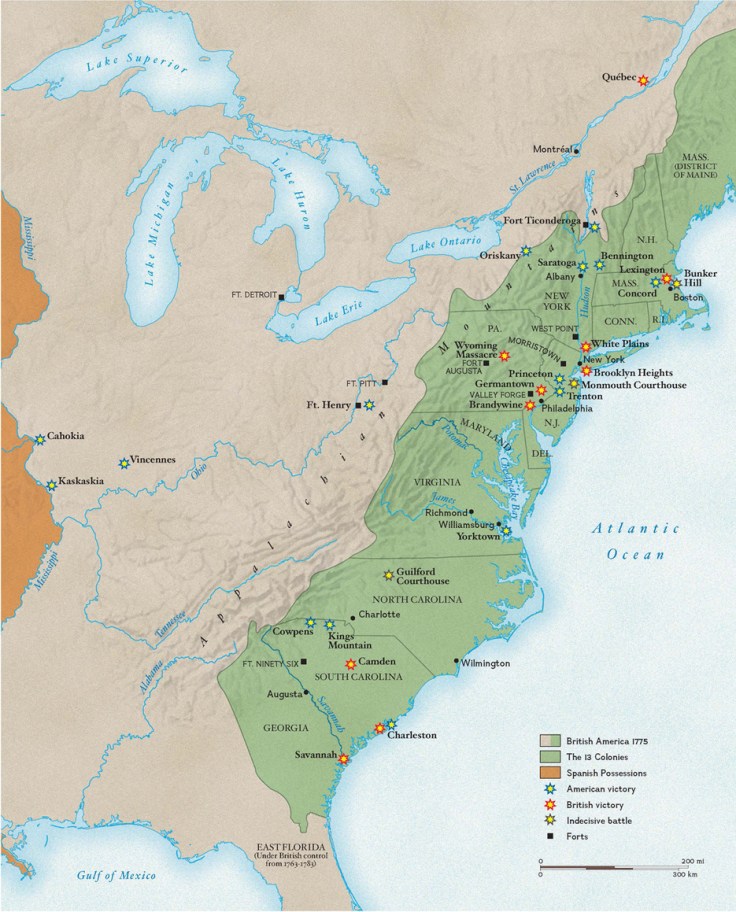
America’s war for indpendence began on April 19, 1775, when the first shots were fired at Lexington and Concord in Massachusetts.
Tags: USA, historical, mapping, National Geographic.
Source: education.nationalgeographic.com
America’s war for indpendence began on April 19, 1775, when the first shots were fired at Lexington and Concord in Massachusetts.
Tags: USA, historical, mapping, National Geographic.
Source: education.nationalgeographic.com
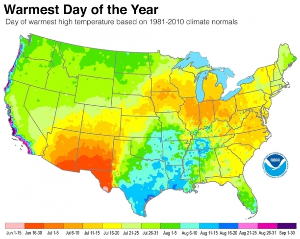
A new analysis shows when summer reaches peak heat across the U.S.
Tags: physical, weather and climate, seasonal.
Source: www.climatecentral.org
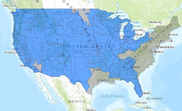
This interactive map, produced by University of Georgia historian Claudio Saunt to accompany his new book West of the Revolution: An Uncommon History of 1776, offers a time-lapse vision of the transfer of Indian land between 1776 and 1887. As blue “Indian homelands” disappear, small red areas appear, indicating the establishment of reservations (above is a static image of the map; visit the map’s page to play with its features).
Source: www.slate.com
In the past I’ve shared maps that show the historic expansion of the United States–a temporal and spatial visualization of Manifest Destiny. The difference with this interactive is that the narrative focuses on the declining territory controlled by Native Americans instead of the growth of the United States. That may seem a minor detail, but how history is told shapes our perception of events, identities and places.
Tags: USA, historical, mapping, visualization.
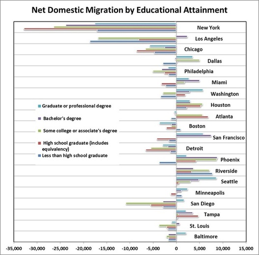
Cities like Washington and San Francisco are gaining the highly skilled but losing their less-educated workforce.
Source: www.citylab.com
This article, with its charts and interactive maps, is worth exploring to show some of the important spatial patterns of internal migration. It’s not hard to realize that larger, cosmopolitan metro areas will have an advantage in attracting and keeping prospective college graduates; the question that we should be asking our students is how will this impact neighborhoods, cities and regions?
Via Scoop.it – Geography Education
Rick Santorum, by taking on “blue” big cities, is also criticizing the Republicans, his own party.
The 2012 election are showing again some of the cultural, political and economic divides that exist in the United States. This above map portrays the 2008 presidential election, with counties that voted for McCain in red and Obama in blue. Rick Santorum has said, in reference the political map of the United States today, “Think about it, look at the map of the United States…it’s almost all red except around the big cities.” Santorum has dismissed GOP candidates successes as less meaningful because these victories took place in major cities. This political portray is an attempt to accentuate the difference between rural and urban America to hit his key demographic, but it also begs for further analysis into the electoral geography of the United States. The next map is a cartogram that shows the same counties, but weights the size of the county by population instead of territory.

As social media critic Jesse Lasler has retorted, “It’s all blue except where nobody lives.” Each perspective biases one region, as more quintessentially American, than the other. Do you see Urban America as mainstream America, or Rural America as the Heartland and the soul of what it means to be an American? What accounts for the sharp political differences between these two core components of the United States? For more maps, see this collection of 2008 election maps that shed light on the spatial voting patterns.

This graphic, via Andy Baker, highlights these demographic patterns. However, it shows that while ‘swing states’ will be the key talking points as the election gets closer, the more important ‘swing’ region in the polarized rural/urban dichotomy, will probably be the suburbs as stated in this political geography blog.


