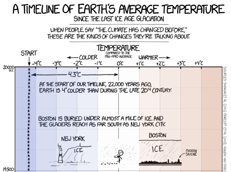
Search

GEOGRAPHY EDUCATION

Supporting geography educators everywhere with current digital resources.

Tag

environment

Earth Temperature Timeline

Source: xkcd.com

This infographic is a fascinating way to put into context the very recent trend of rising global temperatures.  This is worth scrolling all the way through to make the ending all the more meaningful.  Oh yeah, and August 2016 was the hottest month in recorded history…only 11 months of record-breaking temperatures.  


TagsXKCD, artinfographic, physicalhistorical, environment, climate change.

The Real Reason Leaves Change Color In the Fall

Tags: environmentbiogeography.

Source: www.youtube.com

Dakota Access Pipeline: What You Need to Know

Conflict between Native American protesters and private security personnel over construction of the Dakota Access Pipeline has turned violent. What is the Dakota Access Pipeline?


Tags: industryconflict, economic, energy, resources, environmentindigenous, ecology.

Source: blog.education.nationalgeographic.com

Africa’s Charcoal Economy Is Cooking. The Trees Are Paying.

In Madagascar, the booming charcoal business is contributing to deforestation and may exacerbate the effects of global warming.

Source: www.nytimes.com

Deforestation does not happen in a vacuum–it occurs in an economic, political, and historical context.  Rural Africans have less access to high value commodities and converting forests into charcoal is one of the few options (similar to the issue in Haiti).  The short-term economic gain for a few individuals leads to long-term environmental problems such as soil erosion, flooding, and habitat destruction for many species.  


Tags: biogeography, environmentecology, poverty, development, economic, labor, Madagascar, erosionAfrica, resourcespolitical ecology.

The Depths of the Unseen Ocean

“The depths below the ocean’s surface comprise a staggering 95 percent of the Earth’s living space, and much of it is unexplored by humans. To put into perspective just how deep the oceans go, this XKCD comic, (hi-res image).  Most of the ocean doesn’t even see sunlight. Even scientists aren’t familiar with everything that’s down there.”

Source: www.sciencealert.com

XKCD is a comic strip that deals with many intellectual issues, but it can also be a wealth of quality scientific information.  This infographic on the oceans is staggering.


Tags: XKCD, artinfographic, physical, environmentwater.

Katahdin Woods and Waters National Monument

//cdn.embedly.com/widgets/media.html?src=https%3A%2F%2Fplayer.vimeo.com%2Fvideo%2F180047331&wmode=opaque&url=https%3A%2F%2Fvimeo.com%2F180047331&image=https%3A%2F%2Fi.vimeocdn.com%2Fvideo%2F588145027_1280.jpg&key=359ed8ab27db4f02a128049b1f89d6a1&type=text%2Fhtml&schema=vimeo

“President Barack Obama designated tens of thousands of acres of Maine forest as a national monument on Wednesday, one day before the 100th anniversary of the National Park Service.  The area, known as the Katahdin Woods and Waters National Monument, spans 87,500 acres of the state’s stunning northern woods. The area is named for Mount Katahdin, which is Maine’s highest mountain and is located within the adjacent Baxter State Park.”


Tags: conservation, physical, biogeography, environment.

Source: vimeo.com

Bangladesh’s Hazardous Geography

Bangladesh is exposed to threat of hazards resulting from a number of natural disasters and remains classified as one the most vulnerable countries. Majority of the country is affected by cyclone, drought and floods.

Source: www.saarc-sadkn.org

Bangladesh is regularly hit with different types of natural disasters. The impact of these natural disasters costs the country millions making it dependent on foreign aid.  Disaster clean-up and relief aid after major floods, droughts, and hurricanes.  


Tagsdisasters, environmentBangladeshSouth Asia, development.

Louisiana in Tough Shape

Unlike the many maps we have seen that show what Florida, Boston, or some other coastal location would look like with higher sea levels, the figure above compares the iconic outline of Louisiana with the present-day outline of its dry land. An important caveat is that some of the removed areas are wetlands, meaning they are not under water all the time, but those lands are not available for most human uses (aside from fishing), so this outline warrants attention.

Source: environmentalgeography.blogspot.com

Last month I was in New Orleans, Louisiana and I’m so disheartened to know that thousands have their homes under water.  As stated in this article, “the boot is at best an inaccurate approximation of Louisiana’s true shape and, at worst, an irresponsible lie.”  To explore the issue yourself, this gorgeous interactive map pulls together some high quality source materials on a wide range of issues to look at this environmental issues of this region in a holistic manner.


Tags: environmentweather and climatecoastal, water, disasters

How over 2 feet of rain caused historic flooding in Louisiana in less than 72 hours

All-told, over 20 inches of rain fell in less than 72 hours around Baton Rouge.

Source: www.washingtonpost.com

Last month I was in New Orleans, and it rained for about 2 hours…it was staggering to see how many issues stemmed from that drainage in such a flat floodplain.  This is so much worse.  This article focuses on the weather/environmental situation, and this one on the political/human impact.


Tags: urban ecology, environmentweather and climate, water, disasters

Blog at WordPress.com.

Up ↑