Search

GEOGRAPHY EDUCATION

Supporting geography educators everywhere with current digital resources.

Tag

environment

Surging Seas Interactive Map

Global warming has raised global sea level about 8″ since 1880, and the rate of rise is accelerating. Rising seas dramatically increase the odds of damaging floods from storm surges.

Source: sealevel.climatecentral.org

This interactive map from Climate Central dramatically shows what locations are most vulnerable to sea level rise.  You can adjust the map to display anywhere from 1 to 10 feet of sea level rise to compare the impact to coastal communities.  This dynamic map lets to view other layers to contextualize potential sea level rise by toggling on layers that include, population density, ethnicity, income, property and social vulnerability.   


Tags: physical, weather and climate, climate change, environment, resources, watercoastalmapping, visualization, environment depend, political ecology.

Ecotourism in Australia

“Ecotourism strives to protect the native cultures and environments of destinations while entertaining and informing tourists of all ages. For many years people within the tourism industry have debated what destinations and practices truly qualify as ecotourism without reaching a definitive consensus.”

Source: cardinalscholar.bsu.edu

Ecotourism is an important aspect of Australia’s success. The Australian Government produced a website, that is dedicated to the tourism and ecotourism industry.  There is a debate of land claims between the Australian Government and indigenous people. The cultural difference plays a significant role in the success of ecotourism because tourists enjoy the cultural heritage. The separation has created social, political, and economic reasons to be involved or not in ecotourism. The Australian Government has developed certificates and policies to allow aborigines rights of their land.


Tags: biogeography, environmentindigenous, ecology, Australia, Oceania.

Pros and Cons of Cotton Production in Uzbekistan

“This case study considers the pros and cons of cotton production in Uzbekistan. Since the country’s independence from the Soviet Union in 1991, revenues from cotton taxation have contributed substantially to developing the industrial sector, boosting the current account, achieving energy and food-grain self-sufficiency, and buffering domestic shocks in food and energy prices. Nonetheless, some argue that the state procurement system hampers the development of the agricultural sector. Often the payments for cotton hardly cover farmers’ production costs, and the quasi mono-culture of cotton production has adversely affected environmental sustainability.”

Source: cip.cornell.edu

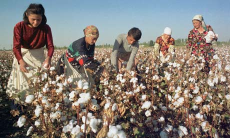
Uzbekistan is a top world producer and exporter of cotton. There are many sectors involved in managing the cotton commodity chain to partake in the production. Not only is it a source of income, but provides labor jobs and food consumption. However, the land where the cotton production takes place is suffering. This land faces many types of land degradation that has an impact on the cotton. In order to secure the land, there are possible solutions and policies to improve the agriculture and the cotton benefits. Once the world’s fourth largest lake, the Aral Sea, is located in Uzbekistan, and has had a major impact on the cotton industry. This production has given Uzbekistan a world-wide reputation in cotton production, but is also known for destroying one of the world’s largest lakes.  Just because it is your greatest economic competitive advantage, doesn’t mean that it is environmentally sustainable.


Questions to Ponder: How much does the cotton production contribute to Uzbekistan economically? What are the solutions to address the demising Aral Sea? Who is impacted the most because of the land issues?


Tags:  agriculture, labor, Uzbekistan, physical, weather and climateland use, environmentAral Sea.

How Geospatial Analytics Are Changing Habitat Conservation

“The BirdReturns program is an effort to provide ‘pop-up habitats’ for some of the millions of shorebirds, such as sandpipers and plovers that migrate along the Pacific Flyway, a route that spans from Alaska to South America. Birds flying on this journey seek out the increasingly rare wetlands teeming with tasty insects to fuel their long-distance flights.  Over the last century, California’s Central Valley has lost 95% of the wetlands habitat to development, agriculture, and other land use changes. As a solution, scientists use big data, binoculars, and rice paddies.”

Source: www.youtube.com

This project combines data from satellite imagery to map surface water in California’s Central Valley, and individual bird observations to select locations that can be temporarily converted into wetlands to aid the migratory birds (for more information than the video provides about this project, read this article). 


This is a great example of using both ‘big’ geospatial data as represented by the satellite imagery and combining it with field data and actual observations to make the world a better place.  We need more decision makers that can think spatially and use geographic skills.  


Tags: physicalCalifornia, water, environmentbiogeography, remote sensing.

Cutting Haiti’s Forests

The major environmental problem facing Haiti’s biodiversity is explained, including video of tree-cutting within a national park.

Source: www.youtube.com

Deforestation does not happen in a vacuum–it occurs in an economic, political, and historical context.  Having successfully staged a slave revolution against France in 1806, they were ostracized from the global community (since the powers that be did not want to see slave rebellions or colonial uprising elsewhere) and were forced to look within for their own energy resources.  The nation’s forests were (and still are) converted into charcoal, leading to long-term environmental problems such as soil erosion, flooding, and habitat destruction for many species.  All of this increased  increased Haiti’s disaster vulnerability in the earthquake of 2010.     


Tags: Haiti, biogeography, environmentecology, video, poverty, development, economic, labor.

Yes, Yellowstone’s Roads Just Melted. No, There’s No Reason to Panic

“Last week, a major tourist thruway in Yellowstone National Park had to be shut down because the road melted. The road’s Wicked Witch of the West impression was caused by high temperatures in both the air and under the ground. Yellowstone sits atop a volcanic hotspot, and that heat helped cause the asphalt to soften and oil to well up onto the surface.”

Source: www.smithsonianmag.com

Drought Drains Lake Mead to Lowest Level

“The largest reservoir in the U.S. falls to its lowest water level in history, Nevada State Sen. Tick Segerblom introduced a bill title and issued a press release on July 8 calling for an ‘independent scientific and economic audit of the Bureau of Reclamation’s strategies for Colorado River management.'”

This week’s history-making, bad-news event at Lake Mead has already triggered lots of news stories, but almost all of these stories focus on the water supply for Las Vegas, Phoenix and California. But what about the health of the river itself?

Tags: physicalfluvial, drought, water, environment.

Source: ecowatch.com

Ethiopia’s Dam Problems

“Ethiopia is three years from completing a dam to control its headwaters, and while Egypt points to colonial-era treaties to claim the water and to stop the project, the question remains as to who own the Blue Nile.”

Source: maps101blog.com

This 7-minute Geography News Network podcast (written by Julie and Seth Dixon) touches on some key geographic concepts.  85% of the Nile’s water comes from the Blue Nile that originates in the Ethiopian highlands–it is the Blue Nile that Ethiopia has been working on damming since 2011.  The Grand Ethiopia Renaissance Dam (GERD) will be located  near the border with Sudan.  Egypt is adamantly opposed to Ethiopia’s plan and is actively lobbying the international community to stop construction on the dam, fearing their water supply with be threatened. 

Tags: Ethiopia, Africa, development. environment, water, energy, borders, political.

This 19th Century Map Could Have Transformed the West

Today’s drought-riven west would look very different if Congress had listened to John Wesley Powell

Source: www.newrepublic.com

Author of Mapping the Nation, Susan Schulten explains how western expansion failed to recognize the basic physical geographic reality of the United States–that the west is much drier than the east.  Given that much of the west, especially California, is in the midst of a severe drought, this article serves as a reminder to recognize that localized understandings of human and environmental actions are necessary.  Do you know what watershed you live in?  How does and should that impact us?   


Tags: physical, historical, California, water, environment.

Create a free website or blog at WordPress.com.

Up ↑