Search

GEOGRAPHY EDUCATION

Supporting geography educators everywhere with current digital resources.

Tag

geospatial

Satellites Are Now Cleared to Take Photos at Mailbox-Level Detail

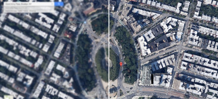
The Department of Commerce just lifted a ban on satellite images that showed features smaller than 20 inches. The nation’s largest satellite imaging firm, Digital Globe, asked the government to lift the restrictions and can now sell images showing details as small as a foot. A few inches may seem slight, but this is actually a big deal.

Source: gizmodo.com

As reported by the BBC, this change in the legal use of geospatial information could have a huge impact on many industries.  Some are fearful that it could represent an invasion of privacy, and others see this as a way to harness new satellite technology to provide higher resolution data and improved data quality for researchers. 

Tagsmappingimages, remote sensing, geospatial.

Sustaining Seven Billion People

“With seven billion people now living on Earth, the ever growing demand is putting unprecedented pressure on global resources—especially forests, water, and food. How can Earth’s resources be managed best to support so many people? One key is tracking the sum of what is available, and perhaps nothing is better suited to that task than satellites.”

Source: earthobservatory.nasa.gov

Agricultural production is one of the ways in which people modify the environment more than any other.  Global population is expected to top out at around 9 billion around 2050, so will we be able to sustainably feed all of the entire human population?  Satellite imagery can help answer these questions. 

Tagsremote sensing, geospatial, images, sustainability, agriculture, food production, environment modify, unit 5 agriculture

NASA and the World Cup

“NASA goes to the World Cup! Satellite imagery from each country playing.”

Source: www.arcgis.com

Not that we need any extra incentive to view NASA’s gorgeous satellite imagery, but now that the World Cup has entered the knockout rounds, it is the perfect opportunity to view selected images from the participating countries.  This gallery of a dozen World Cup StoryMaps are but a few of the thousands of Esri StoryMaps that can serve as motivation to get your K-12 U.S. school an organizational account for ArcGIS online (then your students can make cool maps like these). 


Tags: sport, Brazil, South America, Esri, fun, mapping, remote sensing, geospatial, images, perspective.

Why Map Projections Matter

This is a clip from the TV show West Wing (Season 2-Episode 16) where cartography plays a key role in the plot.  In this episode the fictitious (but still on Facebook) group named “the Organization of Cartographers for Social Justice” is campaigning to have the President officially endorse the Gall-Peters Projection in schools and denounce the Mercator projection.  The argument being that children will grow up thinking some places are not as important because they are minimized by the map projection.  While a bit comical, the cartographic debate is quite informative even if it was designed to appear as though the issue was trivial.

Questions to Ponder:  Why do map projections matter?  Is one global map projection inherently better than the rest?

Tags: Mapping, geospatial, video, visualization.

See on www.youtube.com

10 Places You’re Not Allowed to See on Google Maps

Via Scoop.itGeography Education

Google maps brings the world to your desktop – well, most of it, anyway. Here are 10 locations that governments and other entities have blurred or removed from satellite photos.

A user of geospatial technologies is not free to explore all places of the Earth with equal levels of specificity. Why?  Where? How come?

Via mashable.com

Stratocam: Google Earth Imagery

Via Scoop.itGeography Education

Explore and vote on the best Google Maps satellite imagery around the world.

Much like sites that you can rate items up or down, you can rate the best aerial photography via Google Earth screen shots.  There are some beautiful images and places to be discovered through this site.  The physical and human landscapes are both intermingled in this fantastic collection of images…be careful, it can be amazingly addictive.  For more from the producer of this site, see: http://paulrademacher.com or follow on twitter @paulrademacher.

Some of my personal additions to this gallery include the Paseo de la Reforma sector of Mexico City, Hamburg, Germany, Venice, Italy, Cape Cod, MA, Drumlin city of Friedrichshafen-Raderach in Southwest Germany, a meteor create lake, Pingualuit Lake in Northern Quebec, the Angkor Wat complex in Cambodia, the Great Salt Lake, UT, Citadella, Italy, Mexican Hat, Utah, Mesa Verde National Park, Colorado (zoom out for a fire-ravaged image) and the “Twelve Apostles” in Australia.

Via www.stratocam.com

GPS technology maps land rights for Africa’s ‘forest people’

Via Scoop.itGeography Education

In the lush rainforests of Africa’s Congo Basin, hundreds of thousands of indigenous people live as hunter gatherers, depending on the forest’s natural resources for their survival.

The “Mapping for Rights” program trains people in the Congo to map the land they live on using GPS and other geospatial technologies.  This can assist the to produce documents to politically protect their land from encroachment and preserve their access to the forest.  Globalization can blur many of the modern/traditional narratives as the world becomes interconnected in complex ways.

Via edition.cnn.com

QGIS

Via Scoop.itGeography Education

Do you want to use GIS but don’t have the budgetary support to install expensive software?  Don’t know where to start?  QGIS is a free, open-source GIS that is a nice option for schools operating on a limited budget that still want a full GIS platform.

For GIS novices, here is an excellent set of video screencasts that are an introduction to what GIS is, using the QGIS software. This site also provides sample data, tutorials and worksheets.

Another excellent tutorial for novices to GIS is found here.   This tutorial was especially designed for journalists creating maps, and walks you through the installation process as well as some of the basics of the user interface.

Many small city governments without the budget to run proprietary GIS software use QGIS and here is a repository of QGIS resources including blogs, forums, tutorials and user manuals.  An excellent blog with QGIS tutorials is: http://qgis.spatialthoughts.com/

Via qgis.org

Geospatial mapping enhances Arlington National Cemetery management

Via Scoop.itGeography Education

Officials at Arlington National Cemetery will use an Army-designed geospatial mapping system to manage cemetery operations, the executive director of the Army National Cemeteries Program said March 8, 2012.  

This is another fantastic example of how GIS, GPS and online mapping can be used within many diverse projects.  Mapping cemeteries can be an excellent service learning project for a GIS class and the exploring local cemeteries is a very hands on method for exploring local history in a way that makes place matter. Geographic skills and spatial analysis is increasingly critical in the 21st century as we’ve seen an explosion of online applications for geospatial technologies.
Via www.army.mil

Blog at WordPress.com.

Up ↑