Search

GEOGRAPHY EDUCATION

Supporting geography educators everywhere with current digital resources.

Tag

historical

Five ways China’s past has shaped its present

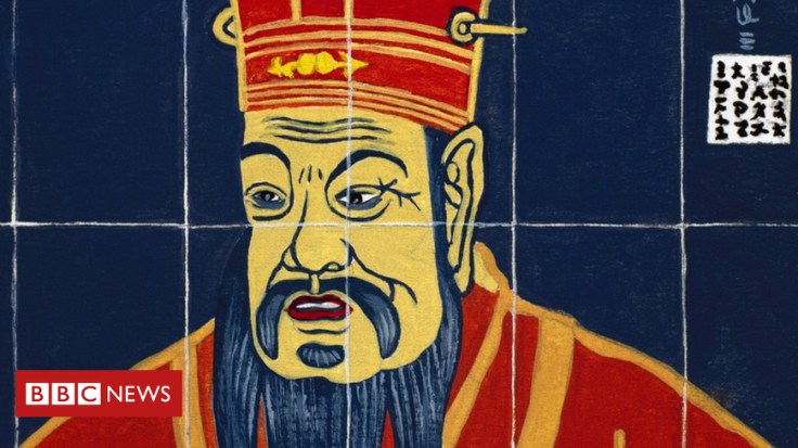
“The country is perhaps more aware of its own history than any other major society on earth. That remembering is certainly partial – events like Mao’s Cultural Revolution are still very difficult to discuss within China itself. But it is striking how many echoes of the past can be found in its present.”

Source: www.bbc.com

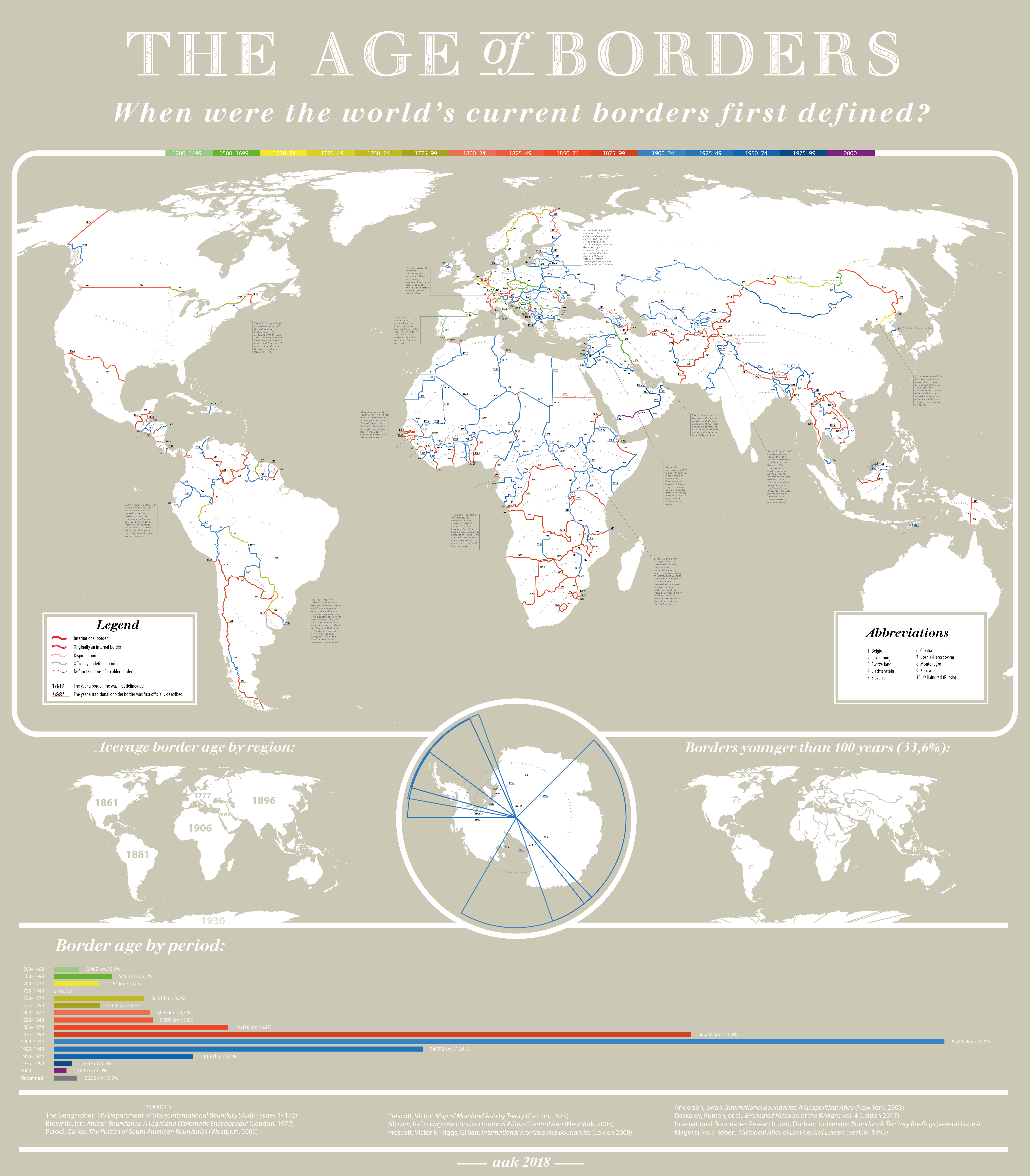
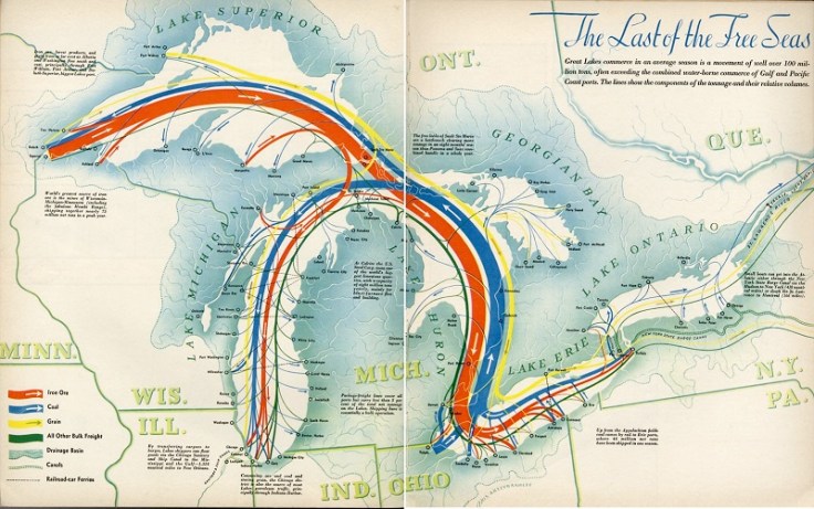
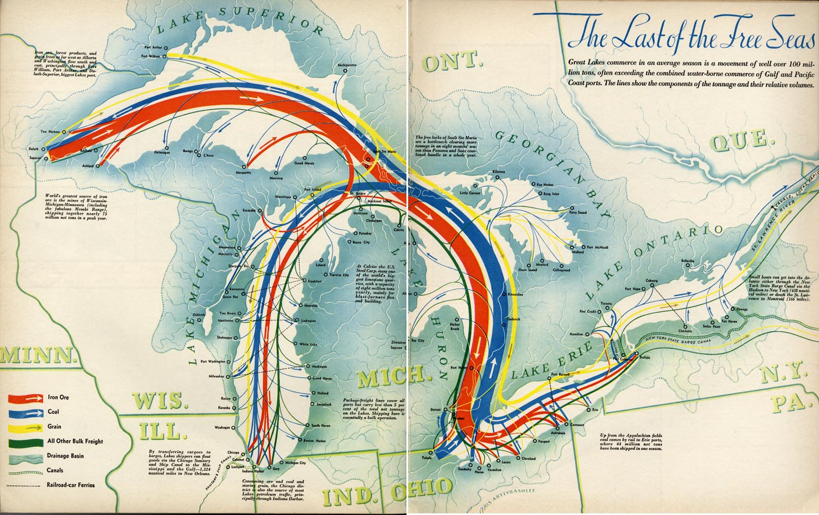
This is a very interesting article…one can make too much of a country’s history as a casual factors, and yet make too little of historical patterns at your own peril.  “To understand China’s approach today to trade, foreign policy or censorship, consider its history.”  This article considers a few of  China’s current policies that may seem peculiar today but that make much more sense with a longer and deeper history.  Some of the topics considered include:

  • trade
  • trouble with neighbors
  • Information flow
  • Religious freedoms
  • Technology


Tags: China, East Asia, historical.

The Age of Borders

The creation date of (almost) every international border.  Full-size image here.


Tags: infographic, worldwide, borders, political, historical.

Source: c1.staticflickr.com

The Two Koreas

“While the Korean War of the early 1950s never formally ended, its aftermath has created starkly divergent worlds for those living on either side of the north-south divide. What follows is a look at life in the two Koreas; how such a night-and-day difference came to be; and where the crisis could go from here. Both governments claimed to be the legitimate rulers of the peninsula. Tensions between north and south gradually mounted, until finally, in June 1950, hundreds of thousands of North Korean troops stormed across the 38th parallel. The unsuspecting South Korean defenders were outgunned and outnumbered, and beat a hasty retreat southward.”

Source: storymaps.esri.com

This excellent interactive was created by Esri’s Story Maps team using the Story Map Cascade app–making it an great resources of the geography of the Korean Peninsula as well as a stellar example of how maps, infographics, videos, images and text can be combined using ArcGIS online.


Tags: mappingESRIStoryMapinfographic, visualizationNorth KoreaSouth Korea, East Asiaborders, political, geopolitics, historical.

Story Map Swipe and Spyglass Gallery

“The Story Map Swipe and Spyglass app template enables users to interact with two web maps or two layers of a single web map, depending on how you build your story. The app enables you to present a single view, or to develop a narrative showing a series of locations or views of the same maps.”

Source: storymaps.arcgis.com

The ESRI template to create swipe and spyglass feature is an engaging way to compare and contrast two data layers. For the SPYGLASS maps, I’ve always enjoyed this historical interactive of Chicago. Chicago is displaced during a economic boom period as the U.S. was expanding westward.  Where were the railroads located then?  Why have some of them vanished today?  Notice anything curious about the coastline along Lake Michigan?  Follow this link to see similar interactives of other major U.S. cities.

For the SWIPE maps, I love exploring this one showing how human activities has reshaped the physical environment.  What activities are creating the new patterns that you see?


Tags: historical, mapping, ESRI, StoryMap.

How the letters of the alphabet got their names

There seems to be little predictability to the English names for the letters of the alphabet, to say nothing of the names of letters in other languages. Some begin with an e-as-in-egg sound (eff, ell); some end in an ee sound (tee, dee); and others have no obvious rhyme or reason to them at all. How did they get that way?


Tags: language, culturehistorical, English.

Source: www.economist.com

Capital Jerusalem

“Because Israel refused to recognize the U.N. plan for an internationalized Jerusalem and because of its annexation of occupied East Jerusalem in 1967, no country in the world has offered legal and diplomatic recognition of Jerusalem as the capital of Israel. Most states, however, have unofficially acknowledged Israel’s sovereignty and actual possession, without recognition of lawful title.”

Source: beitemmett.blogspot.com

That is, until now.  The United States is planning to move it’s embassy from Tel Aviv to Jerusalem, in a move that will have far more reaching implications than the relocation of just about any other embassy on Earth could have, given the geopolitical significance of Jerusalem to the Israeli-Palestinian conflict and the broader international ties.  Below are some resources to contextualize this shift: 


Questions to Ponder: How does this change the status quo at the local, national and international scales?  What might be some of the consequences of this move?  What would you recommend and why?  


Tags: Israel, Palestine, borders, political, Middle East, geopolitics, historical.

The American West, 150 Years Ago

In the 1860s and 70s, photographer Timothy O’Sullivan created some of the best-known images in American History. After covering the U.S. Civil War, (many of his photos appear in this earlier series), O’Sullivan joined a number of expeditions organized by the federal government to help document the new frontiers in the American West. The teams were composed of soldiers, scientists, artists, and photographers, and tasked with discovering the best ways to take advantage of the region’s untapped natural resources. O’Sullivan brought an amazing eye and work ethic, composing photographs that evoked the vastness of the West. He also documented the Native American population as well as the pioneers who were already altering the landscape. Above all, O’Sullivan captured — for the first time on film — the natural beauty of the American West in a way that would later influence Ansel Adams and thousands more photographers to come.


Tags: images, artlandscape, tourism, historicalUSA.

Source: www.theatlantic.com

“The Last of the Free Seas”

“The Last of the Free Seas is the title of this fantastic map of the Great Lakes made by Boris Artzbasheff.  It was published in Fortune Magazine in July 1940.”

Source: www.reddit.com

The inland waterways were absolutely critical to the demographic and economic development of the eastern part of the United States, especially from 1820-1940.  Before World War II, Great Lakes shipping exceeded the tonnage of U.S. Pacific Coast shipping (see hi-res map here). World War II and the beginning of the Cold War led to a consolidation of naval power for the United States and its allies, greatly expanding Pacific shipping trade and spurring fast-developing economies countries. 


Great Lakes shipping dramatically declined, in part because steel production has gone to lower-cost producers that were connected to the U.S. economy through the expanded trade.  Some could see irony since the steel warships created from the Great Lakes manufacturing enabled expanded Pacific and Atlantic trade that led to the decline of Great Lakes manufacturing and regional struggles in the rust belt.  Still, more than 200 million tons of cargo, mostly iron ore, coal, and grain, travel across the Great Lakes annually.


This deindustrialization clearly is a huge economic negative but the environmental impacts for lakeside communities has been enormous.  Industrial emissions in the watershed and shipping pollution in the lakes went down as waterfowl populations returned and more waterfront property became swimmable again.  Still this map of the environmental stress on the Great Lakes shows they are far from pristine.    


Tagsenvironment, historicalwater, resources, transportation, industry, economicregions, globalization.


Esri GeoInquiriesâ„¢ for World History

“The Esri Education Outreach team is pleased to announce the release of a sample pack from the forthcoming GeoInquiries™ collection for World History classrooms.  The sample pack includes the first four activities supporting high school World History instruction with ArcGIS Online.  Eleven additional activities will be released over the coming weeks.”

Source: education.maps.arcgis.com

ESRI has produced GeoInquires for Earth Science, US History, Environmental Science, AP Human Geography, 4th grade, and has recently released a now has a set for World History.

Tagsmappinggeospatialempire, historical, ESRI, K12, edtech.

Create a free website or blog at WordPress.com.

Up ↑