Search

GEOGRAPHY EDUCATION

Supporting geography educators everywhere with current digital resources.

Tag

physical

The Autumnal Equinox

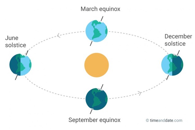
“In the Northern Hemisphere, the fall equinox marks the first day of fall (autumn) in what we call astronomical seasons. There’s also another, more common definition of when the seasons start, namely meteorological definitions, which are based on average temperatures rather that astronomical events.  Equinoxes are opposite on either side of the equator, so the autumnal (fall) equinox in the Northern Hemisphere is the spring (vernal) equinox in the Southern Hemisphere and vice versa.”


Tags: Sunseasonal, space.

Source: www.timeanddate.com

Earth Temperature Timeline

Source: xkcd.com

This infographic is a fascinating way to put into context the very recent trend of rising global temperatures.  This is worth scrolling all the way through to make the ending all the more meaningful.  Oh yeah, and August 2016 was the hottest month in recorded history…only 11 months of record-breaking temperatures.  


TagsXKCD, artinfographic, physicalhistorical, environment, climate change.

Sinkhole looks like an abyss, recharges aquifer

At this sinkhole, about 500 cubic feet of water per second is disappearing into the earth, the equivalent of an Olympic-sized swimming pool every three minutes, according to an engineer with the Edwards Aquifer Authority. For as much water reaches the aquifer at this spot, far more infiltrates through porous rock across South-central Texas.

Source: www.mysanantonio.com

Not all water runoff goes to rivers, lakes, and oceans.  Some water percolates into soils that can absorb water (aquifers) but there are some soils such as clay that can’t absorb water (aquicludes or aquitards).  In this dramatic example (see video), the water is not absorbed by the resistant rock, flows through a sinkhole to recharge the aquifer below.    


Tags: physical, geomorphologywater, erosion.

Death Valley’s Roving Rocks

Death Valley,California – Giant boulders in the desert look as though their moving all on their own! But could weird weather be behind these roving rocks

Source: www.youtube.com

Since the video above was created, the mystery has been solved.  On very rare occasions, when it rains in the region, water will accumulate in the playa (discovermagazine.com).  If the wind is powerful and consistent enough, the wind will push the panels of ice against these rocks and over time, the ice floes will push these rocks, leaving behind distinctive trails (latimes.com). This perfect combination of water, wind, ice and heat creates a remarkable signature on the landscape (livescience.com).  The video in this article (weather.com) nicely explains how the non-aerodynamic rocks of Death Valley’s Racetrack Playa move, leaving behind their trail in the hot desert.  Numerous attempts using GPS receivers (NatGeo.com) and good ol’ fashioned observations have been made, but observing ice in Death Valley is so rare that no one had ever seen it until now (phys.org).  


Tags: physical, geomorphology, landforms, desertlandscape.

The Depths of the Unseen Ocean

“The depths below the ocean’s surface comprise a staggering 95 percent of the Earth’s living space, and much of it is unexplored by humans. To put into perspective just how deep the oceans go, this XKCD comic, (hi-res image).  Most of the ocean doesn’t even see sunlight. Even scientists aren’t familiar with everything that’s down there.”

Source: www.sciencealert.com

XKCD is a comic strip that deals with many intellectual issues, but it can also be a wealth of quality scientific information.  This infographic on the oceans is staggering.


Tags: XKCD, artinfographic, physical, environmentwater.

Katahdin Woods and Waters National Monument

//cdn.embedly.com/widgets/media.html?src=https%3A%2F%2Fplayer.vimeo.com%2Fvideo%2F180047331&wmode=opaque&url=https%3A%2F%2Fvimeo.com%2F180047331&image=https%3A%2F%2Fi.vimeocdn.com%2Fvideo%2F588145027_1280.jpg&key=359ed8ab27db4f02a128049b1f89d6a1&type=text%2Fhtml&schema=vimeo

“President Barack Obama designated tens of thousands of acres of Maine forest as a national monument on Wednesday, one day before the 100th anniversary of the National Park Service.  The area, known as the Katahdin Woods and Waters National Monument, spans 87,500 acres of the state’s stunning northern woods. The area is named for Mount Katahdin, which is Maine’s highest mountain and is located within the adjacent Baxter State Park.”


Tags: conservation, physical, biogeography, environment.

Source: vimeo.com

Interactive Climate Map

“Obsessed as we are with cartography we in Staridas Geography perceive any aspect of the actual 3D World as a constant opportunity for another pretty map creation!”

Source: staridasgeo.maps.arcgis.com

This is a great interactive map of the world’s climate zones. 


Tags: ESRIStoryMapedtech, GIS, mapping, cartographyphysical.

Surging Seas Interactive Map

Global warming has raised global sea level about 8″ since 1880, and the rate of rise is accelerating. Rising seas dramatically increase the odds of damaging floods from storm surges.

Source: sealevel.climatecentral.org

This interactive map from Climate Central dramatically shows what locations are most vulnerable to sea level rise.  You can adjust the map to display anywhere from 1 to 10 feet of sea level rise to compare the impact to coastal communities.  This dynamic map lets to view other layers to contextualize potential sea level rise by toggling on layers that include, population density, ethnicity, income, property and social vulnerability.   


Tags: physical, weather and climate, climate change, environment, resources, watercoastalmapping, visualization, environment depend, political ecology.

Live chart: Fish stocks

“The world’s fish are in danger—as is everyone who depends on them.”

Source: www.youtube.com

Every semester I share with my students this New York Times video about the rapid rise in industrial fishing and the production of Talapia.  Even with the rise of aquaculture as a major source of seafood, the world’s oceans are still depleted.  As the world’s population rises, many folk cultures with their roots in small fishing villages have transformed into primarily urban societies, but these urban societies still have a strong cultural preference for seafood and consume at levels that are not sustainable.    


Tags: environment modifyfolk culturesconsumption, water, physical.

Create a free website or blog at WordPress.com.

Up ↑