Search

GEOGRAPHY EDUCATION

Supporting geography educators everywhere with current digital resources.

Tag

planning

Braves’ New Ballpark Is An Urban Planner’s Nightmare 

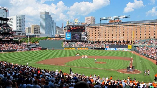
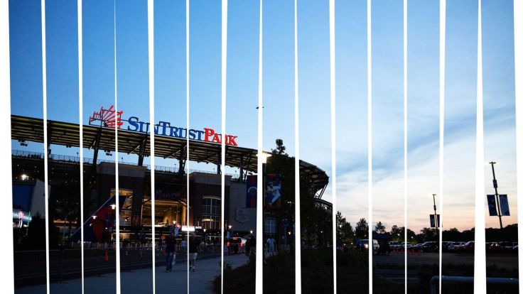
“The Braves chose to relocate to Cobb County from downtown Atlanta’s Turner Field after only 19 years because of a $400 million public subsidy from Cobb taxpayers. The costs are almost certain to balloon thanks to some significant fiscal buffoonery on the part of Cobb officials, including a lack of a comprehensive transportation plan and forgetting to ask the Braves to pay for traffic cops. Attached to SunTrust Park like a Cinnabon-scented goiter is the Battery Atlanta, a $550M mixed-used development that looks an awful lot like a New Urbanist project, the widely criticized school of planning that is equal parts social engineering and neoliberalism. SunTrust isn’t solely accessible by car—the Braves run a stadium shuttle bus that serves a couple of outer MARTA stations—but, compared to the team’s former home, the non-motorized options are paltry.”

Source: deadspin.com

There are many great geography angles to look at this particular issue.  The scale of governance matters in creating the political context for any given situation.  In this article, we see City vs. County vs. Metropolitan regional politics jockey for position, putting the interest of their own county above that of the larger metropolitan region.  We also see competing visions of ideal urban planning (a more sprawling, automobile-centered model vs. public transit, multi-use planning that is enclosed vs. open) all layered upon racial and socio-economic context of this particular place.   


Tagsarchitecture, scale, sport, urban, planning, urbanism, economic.

When Climate Change Meets Sprawl: Why Houston’s ‘Once-In-A-Lifetime’ Floods Keep Happening

But a local understanding of place is critical and this viral post–Things non-Houstonians Need to Understand–is pretty good.

“Unchecked development remains a priority in the famously un-zoned city, creating short-term economic gains for some, but long term flood risk for everyone.”

Source: projects.propublica.org

Houston’s development boom and reduction of wetlands leave region prone to more severe flooding.  Here is a great map of the change in impervious surfaces in the region from 1940 to 2017–when you combine that with record-breaking rainfall the results are catastrophic.  But a local understanding of place is critical and this viral post–Things non-Houstonians Need to Understand–is pretty good.   

Tags:  physical, fluvial, water, coastal, urban, planning, transportation, architecture.

The walkable city

How do we solve the problem of the suburbs? Urbanist Jeff Speck shows how we can free ourselves from dependence on the car — which he calls “a gas-belching, time-wasting, life-threatening prosthetic device” — by making our cities more walkable and more pleasant for more people.

Source: www.ted.com

In the 2017 APHG exam, there was a question that dealt with new urbanism and walkability.  This TED talk from Jeff Speck gives a good sense of what planners believe in new urbanism are trying to do (you can also watch his earlier TED talk, 4 ways to make a city more walkable). Here also is information on New Urbanism (dot org) from it’s practicioners, such as the Congress on New Urbanism.  Lastly, here is an academic article reviewing the critiques of new urbanism with rebuttals.    


Tagsplace, neighborhood, urban, planningtransportation, urbanism, scale, TED, video.

Mapping Coastal Flood Risk Lags Behind Sea Level Rise

Federal maps help determine who on the coast must buy flood insurance, but many don’t include the latest data. Maryland is now making its own flood maps, so homeowners can see if they’re at risk.

Source: www.npr.org

Geographic themes are overflowing (it was an unintended pun, but I’ll just let that wash over you) in this podcast.  I suggest playing a game early in the year/semester called “find the geography.”  What geographic theme/content areas will your students find in this podcast? 


Tagspodcast, mapping, cartography, climate change, environment, watercoastal,  urban, planningurban ecology.

Why 80% of Singaporeans live in government-built flats

Lots of countries show off their public-housing projects, but few are quite as devoted to them as Singapore, where four-fifths of the permanent population live in subsidised units built by the government, most of them as owner-occupiers. The city-state’s suburbs bristle with HDB towers, painted calming pastel hues. This vast national housing system surprises visitors who think of Singapore as a low-tax hub for expatriate bankers and big multinationals. But HDB is a linchpin of economic and social policy and an anchor for the ruling People’s Action Party (PAP), which has led Singapore since independence. It is also a tantalising but tricky model for Singapore’s fast-urbanising neighbours to follow.

Source: www.economist.com

Singapore is such a fascinating case study.  Over 90% of the Singapore’s land is owned by the government and the American ideal of independent home ownership is seen as antithetical to cultural norms.  The government heavily subsidies young couples to live near their parents and create tight-knit communities with homelessness was eradicated (that’s the optimists’ perspective).  This is all well and good for young, straight couples that choose to support the ruling political party, but critics often point out that the housing focus has also created a paternalistic component to the government that is much stronger in Singapore than in other countries.  This article nicely goes with the 2017 APHG reading professional development talk entitled “The Geographies of Home” that focused on Singaporean and Japanese examples.    


Tag: Singapore, urban, neighborhood, economicplanning, housing, cultural norms.

In the Same Ballpark

“In 1992, the Baltimore Orioles opened their baseball season at a brand new stadium called Oriole Park at Camden Yards, right along the downtown harbor. The stadium was small and intimate, built with brick and iron trusses—a throwback to the classic ballparks from the early 20th century. It was popular right from the start.

These new Populous ballparks are small and old fashioned-looking but they also feature modern amenities—comfortable seats and fancy foods. And while designed to be different, they tend to follow a similar aesthetic format, featuring a lot red brick and green-painted iron. These new parks also feature asymmetrical playing fields, which are in many cases dictated by the surrounding cityscape.”

Source: 99percentinvisible.org

This podcast is filled with important urban geographic issues: downtown revitalization, landscape aesthetics, sense of place, planning, public/private revitalization, etc.  And to boot, this podcast uses America’s pasttime to discuss these topics. I typically really enjoy the thoughtful exploration of the untold stories that make up our world found in the 99 Percent Invisible podcast.

What Rio doesn’t want the world to see

“Rio is hiding poor people. See Part II: https://www.youtube.com/watch?v=c3BRTlHFpBU

Source: www.youtube.com

This isn’t news, but it isn’t just about Rio de Janeiro, since the World Cup and Olympics have already come and gone. Yet the urban planning designed for the world’s gaze remains.  Some strategies used were to create economic development and stimulate the local communities, but more often than not, the poor of the city and the poor communities cities were swept under the rug without addressing the issues that creating poverty with the city.  Many of the poor communities closest to Olympic venues were demolished without real viable housing options for the displaced residents.


Questions to Ponder: Can you think of other ways (of other examples) that city planning is used to hide the poor or the ‘less desirable’ parts of the city?  Why does this happen?  How should urban planning approach economic redevelopment, poverty, and community?   


Tags: Brazil, urban, squatter, neighborhood, economicplanning, urbanism.


4 ways to make a city more walkable

Freedom from cars, freedom from sprawl, freedom to walk your city! City planner Jeff Speck shares his “general theory of walkability” — four planning principles to transform sprawling cities of six-lane highways and 600-foot blocks into safe, walkable oases full of bike lanes and tree-lined streets.

Source: www.ted.com

As the 2017 APHG exam has ended, some people have asked for more resources on new urbanism.  This TED talk from Jeff Speck gives a good sense of what planners believe in new urbanism are trying to do (you can also watch his earlier TED talk, The Walkable City).  Here is information from New Urbanism (dot org) from it’s practioners, including the Congress on New Urbanism.  Lastly, here is an academic article reviewing the critiques of new urbanism with rebuttals.  

Tags: place, neighborhood, urban, planning, transportation, urbanism, scale,  TED, video.

New Urbanism

New Urbanism is a planning and development approach based on the principles of how cities and towns had been built for the last several centuries: walkable blocks and streets, housing and shopping in close proximity, and accessible public spaces. In other words: New Urbanism focuses on human-scaled urban design.”

Source: www.youtube.com

As the 2017 APHG exam has ended, some people have asked for more resources on new urbanism.  Here is information from New Urbanism (dot org) the Congress on New Urbanism for teachers and students that are reassessing the Free Response Questions. 


Tagsplace, neighborhood, urban, planning, urbanism, scale

Blog at WordPress.com.

Up ↑