Via Scoop.it – Geography Education
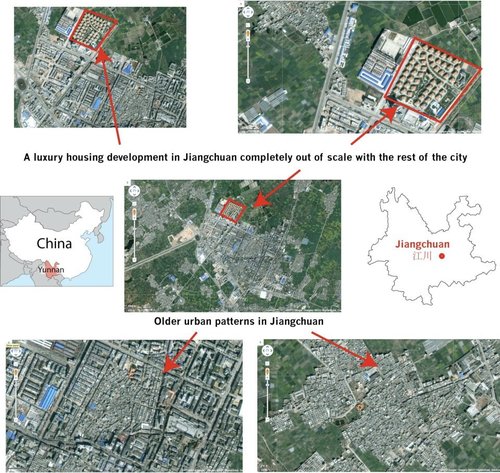
This gallery of Google Earth Screen shots primarily from Yunnan Province in Southern China (bordering Vietnam and Burma) brings some keen spatial analysis to those unfamiliar with the region. This is also a great example of using geospatial technologies to interpret the cultural landscape–the merger of ‘people and pixels’ as the textbook of the same name encourages with classrooms. While the quality of this work is above what would be expected of students, a Google Earth project designed to get students to reassess the spatial dynamics within their neighborhood or home state could lead some fantastic projects.
Via www.facebook.com
- Articles
- APHG Faculty Lectures
- Assessing the Validity of Online Sources
- Brexit: Reaction and the Aftermath
- Comparing Urban Footprints
- Geographic Imagination in the English Anthem ‘Jerusalem’
- Geography on Twitter
- Israeli-Palestinian Conflict updates, 2016
- Learning From Home
- Political and Economic Geography Presentations
- Start-of-the-Year Videos
- Strava Heat Map and National Security
- Teaching about Syrian Refugees
- Thanksgiving Resources
- The Atlas of Economic Complexity: the Case of Costa Rica
- The Geography of E-Waste
- Videos: How Does it Grow?
- California’s Drought
- Cultural Meaning in Moving Monuments
- Gerrymandering
- Navigating and Occupying Gendered Space
- Place and Flash Mobs
- Imaginary Geographies
- Older Articles
- Regional
- Thematic
- Geospatial
- Courses
- Presentations
- About


Leave a comment