Search

GEOGRAPHY EDUCATION

Supporting geography educators everywhere with current digital resources.

Month

November 2012

The Geography of Thanksgiving Foods

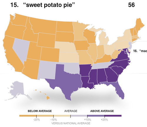
The terms cooks enter into search engines can provide clues as to what dishes are being cooked around the nation.


Some fascinating (if not entirely scientific) maps that show the most common searches on www.allrecipes.com and regional differences in food preferences.  More importantly, it also is an interesting glimpse into the geography of language.  Some similar dishes are called by more regional names (e.g.-“Stuffing” in the Northeast and West, “Dressing” in the Midwest and South).  This set of maps also reinforces the concepts of regions.  This is a fun way to teach some actual content and enjoy the holiday.

Tags: language, food, diffusion, regions, seasonal.

See on www.nytimes.com

A Barrier to Peace

“Why would they want to pull down these walls?” asks William Boyd mildly as he offers me a cup of tea in his home at Cluan Place, a predominantly Loyalist area of east Belfast.

These walls, orginally installed in the late 60s to protect Belfast residents during “the Troubles.”  Today, some argue that these walls are now barriers to the peace process as they continue defacto segregation.  Walls, as barriers to diffusion, stifle communication, cooperation and interaction.  Still, these walls are symbols of communal identity and icons in the cultural landscape.  For more academic work on this, see Peter Shirlow’s Belfast: Segregation, Violence and the City.

Questions to Consider: How would a wall through an already culturally and politically divided city impact both sides of the wall?  Today, are the walls beneficial to peace in Northern Ireland?

Tags: Ireland, states, borders, political.

See on blogs.reuters.com

GITN: Pilgrims’ Progress

This classic Geography in the News by Neal Lineback has been re-released on his Lineback World View site.  This is an excellent lesson for K-12 educators to prepare their students to understand the historic and geographic context of Thanksgiving.

See on www.linebackworldview.com

2014 World Cup: Will Brazil Be Ready?

ESPN Video: With the FIFA World Cup two years away, will Brazil be ready to host soccers premiere event?

This short sports documentary (12 minutes) looks at some of the socioeconomic and urban planning issues that are a part of the logistics for a country to prepare for a sporting event on the magnitude of the World Cup.  The discussion of demolitions in the favelas (squatter settlements) is especially intriguing.  Major sporting events of this magnitude that last for two weeks can reshape local geographic patterns for decades.  

Tags: sport, Brazil, planning, squatter.

See on espn.go.com

Pre- and Post-Storm 3D Lidar Topography

This project investigates the coastal impacts of hurricanes and extreme storms.

Here is some more post-Sandy geo-spatial imagery. LIDAR (think sonar and radar but with light and lasers) is Light Detection And Ranging that can produce some amazing data. 

See on coastal.er.usgs.gov

Africa for Norway

This website is an incredibly humorous parody of Eurocentric charitable organizations that, while well-intentioned, propogate many negative stereotypes about Africa.

Questions to Ponder: What do you think the ‘point’ of Radi-Aid is?  DO you agree with their point?  How does the media influence our idea of places?

Tags: Africa, development, NGOs, Norway.

See on www.africafornorway.no

In 2009, Engineers Detailed Storm Surge Threat to NYC

One of the nation’s most influential groups of engineers said it presented detailed warnings that a devastating storm surge in the region was all but inevitable and proposed ways to prepare.


MH: Hey, you know what? A bunch of engineers accurately predicted the kinds of damage the East Coast would face from a strong storm surge. Maybe we should give that science stuff a little consideration in our future plans in designing our cities.

See on www.nytimes.com

A Life Revealed – National Geographic Magazine

Seventeen years after she stared out from the cover of National Geographic, a former Afghan refugee comes face-to-face with the world once more.

See on ngm.nationalgeographic.com

Persuasive Maps

John F. Smith’s smartly-designed biblical anti-slavery map of the mid-19th Century United States. Prepared in 1888; excerpted from “Maps for an emerging nation”.

Maps don’t just convey information–they can also shape the way that we think about the world that is being represented by that map.  Maps are texts and sometimes they have very strong perspectives that the cartographer put into that map.  This persausive map shows one way of interpreting American history after the end of reconstruction.  Notice that in addition to the very overt religious, moral tone condemning the South for slavery, they ideas of Manifest Destiny are also woven into the fabric of this map. 

Tags: cartography, historical, USA.

See on www.bigmapblog.com

Create a free website or blog at WordPress.com.

Up ↑