On three different occasions, the candidate with the most votes didn’t become President of the United States. We call this “The Electoral College Problem.” Here a solution. Simple. Mathematical. Rational.
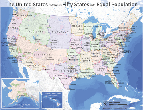
As a disclaimer, I’m not endorsing the removal of all current state borders, but I think that this is a great thought exercise that involves some serious spatial thinking and geography knowledge to create this map (or even to critique and discuss it). This map represents an attempt to restructure the states so that each state would have equal value in the electoral college with roughly equal populations (county borders remained firm). What about the physical and human geography would make some of these “states” better (or worse) than the current configuration of the 50 states? How would this ‘redistricting’ impact your local region?
Tags: political, gerrymandering, mapping, unit 4 political.
See on www.npr.org


February 27, 2013 at 9:45 am
The crazy solution to the electoral problem is not really that crazy, in that it makes mathematical sense, but I wonder if results would be that different for elections. Looking at the new version of the Electoral College with its interesting and historically relevant names and themes, equally divided up into 6+million person blocks, I can’t help but think the results for elections would not be all that much different to what we have now. The country would still exist with an urban/rural split; the divides between the South and North are not changed. Democrats might end up with even more votes; since some newly creates “states” would form new concentrations of minority/urban voting blocks. For example “Chinati” would incorporate the border areas of Texas-rural/democrat- with San Antonio a urban democrat area as well, this would dilute the larger Republican areas of Texas, thus causing the map to sway to democrats.