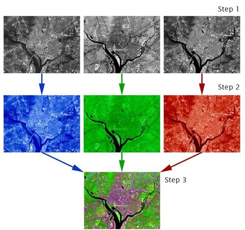
“Satellites acquire images in black and white, so how is it possible to create the beautiful color images that we see on television, in magazines, and on the internet? Computers provide us with the answer.
Images created using different bands (or wavelengths) have different contrast (light and dark areas). Computers make it possible to assign ‘false color’ to these black and white images. The three primary colors of light are red, green, and blue. Computer screens can display an image in three different bands at a time, by using a different primary color for each band. When we combine these three images we get a ‘false color image.’
Find tutorials and links to free compositing programs here.”
Tags: remote sensing, images, geospatial, unit 1 GeoPrinciples.
See on landsat.gsfc.nasa.gov


February 27, 2013 at 10:11 am
Satellite images that have been given multiple wavelengths or “false color” images show us more than basic photo, since the wavelengths that our eyes don’t see are assigned for us. In the photos shown here the treatment of the images allows urban/water/tree cover to come into better view, so these false color images actually tell us more than our “true” eyes would.