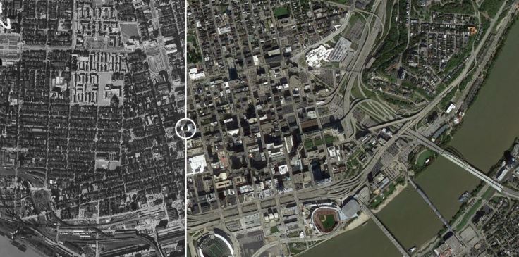
“60 years has made a big difference in the urban form of American cities. The most rapid change occurred during the mid-century urban renewal period that cleared large tracts of urban land for new highways, parking, and public facilities or housing projects. Fine-grained networks of streets and buildings on small lots were replaced with superblocks and megastructures. While the period did make way for impressive new projects in many cities, many of the scars are still unhealed. We put together these sliders to show how cities have changed over half a century. In this post, we look at Midwestern cities such as [pictured above] Cincinnati, Ohio.”
Source: iqc.ou.edu
It’s ironic that I feel more accustomed to exploring Cincinnati, OH on foot than I do Providence, RI. Although I drive in downtown Providence regularly, I seldom have a reason to walk and explore it. In my yearly visits to Cincinnati to score the AP Human Geography exams, I’m outside my hometown and away from my typical routine. That helps me feel more like a flâneur, to stroll the streets and explore the urban landscape. This set of 7 before and after images shows Midwestern cities (Cincinnati, Detroit, St. Louis, Minneapolis, Milwaukee, Indianapolis, Cleveland, and Columbus) lets you digitally analyze the last 70 years of urban morphology. Click here for a gallery 7 of cities in Texas and Oklahoma.
Questions to Ponder: What are the biggest changes you see for the 1950 to today? How are the land uses difference? Has the density changed? Do any of urban models help us understand these cities?
Tags: urban, planning, industry, economic, historical, geospatial, urban models, APHG.


Leave a comment