Rust Belt cities are hoping that immigrants can help rebuild our their shrinking communities. Washington should gear policy to helping them.
See on www.theatlantic.com
Rust Belt cities are hoping that immigrants can help rebuild our their shrinking communities. Washington should gear policy to helping them.
See on www.theatlantic.com

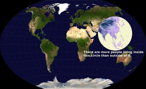
This is a fabulous map—but is the statement true?
I present this map without any context to my students and ask the question: is this statement true? How can we ascertain the truthfulness of this claim? What fact would we need to gather? This exercise sharpens their critical thinking skills and harnesses the assorted bits of regional information that they already have, and helps them evaluate the statement.
For some answers to these questions can be found here.
Tags: density, social media, East Asia, South Asia.
See on geographyeducation.org
Humanist geography, a movement within the field of human geography (itself a sub-field of geography) arose in the 1970s as a way to counter what humanists saw as a tendency to treat places as mere sites or locations. Instead, a humanist geographer would argue, the places we inhabit have as many personalities as those whose lives have intersected with them. And the stories we tell about places often say as much about who we are, as about where our feet are planted.
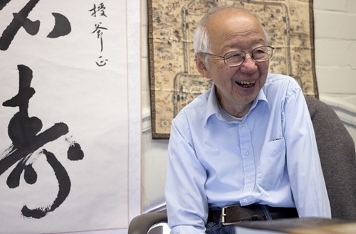
Anytime a geographer uses the phrase “sense of place, they owe an intellectual debt of gratitude to Yi-Fu Tuan. This article is an introduction to the man and his work that is accessible to all audiences.
Tags: place, unit 1 GeoPrinciples.
See on news.ls.wisc.edu
Scholars Online Videos feature top scholars answering a specific question in his or her field of expertise. These brief and informative videos are designed to supplement the Choices Program curricula.
In this Scholar’s Online video, Jennifer Fluri briefly answers this question: How has Afghanistan’s geography affected its history? This video nicely shows how contested international disputes have geographic dimensions to them. The very borders of Afghanistan were created out of geopolitical maneuverings.
Tags: Afghanistan, borders, political, culture, Central Asia,historical, colonialism.
See on www.choices.edu
“London-based design firm BERG created these two 3D maps of Manhattan, which look like a scene out of “Inception” (via Curbed NY).”
See on www.businessinsider.com
GeoGuessr is a geography game which takes you on a journey around the world and challenges your ability to recognize your surroundings.
When I was a child I used to wonder if woke up somewhere far from home, would I be able to know where I was just by looking at the places around me (I was a geo-geek from way back when). GeoGuessr is the closest thing to finding yourself lost in the world and needing to figure out where you are without being wisked away. GeoGuessr will display 5 locations in GoogleMaps “StreetView” and you have to guess where the images are located. You can pan and zoom in the StreetView to explore the landscape and find more context clues as to where that location is. It is a fantastic exploration exercise.
See on www.geoguessr.com
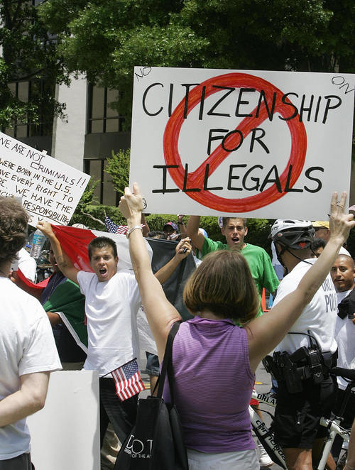
“In April, the Associated Press decided the word ‘illegal’ should only be used to describe actions, not people. It’s one of several major news outlets that have been reconsidering how to refer to people who are in this country illegally.”
Tags: migration, ethnicity, race, population, podcast.
See on www.npr.org
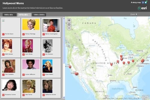
Famous TV Moms and where they lived. Happy Mother’s Day.
Today (May 10th) is Mother’s Day in Mexico and some other Latin American countries so what better time to share this map of TV Moms? Additionally, here are maps that display the various dates that different societies use to honor Mothers and Fathers.
Questions to Ponder: Many societies celebrate Mother’s Day around the vernal equinox and Father’s Day near the summer solstice. Is this a coincidence or are their some gendered messages in these cultural celebrations?
See on mediamaps.esri.com
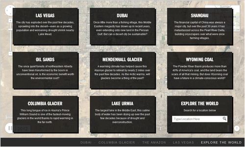
Exclusive timelapse: See climate change, deforestation and urban sprawl unfold as Earth evolves over 30 years.
This interactive feature includes various places that have experienced rapid environmental change in the last few decades. This is a simple way to show the power of remotely sensed data as well as massive environmental impact of rapid urbanization and globalization.
Tags: remote sensing, land use, environment, geospatial, environment modify, urban ecology.
See on world.time.com