Search

GEOGRAPHY EDUCATION

Supporting geography educators everywhere with current digital resources.

Author

sethdixon

I am a geography professor at Rhode Island College.

An Underground Pool Drying Up

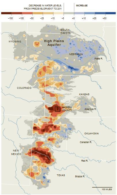
Portions of the High Plains Aquifer (Ogallala Aquifer) are rapidly being depleted by farmers who are pumping too much water to irrigate their crops, particularly in the southern half in Kansas, Oklahoma and Texas. Levels have declined up to 242 feet in some areas, from predevelopment — before substantial groundwater irrigation began — to 2011.

Seth Dixon‘s insight:

The article connected to this map from the New York Times can be found here.  “Two years of extreme drought, during which farmers relied almost completely on groundwater, have brought the seriousness of the problem home. In 2011 and 2012, the Kansas Geological Survey reports, the average water level in the state’s portion of the aquifer dropped 4.25 feet — nearly a third of the total decline since 1996.”


Tags: wateragriculture, environment, consumption, resources, environment depend.

See on www.nytimes.com

AP Human Geography: 2013 Free Response Questions

Seth Dixon‘s insight:

You can dowload the 2013 FRQs or any previously released FRQs on the AP Human Geography College Board website. 

See on media.collegeboard.com

bigbanner5.jpg

Tea for Two

“We came to Sri Lanka with every intention of filming a video about an organic, fair trade tea farmer. That is exactly what we were planning when we set foot on the small tea farm of Piyasena and his wife Ariyawatha. What we didnt expect was to be so taken with the relationship between the two of them. What started as a farm story quickly turned into a story about love and dedication amongst the Ceylon tea fields.”

Seth Dixon‘s insight:

The beginning of their love story is rooted in cultural traditions that many would find oppressive (arranged marriage), and yet their much about their sweet relationship that is near-universally admired. 

See on vimeo.com


Baby Name Regions?

“The Social Security Administration this week released its list of 2012’s most popular baby names by state, and maybe explained why there are so many Jacobs and Sophias in your kids’ schools. Do you see your kids’ names here?”

See on www.nickmom.com

Republicans and Millennials Are More Likely to Find Syria on a Map

45 percent think the U.S. should intervene, but only half can identify the country.

See on www.theatlantic.com

The Long Swath

“The Landsat’s natural-color imager scanned a swath of land 185-kilometers wide and 9,000 kilometers long (120 by 6,000 miles)—an unusual, unbroken distance considering 70 percent of Earth is covered with water. That flight path—depicted on the globe below—afforded us the chance to assemble 56 still images into a seamless, flyover view of what LDCM saw on April 19, 2013. Stretching from northern Russia to South Africa, the full mosaic from the Operational Land Imager can be viewed in this video.”

Seth Dixon‘s insight:

We typically see remotely sensed images as a single, still rectangular grid…this stunning video shows what the image collection process would look like from the perspective of the satellite.  This video is available to download in a variety of formats and resolutions.

Tags: remote sensing, geospatial, unit 1 GeoPrinciples.

See on www.youtube.com

LDCM-Long-Swath-overview

Prepping for the AP Human Geography exam

“Planning to take the Advanced Placement Human Geography exam from the College Board? Try these five suggestions for review.”

Seth Dixon‘s insight:

This is last minute, but every little bit can help.  Good luck tomorrow!

Tag: APHG.

See on www.examiner.com

Why isn’t New Orleans Mother’s Day parade shooting a ‘national tragedy’?

“American tragedies occur where middle America frequents every day: airplanes, business offices, marathons. Where there persists a tangible fear that this could happen to any of us. And rightfully so. Deaths and mayhem anywhere are tragic. That should always be the case. The story here is where American tragedies don’t occur. American tragedies don’t occur on the southside of Chicago or the New Orleans 9th Ward.”

Seth Dixon‘s insight:

This is a controversial Op-Ed article that discusses how the major axes of identity (race, class and gender) shape and intersect with the the national memory of violence and the media portrayal of violence.  According the David Dennis, “The media seems to forget about New Orleans and any place that the middle class can’t easily relate to.”  

Tags: race, class, gender, place.

See on www.guardian.co.uk

American English Dialects

There are 8 major English dialect areas in North America, presented on the map. These are shown in blue, each with its number, on the map and in the Dialect Description Chart, and are also outlined with blue lines on the map.  The many subdialects are shown in red on the map and in the chart, and are outlined with red lines on the map. All of these are listed in the margins of the map as well.

Seth Dixon‘s insight:

This map is incredibly busy, but the best elements of this interactive map are the links to YouTube videos of particular accents and pronunciation examples.  It’s not winning any cartographic prizes but the links make the map it worth perusing given its rich detail.  See also this article about the map from GeoCurrents.    

Tags: language, North America.

See on aschmann.net

Blog at WordPress.com.

Up ↑