Search

GEOGRAPHY EDUCATION

Supporting geography educators everywhere with current digital resources.

Category

Cities and Urban Land Use

America’s Real Homeless Hotspots

Via Scoop.itGeography Education

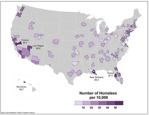
“An estimated 600,000 Americans are homeless, but the spread isn’t uniform. Some cities have been hit harder than others.”

When I teach cultural geography, I discuss the idea that some thing are “in place” and others are “out of place” based on the cultural norms that change from place to place.  Homelessness is almost always “out of place.”   What parts of the built environment in your city are purposefully uninviting to the homeless?  What is the connection between the city (and urbanization) and homelessness?  What could (or should) be done in major metropolitan areas with high rates of homelessness?  What is the spatial patterns evident in the geography of homelessness?  What accounts for these patterns?  What surprises are in the data from the article?

Via www.theatlanticcities.com

What March Madness Can Teach Us About the Economic Geography of Sports

Via Scoop.itGeography Education

The Atlantic Cities:  What exactly can account for the dominance of small and medium sized metros generally and college towns in particular in the economic…

While it is clear that superstar athletes in the professional ranks are concentrated in the largest cities, college athletics still let’s the ‘Davids’ compete with the ‘Goliaths.’  Interestingly, the largest cities don’t have the highest per capita concentration of athletes but many small college towns do.  Among the Top 25 cities with the highest concentration of athletes in the workforce (include scholarship athletes) we find South Bend, Indiana, home to Notre Dame; Auburn, Alabama, home to the university that bears its name; Ames, Iowa, home of Iowa State; Blacksburg, Virginia (Virginia Tech); Burlington, Vermont (University of Vermont); and Boulder, Colorado (University of Colorado).
Via www.theatlanticcities.com

Google Earth in China

Via Scoop.itGeography Education

This gallery of Google Earth Screen shots primarily from Yunnan Province in Southern China (bordering Vietnam and Burma) brings some keen spatial analysis to those unfamiliar with the region.  This is also a great example of using geospatial technologies to interpret the cultural landscape–the merger of ‘people and pixels’ as the textbook of the same name encourages with classrooms.  While the quality of this work is above what would be expected of students, a Google Earth project designed to get students to reassess the spatial dynamics within their neighborhood or home state could lead some fantastic projects.
Via www.facebook.com

Create a free website or blog at WordPress.com.

Up ↑