Search

GEOGRAPHY EDUCATION

Supporting geography educators everywhere with current digital resources.

Category

Scoop.it

Reality can be a Matter of Perspective

Human eyes could be easier to trick than you might think. A Japanese professor, Kokichi Sugihara, created sculptures that trick the mind to see the impossible. He was the winner of the Best Illusion of the Year Contest in 2010 and 2nd place in 2016.”


Tags: spatial, perspective. 

Source: www.youtube.com

Growth of underwater cables that power the web

“The map above, created with data from Telegeography, shows how those cables have developed since 1990. Most existing cables were constructed during a period of rapid growth in the mid-2000’s. This was followed by a gap of several years during which companies steadily exhausted the available capacity. Over the last few years, explosive new demand, driven by streaming video, has once again jumpstarted the the construction of new cables.”

Source: qz.com

Twenty years ago, people were still connecting to the internet with a dial-up connection through their modem (if you don’t know what that sounds like, this was once the sound of interconnectivity).  People focus on cell phones, tablets, and cool gadgets when discussing the digital transformation of globalization, but it all rests on the infrastructure of the global connectivity that is mapped out here.  Even still, global trade rests on the back of container ships moving manufactured goods from far-flung factories to major markets.


Tags: technology, globalization, diffusion, industry, economic.

The Whale’s Tail

“The Ballena Marine National Park is located in Puntarenas, at the South Pacific coast of Costa Rica.” 

Source: www.ballenainfocenter.com

This National Park in Costa Rica is a delightful example of many things geographic.  Not only is the local biogeography make this a place famous for whales (ballena in Spanish), but the physical geography also resembles a whale’s tail.  This feature is called a tombolo, where a spit connects an island or rock cluster to the mainland. Additionally, there is also a great community of citizen cartographers mapping out this park and the surrounding communities. 


Tagsbiogeography, environment, geomorphology, physicalwater, landforms.

U.S. Students Are Really Bad at Geography

Your kid has no idea where Saudi Arabia – or maybe even South Carolina – is. Here’s why.

Source: www.usnews.com

The U.S. government report on 8th grade geography is not a ‘pick-me-up’ but a sobering reminder of the task that lays before us.  This article quotes a few alliance coordinators on the current situation and how to change it. 


TagseducationK12geography education.

Factory farming practices are under scrutiny again in N.C. after disastrous hurricane floods

As fecal waste and bacteria flow from hog lagoons into the water supply, North Carolina is revisiting a contentious battle between the pork industry, health experts and environmentalists.


In regions where hog farm density is high, there is an overall poor sanitary quality of surface waters. The presence of mass-scale swine and poultry lots and processing plants in a sandy floodplain – a region once dotted by small tobacco farms – has long posed a difficult dilemma for a state where swine and poultry represent billions of dollars a year for the economy. [Past] hurricane’s environmental impact in North Carolina were so severe in part because of the large number of hog lagoon breaches. Following Hurricane Matthew, the department has counted 10 to 12 lagoons that were inundated, with floodwaters topping the berms and spreading diluted waste.


Tags: food, agriculture, agribusiness, unit 5 agriculture, agricultural environment, environment, environment modify, pollution

Source: www.washingtonpost.com

Four maps that explain the chaos of the Middle East

“Without trying to defend or absolve U.S. policy, then, it is worth stepping back to ask what shared historical experiences might have left these four countries — Iraq, Syria, Libya and Yemen — particularly at risk of violent collapse. The following maps help highlight how, at various points over the past century, historical circumstances conspired, in an often self-reinforcing way, to bolster the stability of some states in the region while undermining that of others.”

Source: www.washingtonpost.com

These maps are not cartographically inspiring, but the it’s the historical and political insight that makes them valuable. The goal of this set of maps is to find some underlying causal reasons for political stability(or more importantly instability) in the Middle East. These four maps focus on these key issues:

1. Century-old states are more stable today

2. Colonial rule led to fragile states

3. Instability and regime change

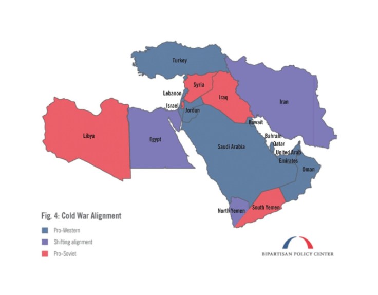
4. The shadow of the Cold War


Tags: MiddleEast, war, conflict, political, geopoliticshistorical.

What This 2012 Map Tells Us About America, and the Election

History, race, religion, identity, geography: The 2012 election county-level map has many stories to tell, including about the 2016 race.

Source: www.nytimes.com

The coverage of this election feels less objective than in past years (maybe that’s just my perception, but that is why I’ve shared less electoral resources than in past years).  This article show’s good map analysis and electoral patterns without much of any ideological or partisan analysis of the political platforms.  


Tags: electoral, political, mapping.

The other Asian tiger

“Vietnam’s success merits a closer look.”


Which Asian country has roared ahead over the past quarter-century, with millions of its people escaping poverty? And which Asian economy, still mainly rural, will be the continent’s next dynamo? Most would probably respond “China” to the first question and “India” to the second. But these answers would overlook a country that, in any other part of the world, would stand out for its past success and future promise.

Vietnam, with a population of more than 90m, has notched up the world’s second-fastest growth rate per person since 1990, behind only China. If it can maintain a 7% pace over the next decade, it will follow the same trajectory as erstwhile Asian tigers such as South Korea and Taiwan. Quite an achievement for a country that in the 1980s was emerging from decades of war and was as poor as Ethiopia.


Tags: Vietnam, globalizationdevelopment, economic, SouthEastAsia.

Source: www.economist.com

Portraits Of NYC Immigrants Reveal Cultural Backgrounds

Here are just a handful of the 12 million men, women, and children who arrived at Ellis Island, New York, between 1892 and 1954 to start a new life in the USA, often dressed in their finest clothes. The portraits show immigrants wearing the national dress of their country of origin, including military uniforms from Albania, bonnets from the Netherlands, and clothing of Sámi people from the Arctic regions.

The photographs were taken between 1906 and 1914 by amateur photographer Augustus Francis Sherman, the chief registry clerk at Ellis Island, then the country’s busiest immigration station. In 1907 some of the photos were published by National Geographic.

Source: www.buzzfeed.com

These images show some of the diverse cultural backgrounds of turn-of-the-century American immigrants.  The formal clothing that represents the folk cultures that they came from hint at the massive cultural shift that these immigrants must have experienced upon arriving to the United States.  These photos of migrants wearing clothing representing their Old World lives right as they are about to culturally assimilate (or acculturate) into the New World are pictures I find quite poignant and personal.    


Tagsculturemigrationhistorical, folk culturesethnicity, unit 3 culture.

Blog at WordPress.com.

Up ↑