Search

GEOGRAPHY EDUCATION

Supporting geography educators everywhere with current digital resources.

Category

Uncategorized

Business Languages In Africa


“The Main Languages of Business in Africa.”

Seth Dixon‘s insight:

While this is not a perfect map, if is still a powerful one to convey several points.  One, the impact of colonialism is still felt in the the cultural, economic and political institutions of Africa.  Two, given that most of African countries have many indigenous languages spoken by the population, the old colonial language remains as a de facto Lingua Franca in most places, especially among the elite.  Take note of the OTHER category. Why is it other? What can we infer from this ‘othering’ of the only language native to Africa on the map?

Tags: language, Africa, colonialism.

See on www.africacncl.org

5-African-Business-Languages

The Dozen Regional Powerhouses Driving the U.S. Economy

The Boston-Washington corridor, home to 18 percent of Americans, produces more economic activity than Germany.

See on www.theatlanticcities.com

Great Salt Lake: Landsat Science

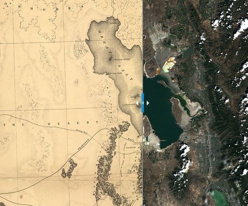
With imagination one can explore and understand how very different life was for people in the United States before the Golden Spike was hammered into the ground in Utah in 1869. That was a much-hailed event that knitted the country together by linking two railroad lines from the eastern and western ends of the continent. Just ten years earlier, when the map at left was made, life was more centered on local transactions. It was hard for families with children to visit friends because travel in this part of the country was slow and arduous, over bumpy dirt roads by horse and wagon. A life involving daily travel for several miles from home each day to work was not feasible. Yet change was in the air even then.

Engineers had put together the recently-invented steam engine with the practicality of a road made of rails and cross-ties, and businessmen and politicians were envisioning a national transportation network – a railroad system. What a difference that could make in the life of this still-young nation! The federal government began sending dozens of mapmakers across the country to identify and draw the best routes for a national railroad in an initiative called “the Great Reconnaissance.”

The national railroad system brought a revolution in commerce and mind-set to the United States in the 19th century. Landsat technology has fomented a revolution of its own, making hundreds of maps of landscapes around the globe daily and becoming an integral part of our national infrastructure just as the railway system and automobile Interstate Highway Systems did in previous eras. With Landsat we have our own 21st century Great Reconnaissance.

See on landsat.gsfc.nasa.gov

Teaching Kids about Global Poverty

Living on One Dollar is a full-length documentary made by four college students who traveled to rural Guatemala to live on just a dollar a day. Upon their return, they created Living On One, a nonprofit to raise awareness and inspire action around global issues like hunger and poverty — and started by publishing the Change Series of video shorts. I found it so compelling I’ve dedicated this whole film fest to it. Each episode not only succinctly frames an issue faced by people in the developing world and makes it personal, but also offers resource links to learn more — and even better — to do something about it.”

Seth Dixon‘s insight:

This set of eight videos that are all roughly 5 minutes bring up a variety of topics on on global poverty, development and economic issues that bring in a human element so that these topics are tied to real people and real decisions.

See on www.edutopia.org

Demographic Atlas

This atlas shows how the population is changing – growing in some parts of the country, while shrinking in others. The maps show the entire United States by county, using data from the U.S. Census Bureau’s 2010 Census and Esri. How do things look in your neighborhood?

See on atlas.esri.com

Global Oil Reserves

Who has the oil? pic.twitter.com/7Njc7OD8rw

Seth Dixon‘s insight:

Natural resources are not evenly distributed…this distribution pattern impacts global economics, industrialization, development and politics tremendously.  

Tags: industry, economic, energy, resources.

See on www.energybulletin.net

World’s Muslim population more widespread than you might think


There are about 1.6 billion Muslims, or 23% of the world’s population, making Islam the second-largest religion.

Seth Dixon‘s insight:

Did you think that most of the world’s Muslim population lived in the Middle East and North Africa?  If so you are not alone, but the Middle East and North Africa account for only 19.8% of the global Muslim population.  In fact there are more Muslims in India and Pakistan than the Middle East and North Africa.   

Tags: Islam, perspective, religion, culture, Middle East.

See on www.pewresearch.org

MuslimPopulationDistribution

3 Cities With Freeways Going Nowhere

Once thought to be symbols of prosperity, innercity highways are now just eyesores — and sources of civic dysfunction — to some new urbanists.

Seth Dixon‘s insight:

This TED Talk also explores what cities should be with old freeways, suggesting that they should be dismantled and the spaces revitalized (and yes, my inner-Californian linguistic roots demands that I call them freeways).


Tags: transportation, urban, planning.

See on www.npr.org

19th Century Ship Routes

Ben Schmidt, assistant professor of history at Northeastern University, has visualized the routes of 19th Century ships using publicly available data set from NOAA (National Oceanic and Atmospheric Administration). The resulting image is a hauntingly beautiful image that outlines the continents and highlights the trade winds. It shows major ports, and even makes a strong visual case for the need for the Panama and Suez Canals.”

See on unifiedpoptheory.com

Blog at WordPress.com.

Up ↑