How globalization has changed the nature of urban development.
See on www.theatlanticcities.com
“A fisherman’s cottage is described by real estate agents as a ‘property not to be missed’ but it is also just yards away from two nuclear power stations.”
A photograph (or landscape, map, etc.) is not an innocent reflection of reality. They can be carefully crafted to tell a story which might reflect the bigger picture and your ideological framework–but it just as easily might obscure some important contexts and truths. I use these images at the beginning of the semester to discuss the bias inherent in our own perspectives as I try to infuse my classroom with a variety of lenses with which to view different regions (images found here).
Tags: images, landscape, perspective, regions.
See on www.telegraph.co.uk
Explore a global timelapse of our planet, constructed from Landsat satellite imagery. With water diverted to irrigation, the inland Aral Sea has shrunk drama…
The collapse of the Aral Sea ecosystem is (arguably) the worst man-made environmental disaster of the 20th century and 21st century has seen the desertification continue. Soviet mismanagement, water-intensive cotton production and population growth have all contributed the overtaxing of water resources in the Aral Sea basin, which has resulted in the shrinking of the Aral Sea–it has lost more of the sea to an expanding desert than the territories of the Netherlands, Belgium and Luxembourg combined. The health problems arising from this issues are large for the entire Aral Sea basin, which encompasses 5 Central Asian countries and it has profoundly changed (for the worse) the local climates. Compare the differences with some historical images of the Aral Sea on Google Earth or on ArcGIS Online (also see this article from GeoCurrents).
Tags: environment, Central Asia, environment modify.
See on www.youtube.com
Thirty years ago, the states with the deepest poverty were all clustered in dixie. But the rest of the country has been playing catchup.
So how did poverty stop being a Southern specialty? You’ve had, deindustrialization in the Midwest and Northeast. And you’ve had fast growing Hispanic populations, which tend to be poorer, in California, Nevada, Arizona, and Colorado (as well as North Carolina and Georgia, which could explain their presence on the list above). Meanwhile, the Southeast has made some economic progress by attracting foreign manufacturing, among other efforts.
See on www.theatlantic.com
“In Raleigh, N.C., there’s a house… or what looks like a house. What’s hidden inside is more important than most people realize. Read the story: http://wunc.org/post/video-whats-inside-house-wade-avenue ”
What looks like a wonderful little “Scooby-Doo” mystery turns out to be a great lesson on city planning, land use and utilities (I don’t want to ruin the surprise that comes at the 2 minute mark, but don’t worry, it’s worth it). If you are teaching a course trying to help students to think about the inner-workings of a city this article would be a very attention grabbing way to make a good point. What ‘secrets’ are hidden in plain sight in your local neighborhood?
See on www.youtube.com
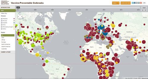
The Global Health Program at the Council on Foreign Relations has been tracking news reports since 2008 to produce an interactive map that plots global outbreaks of diseases that are easily prevented by inexpensive and effective vaccines.
See on www.cfr.org

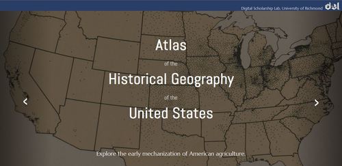
“The Digital Scholarship Lab at the University of Richmond has created an enhanced version of the Atlas of the Historical Geography of the United States, which was published in 1932. The atlas, which took dozens of researchers to assemble, used maps to illustrate a variety of political, demographic and economic concepts.”
I’m sure many of you have already seen it but this is a gem. This is something that you must explore on your own, but I will say that there should be something for everyone in this digital treasure trove. Read a New York Times review on the digital atlas here.
See on dsl.richmond.edu

Colliding continents and cracks in the Earth’s crust make for some remarkable scenery in western China.
Just south of the Tien Shan mountains, in northwestern Xinjiang province, a remarkable series of ridges dominate the landscape. The highest hills rise up to 1,200 meters (3,900 feet) above the adjacent basins, and they are decorated with distinctive red, green, and cream-colored sedimentary rock layers. The colors reflect rocks that formed at different times and in different environments. When land masses collide, the pressure can create what geologists call “fold and thrust belts.” Slabs of sedimentary rock that were laid down horizontally can be squeezed into wavy anticlines and synclines.
The ridge is noticeably offset by a strike-slip or “tear” fault in the image showing the Piqiang Fault, a northwest trending strike-slip fault that runs roughly perpendicular to the thrust faults for more than 70 kilometers (40 miles). The colored sedimentary rock layers are offset by about 3 kilometers (2 miles) in this area.
See on earthobservatory.nasa.gov
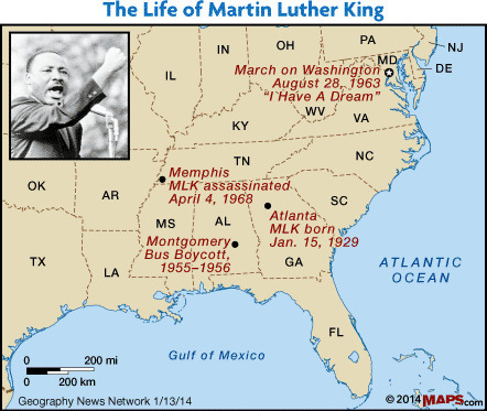
“Dr. Martin Luther King Jr. once stated,”A man who won’t die for something is not fit to live.” Arrested over twenty times, stabbed in the chest, his house firebombed and, ultimately shot and killed, King embodied the idea that equality and the African American Civil Rights Movement were worth dying for.He was a husband and father to four children as persecution and death threats filled his days, yet his example was one of nonviolent, civil disobedience.Had he not been assassinated, King would have celebrated his 85th birthday on January 15th.”
Dr. Martin Luther King fought racial segregation (which, if you think about it, is a geographic system of oppression that uses space and place to control populations). Dr. King has been described as a critical geographer for some of his insights. In 1967, MLK stated, “The expansion of suburbia and migration from the South has worsened big-city segregation. The suburbs are a white noose around the black necks of cities… suburbs expand with little regard for what happens to the rest of America.” If you are a Maps 101 subscriber, please read the rest of this article that I co-authored with Julie Dixon. You can also sign up for a free trial subscription.
See on www.maps101.com