Search

GEOGRAPHY EDUCATION

Supporting geography educators everywhere with current digital resources.

Category

Uncategorized

‘Absolute Bedlam’ In The Philippines After Typhoon Haiyan

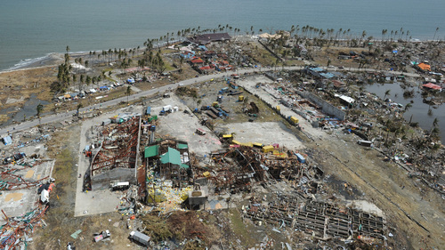
The news from the Philippines, where it’s feared that last week’s powerful Typhoon Haiyan killed more than 10,000 people, isn’t getting better as hundreds of thousands of people struggle to survive and authorities struggle to get help to them.

“Its absolute bedlam right now,” says Richard Gordon, head of the Philippine Red Cross.  “There’s an awful lot of casualties, a lot of people dead all over the place, a lot of destruction.”

According to the BBC, a huge international relief effort is underway, but rescue workers have struggled to reach some towns and villages cut off since the storm.

Tags: physical, environment, water, disasters, Philippines.

See on www.npr.org

National cemeteries create a ‘sacred grove’ of equality

In the end, rank falls away

Seth Dixon‘s insight:

This Veteran’s day many will go to cemeteries to remember fallen soldiers.  These are secular sites, but still sacred space to many.  The sanctity of these places are intentional and considerable planning goes into the spatial layout and design of the cemeteries.  Enjoy the day off for Veteran’s Day, but don’t forget to remember.

See on www.startribune.com

Why is Geography Education so Important?

Seth Dixon‘s insight:

This commencement speech from the President of the American Geographical Society highlights the importance of geographic thought and geo-literacy for college graduates.  I share this because (to quote Summer Howarth), “geo-literacy isn’t really optional.” 

See on www.amergeog.org

The 11 American nations, in one map

Red states and blue states? Flyover country and the coasts? How simplistic. Colin Woodard, a reporter at the Portland Press Herald and author of several books, says North America can be broken neatly into 11 separate nation-states, where dominant cultures explain our voting behaviors and attitudes toward everything from social issues to the role of government.

“The borders of my eleven American nations are reflected in many different types of maps — including maps showing the distribution of linguistic dialects, the spread of cultural artifacts, the prevalence of different religious denominations, and the county-by-county breakdown of voting in virtually every hotly contested presidential race in our history,” Woodard writes in the Fall 2013 issue of Tufts University’s alumni magazine. “Our continent’s famed mobility has been reinforcing, not dissolving, regional differences, as people increasingly sort themselves into like-minded communities.”

Take a look at his map.

See on www.washingtonpost.com

Geography Poster

See on rigea.files.wordpress.com

Guide to Earth Explorer for Landsat 8

The Landsat Data Continuity Mission is now Landsat 8, and that means images are now public (woohoo!). NASA handed control of the satellite to the USGS earlier this year (May 30, 2013), and calibrated imagery is available through the Earth Explorer. Unfortunately, the Earth Explorer interface is a bit of a pain, so I’ve put together a guide to make it easier.

Seth Dixon‘s insight:

If you have been afraid to download remotely sensed images, this is a very-user friendly, step-by-step guide on how to download Landsat 8 data (and many other geospatial datasets)  using Earth Explorer from USGS.  

Tagsremote sensing, geospatial.

See on earthobservatory.nasa.gov

Create Your Own Map

MyMap

Create a color-coded Visited States Map, showing off your road travel in the United States and Canada.

Seth Dixon‘s insight:

This is map represents where I have been (green) and where I have lived (orange).  Super easy, anyone can use this site to create a small PNG file that maps out North America (maximum of 5 colors, including white).  For more on how to create your own, read here.

See on www.defocus.net

Modern Slavery

“I recently saw this map in a Washington Post article about modern day slavery and was immediately was struck by the spatial extent and amount of slaves in today’s global economy.  As stated in that article, “This is not some softened, by-modern-standards definition of slavery. These 30 million people are living as forced laborers, forced prostitutes, child soldiers, child brides in forced marriages and, in all ways that matter, as pieces of property, chattel in the servitude of absolute ownership.”  This map shows some important spatial patterns that seem to correlate to economic and cultural factors.”

Seth Dixon‘s insight:

This got me thinking to the geographies of supply chains.  The growing spread of the informal economy (a.k.a.-illicit trade, black market, etc.) has created opportunities for exploitation.  Many argue that free trade was created this power differential between the laborers who create these mass-manufactured products and the global consumers.  These critics argue that fair-trade, not free trade, with lead to sustainable economic growth and minimize social injustice. 

Questions to Ponder:  What economic and cultural forces are needed for slavery to thrive?  What realistically could be done to lessen the amount of slavery in the world today?  How are your spending habits part of the system?

This TED video (archived on scoop.it here) is a chilling glimpse into the worst and darkest side of the global labor system. 

Tags: labor, economic, class, poverty.

Geography of Quinoa

“The popularity of Quinoa has grown exponentially among the health-conscious food consumers in the developed economies of the world.  Quinoa (pronounced KEEN-wah) is rich in protein and is a better grain for those seeking to lose weight.  Quinoa has historically be rather limited but this diffusion is restructuring the geographic patterns of many places.” 

gitn_1195_NGS_Quinoa-2

Seth Dixon‘s insight:

This map from a Geography in the News article shows that Quinoa has historically been grown almost exclusively in the highlands of the Andes Mountains.  This was a localized food source for generations but this new global demand has increased the economic possibilities for Quinoa growers.  At the same time, local consumers that have traditionally depended on cheap Quinoa to supplement their diet are now effectively priced out, as stated in this Al-Jazeera article

Questions to Ponder: What modern and traditional agricultural patterns can we see in the production of Quinoa?  How have global and local forces reshaped the system?

Tags: agriculture, food production, foodglobalization, South America, folk cultures, culture, Bolivia.

See on geographyeducation.org

Blog at WordPress.com.

Up ↑