Search

GEOGRAPHY EDUCATION

Supporting geography educators everywhere with current digital resources.

Category

Uncategorized

Coastal Hazard Threat Map

This interactive map of coastal Massachusetts and Rhode Island shows some basic flooding data including: 1) where are the flood warnings (essential the entire coastline), 2) how high the storm surge is, and 3) how high the waves are.

Tags: Rhode Island, water, disasters, geospatial.

See on www.erh.noaa.gov

Manifest Destiny in 141 Maps

This data visualization project is a great way to demonstrate the geographic expansion of the United States.  This is much more interactive than the typical time lapse video since you can scroll through the maps and explore each map through the interactive features. 

Tags: historical, USA, visualization, mapping.

See on michaelporath.com

Monitoring the Storm Surge

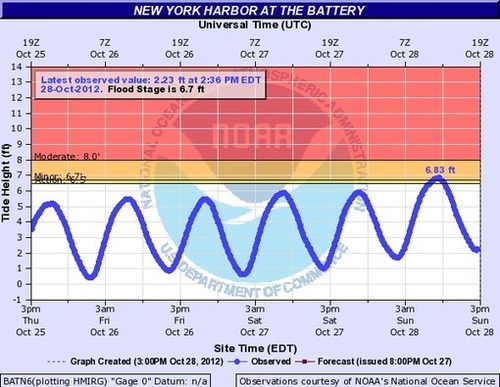
National Weather Service Advanced Hydrologic Prediction Service…

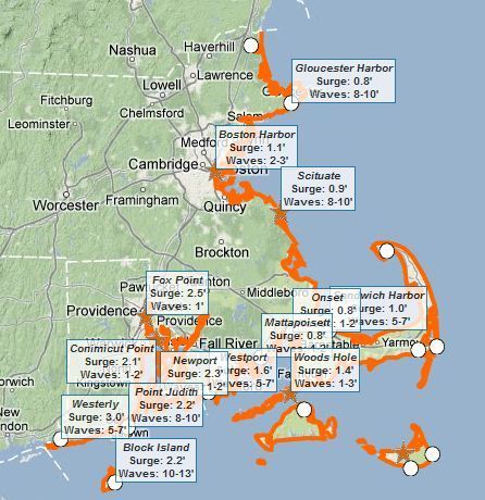
When the Pawtuxet River flooded in Rhode Island I was watching this site to get a sense of how bad the flooding was and to put it in historic context (the National Weather Service has links to live data at many locations) .  This station in NYC at the Battery is important to keep an eye on with Hurricane Sandy because if the strom surge is over 10 feet, the subway system could flood and the issues confronting New York would be devastating.  As meterologist Andy Lesage noted, “During Irene it got to 9.5ft, 8-12 inches shy of flooding the subway system so if the Battery gets to something like 10.25+ ft, it will indicate massive damage to the cities’ infrastructure.”

Tags: disasters,water, physical, NYC, transportation, weather and climate.

See on water.weather.gov

Iconic Skylines

These skylines are not to scale, but are composite skylines to groups together the iconic representations of the particular cities into one.


Tags: urban, Paris, London, place, tourism.

See on cognacandcoffee.tumblr.com

Make your own Mega Map

I love National Geographic’s MapMaker Kit as a great way to have students produce their own oversized Mega Maps  (8 rows of 17 columns), especially if you only have access to a printer that p…

Here are 6 lessons and activities designed around National Geographic’s Mega Maps and Tabletop Maps that can be printed with ordinary 8.5 x11 sheets of paper.  This is a perfect way to celebrate and get ready for Geography Awareness Week (Nov . 11-17). 

Tags: mapping, K12, National Geographic, Geography Education

See on rigea.org

Trekking the Grand Canyon for Google Maps

The term “street view” in Google Maps is continually getting stretched as the world’s oceans, canyons, mountains and even cemeteries are being added to this ever-expanding database. 

Tags: Google, mapping, cartography, geospatial, cemetery

See on googleblog.blogspot.fr

In A Tanzanian Village, Elephant Poachers Thrive

In an impoverished country, elephant poaching is a quick way to make big money. A pair of poachers explain how they track and kill elephants in one of Africa’s top game reserves.


The illegal sale of ivory in places such as Asia drive the elephant poachers to prey on Elephants in protected game reserves and national parks.  The Selous Game Reserve is larger than Switzerland and yet they only have 10 rangers to protect and patrol the wildlife.


Tags: biogeography, poverty, globalization, Africa, consumption, resources, ecology, podcast.

See on www.npr.org

The Geography of Swing States

Right now, the conventional wisdom says that there are just nine states that might go either way on Nov. 6th.

Not all votes are created equally; votes in these 9 key states have a greater likelihood of impacting the actual outcome of the Presidential election.  If we assume that the other states vote as anticipated, and that each candidate has an equal opportunity in the remaining 9 states (yes, these are a major assumptions, but work with me), than President Obama has a 84% likelihood of winning in the 512 possible permuations.  Geographer Andy Baker has created a video that provides a solid non-partisan analysis of the political geography of these states (and other) states.

Tags: political, unit 4 political.

See on www.theatlanticwire.com

Hurricane Sandy may be unprecedented in East Coast storm history

WEATHER GANG | With computer models locked in on the eventuality of a punishing blow for East Coast from Hurricane Sandy, analyses suggest this storm may be unlike anything the region has ever experienced.

This weekend’s storm for the East coast is especially interesting.  I won’t pretend to be a meteorologist, so I’ll quote one: “The upper-air steering pattern that is part of the puzzle is not all that unheard of. It happens when the atmosphere gets blocked over the Atlantic and the flow over the U.S. doubles back on itself. Sometimes big winter storms are involved.  The freak part is that a hurricane happens to be in the right place in the world to get sucked into this doubled-back channel of air and pulled inland from the coast.”  Stay safe everyone on the east coast.   

Tagsweather and climate, physical, disasters

See on www.washingtonpost.com

Create a free website or blog at WordPress.com.

Up ↑