Search

GEOGRAPHY EDUCATION

Supporting geography educators everywhere with current digital resources.

Category

Uncategorized

For Florists, Roses A Nerve-Racking Business Around Valentines Day

Valentines Day is this one day when one product — a red rose — is worth two or three times more than it is at any other time of the year. If a florist catches that window, he’s golden. But the process of getting the roses to is fraught with risk, middlemen, crazy expense and bad weather.

Source: www.npr.org

This NPR podcast looks at the economic fluctuations of the flower market based on the cultural festival that is Valentines Day, and this Guardian article examines the economic development issues in the commodity chain for cut flowers (focused on Colombia). 

Solar Dynamics Observatory

“”February 11, 2015 marks five years in space for NASA’s Solar Dynamics Observatory, which provides incredibly detailed images of the whole sun 24 hours a day. Capturing an image more than once per second, SDO has provided an unprecedentedly clear picture of how massive explosions on the sun grow and erupt ever since its launch on Feb. 11, 2010. The imagery is also captivating, allowing one to watch the constant ballet of solar material through the sun’s atmosphere, the corona.”

Source: www.youtube.com

As Phil Plait states in this Slate article, “There’s so much to take in there. Rolling sunspots, eruptive prominences, collapsing filaments, solar flares, the Transit of Venus (twice!)…SDO is far more than I imagined, and has revealed our active and complex star far better than anything before it.”

Tags: Sunspace, video.

32 Mispronounced Places

“There’s nothing more irritating to a pedant’s ear and nothing more flabbergasting than realizing you’ve been pronouncing the name of so many places wrong, your entire life! Despite the judgment we exhibit toward people who err in enunciating, we all mispronounce a word from time to time, despite our best efforts. Well, now it’s time we can really stop mispronouncing the following places.”

Source: www.thrillophilia.com

I’ve only been mispronouncing 8 of them, but many of these toponyms (place names) are chronically mispronounced.  Some of these have curious local of pronouncing the name, while others show that translating one language into another can be quite difficult since many sounds don’t naturally flow off the tongue of non-native speakers.   

Tagslanguage, toponyms, culture, tourism.

Mapping the World’s Problems

Google Earth Engine works with scientists by using satellite imagery to provide data visualizations for environmental and health issues.

Source: www.nytimes.com

Geography isn’t just a body of knowledge that someone understands; it’s about decision-making to evaluate the impacts and taking actions to make the world a better place.  This NY Times article is a great example of how geospatial tools can monitor human/environmental issues to be able to effectuate change.  

Tags: google, mapping, geospatial.

London’s second languages mapped by tube stop

“Walk along the streets of London and it’s not uncommon to hear a variety of langauges jostling for space in your eardrums. Step inside a tube carriage on the underground and the story is no different.

Oliver O’Brien, researcher in geovisualisation and web mapping at University College London’s department of geography, has created a map showing what the most common second language (after English) is at certain tube stops across the capital.

Using a map of tube journeys and busy stations that he had previously created, O’Brien used 2011 Census data to add the second most commonly spoken language that people who live nearby speak.”

Source: www.theguardian.com

This map is an excellent way to introduce the concept of ethnic neighborhoods and show how they spatially form and what ties them together. 

Tags: London, urbantransportation, ethnicitylanguage, culture.

38 maps that explain Europe

Europe, as both a place and a concept, has changed dramatically in its centuries of history.

Tags: Europe, map.

Source: www.vox.com

‘I was 14 when I was sold’

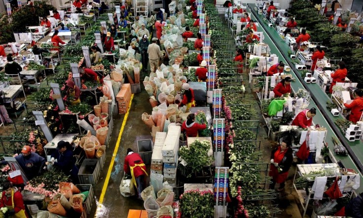
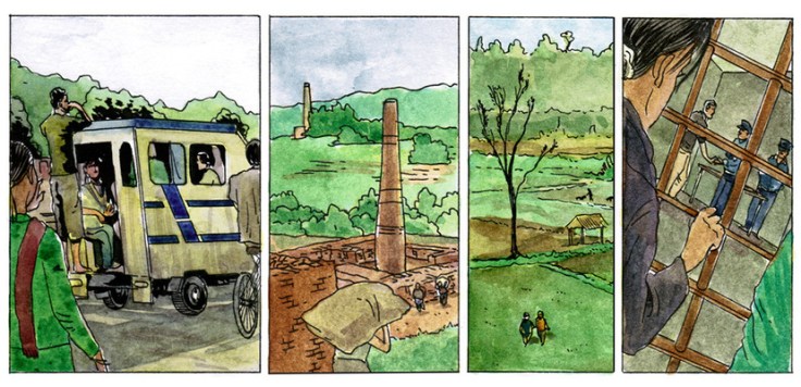
Laxmi’s story of being kidnapped and trafficked in Nepal is not an isolated case but, as this graphical account shows, things are not always what they seem.

Source: www.bbc.co.uk

Teaching about human trafficking and child slavery can be very disconcerting and uncomfortable.  How much of the details regarding these horrific situations is age-appropriate and suitable for the classroom?  The BBC is reporting on events with sensitive stories to both give a human face to the story, while protecting the identity of under-aged victims (to read about the production of this comic, read Drawing the News.)  I encourage you to use your own discretion, but I find this comicbook format an accessible, informative and tasteful way to teach about human trafficking in South Asia to minors.  It is a powerful way to teach about some hard (but important) aspects of globalization and economics. 

As geographer Shaunna Barnhart says concerning this comic, “It moves from trafficking to child labor to pressures for migration for wage labor and the resulting injustices that occur. There’s differential access to education, gender inequality, land, jobs, and monetary resources that leads to inter- and intra-country trafficking of the vulnerable. In the search for improved quality of life, individuals become part of a global flow of indentured servitude which serves to exploit their vulnerabilities and exacerbate inequalities and injustice. Nepali children ‘paid’ in food and cell phones that play Hindi music in ‘exchange’ for work in textile factories – cell phones that are themselves a nexus of global resource chains and textiles which in turn enter a global market – colliding at the site of child labor which remains largely hidden and ignored by those in the Global North who may benefit from such labor.”

Tags: Nepal, labor, industry, economic, poverty, globalization, India.

Ecological Corridors

“Various ecological, political and economic perspectives on habitat fragmentation from the West Wing: season 1, episode 5.”

Source: www.youtube.com

Our modern society depends on greater connectivity between places.  Regionalized economies, politics and transportation networks are increasingly integrated with far-flung places now more than ever before.  Our biosphere and natural environments are exceptions to this pattern.  Wilderness areas are ‘islands’ in an ocean of human controlled environments.   We create transportation linkages that unite people economies and cities, but separate herds from their extended habitat. 

We’ve all seen road kill on major highways.  Species like deer, elk, and grizzly bears and other large-bodied animals need a wide range for numerous ecological reasons.  These bridges are an attempt to ameliorate some of the problems that our roads pose for the non-human species that still call Earth home.  From a purely economic standpoint, many argue that these bridges save society money given the accidents and property damage that can be avoided. 

Just for fun: This is a hilarious/painful video of a woman who clearly doesn’t understand these principles.

Tags: biogeography, transportation, environment, land use, sustainability, environment adapt.

History of Lynchings in the South Documents Nearly 4,000 Names

After compiling an inventory of 3,959 lynching victims in 12 Southern states from 1877 to 1950, the Equal Justice Initiative wants to erect markers and memorials on certain sites.

Tags: raceconflict, racism, historical, the Southlandscape.

Source: www.nytimes.com

Create a free website or blog at WordPress.com.

Up ↑