Search

GEOGRAPHY EDUCATION

Supporting geography educators everywhere with current digital resources.

Kazakhstan renames capital of Astana to Nur-Sultan

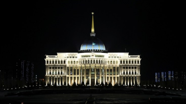
"Astana has been renamed as Nur-Sultan, as a tribute to former leader Nursultan Nazarbayev, who recently resigned. Astana replaced Almaty as the capital in 1997 and boomed from a minor provincial steppe town into a futuristic city. The name Astana literally means ‘capital’ in Kazakh and there has long been speculation it could, at some point, be renamed after the leader who shaped it."

Source: www.aljazeera.com

St. Petersburg was the classic example of a forward capital that was renamed after the visionary leader responsible for that change.  The world now has another example of this phenomenon. 


GeoEd Tags: political, Central Asia, Kazakhstan.

Scoop.it Tags: political, Central Asia, Kazakhstan.

Healthy Nation Rankings: These Are the Healthiest Countries

"Maybe it’s something in the gazpacho or paella, as Spain just surpassed Italy to become the world’s healthiest country."

Source: www.bloomberg.com

This data offers excellent insight into regional developmental patterns around the world–it is very much worth exploring.  However I’m sharing this also for it’s mapping project potential; the data behind this map is available in the article and students can make their own maps with it.  


GeoEd Tags: mortality, medical, development, food, mapping.

Scoop.it Tagsmortality, medicaldevelopmentfood, mapping.


Trump: Time to recognise Golan Heights as Israeli territory

“Israel has occupied the strategic plateau since capturing it from Syria in the 1967 Middle East war. There are more than 30 Jewish settlements on the heights, with an estimated 20,000 settlers.

There are some 20,000 Syrians in the area, most of them members of the Druze sect.”

Source: www.bbc.com

I had my class all ready to go, and then this happened. The Golan Heights is a small chunk of land, 3 times larger than Rhode Island, is far more important geopolitically than its size would indicate. This land is Israeli controlled, but internationally still considered a part of Syria, much like Russia controls Crimea, but it is still internationally recognized as a part of Ukraine.   Not surprisingly, Syria has condemned these statements from the President of the United States as have many members of the international community

GeoEd Tags: Syria, Israel, political, MiddleEast, geopolitics.

Scoop.it TagsSyria, Israel, political, Middle East, geopolitics.

GFPLAIN250m, a global high-resolution dataset of Earth’s floodplains

Identifying floodplain boundaries is of paramount importance for earth, environmental and socioeconomic studies addressing riverine risk and resource management. However, to date, a global floodplain delineation using a homogeneous procedure has not been constructed. In this paper, we present the first, comprehensive, high-resolution, gridded dataset of Earth’s floodplains at 250-m resolution (GFPLAIN250m).

Source: www.nature.com

Satellites see the world as a bunch of pixels.  In this recent article in the journal Nature, the authors used a global set of satellite images to create the first global layer of floodplains.  This data is now publicly accessible as a free download (one you can put into ArcGIS after the files are extracted and zipped).     


GeoEd Tags: mapping, ESRI, GIS, remote sensing.

Scoop.it Tags: mapping, ESRI, GIS, remote sensing.

Why China Ended its One-Child Policy

"China has huge ambitions for the 21st century. But it’s demographic problems will be a significant challenge on the way there."

Source: www.youtube.com

I know that YOU know that China ended the One-Child Policy, but many incoming college freshman have a world view about population that is a generation behind on many of the current population trends.  This video discusses most of the APHG population topics using China as the world’s most important population case study–that makes this video excellent to show in a regional or human geography course.


GeoEd Tags: China, population, industry, development, statistics, economic, video, APHG.

Scoop.it TagsChina, population, industry, development, statistics, economic, video, APHG.  

Worker Safety?

Source: www.youtube.com

This is old video is still shocking because of the blatant disregard for worker safety during the huge rush to get Beijing ready for the 2012 Olympics. This can been seen as large cities host global events such as the World Cup or the Olympics.  As was seen in Rio de Janeiro, leaders will try to sweep some problems under the rug before the global spotlight shines on them. This video can also be used to lead to a discussion concerning China’s continued economic growth. What other ways has China (or Chinese companies) been "cutting corners?" How does that give them a competitive edge on the global industrial market?


GeoEd Tags: industry, labor, China.

Scoop.it Tags: industry, labor, China

U.S. Counties Vary by Their Degree of Partisan Prejudice

A guide to the most—and least—politically open-minded counties in America

Source: www.theatlantic.com

I would like to start off by saying that I’ve lived in Red America and Blue America, and I love the people and places of both.  This is a fascinating set of maps because it isn’t just about where are the Republicans and Democrats–we’ve all seen those maps.  More important to to me is attempting to discern where people can still see their neighbors as neighbors, even if they strongly disagree politically.  "In general, the most politically intolerant Americans, according to the analysis, tend to be whiter, more highly educated, older, more urban, and more partisan themselves."


GeoEd TAGS: electoral,  political, mapping.

Scoop.it Tags: electoral, political, mapping.

Connecticut’s Changing Landscape

“Changing Landscape is a remote sensing-based land cover study that charts landscape changes in Connecticut and portions of New York. It covers the 25-year period from 1985 to 2010 (with in-between dates of 1990, 1995, 2002 and 2006). It includes information on basic land cover, as well as subsidiary analyses of riparian corridor land cover, impervious cover and agricultural field and soil analysis.”

Source: clear3.uconn.edu

This story map, created with the Story Map Journal application in ArcGIS Online, is a great example of how to use the “Story Action” features.  Story Action features can move the map view to a particular location or change what is being displayed on the main stage of the story map.  These can also be used to navigate to a different section of the a story map.

Here are two excellent Story Maps that use “Story Action” features.  Please take some time to explore both of them and note how these features enhance the presentation of this spatial information:

  1. Connecticut’s Changing Landscape
  2. Damaged and Defiant: Houston Stories
  3. And just for fun, the Cross-Section of elevation along the meridians.

GeoEd TAGS: urban ecology, mapping, esri, storymap.

Italy’s practically perfect food

"Pound for pound, Parmigiano-Reggiano can compete with almost any food for calcium, amino acids, protein and vitamin A – and is prescribed by doctors to cure ailments."

Source: www.bbc.com

While this article focuses often on the nutritional aspects of Parmigiano-Reggiano, I want people to notice the understated importance of place and the cultural ethos surrounding the production of this product. True, it is an economic industry for the region, but it is also a defining cultural characteristic of the place and a way of life. The place makes the product and the product makes the place. 


GeoEd Tags: culture, place, Italy, Europe, food, food production, agriculture.

Scoop.it Tags: culture, place, ItalyEurope, regions, foodfood production, agriculture.

Create a free website or blog at WordPress.com.

Up ↑