Search

GEOGRAPHY EDUCATION

Supporting geography educators everywhere with current digital resources.

38 maps that explain the global economy

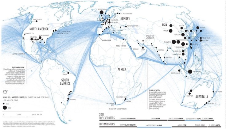
Commerce knits the modern world together in a way that nothing else quite does. Almost anything you own these days is the result of a complicated web of global interactions. And there’s no better way to depict those interactions than some maps.

Source: www.vox.com

Occasionally these lists that say something like “40 maps that…” end up being an odd assortment of trivia that is interesting but not very instructive; but I am of a fan of these list produced by Vox.  Not because they exhaustively explain the topic, but they give a strong visual introduction to a topic, such as this one on on the global economy.  


Tags: development, economic, globalization, industry, labor, unit 6 industry..

Welcome to the Anthropocene

“A 3-minute journey through the last 250 years of our history, from the start of the Industrial Revolution to the Rio+20 Summit. The film charts the growth of humanity into a global force on the equivalent scale to major geological processes.”

Source: www.youtube.com

Many geologists and other scientists now recognize that we are in a new geologic era.  This new era, called the Anthropocene, is distinguished by the fact that one species (homo sapiens), is dramatically modifying the environment. These modifications are impacting geologic processes to such a degree that this time period is geologically distinct (see this remote sensing interactive for examples of environmental change).  Paul Crutzen, a Nobel Prize–winning scientist who champions the term Anthropocene declared, “It’s no longer us against ‘Nature.’ Instead, it’s we who decide what nature is and what it will be.”  This video is a great primer for discussing the nature and extent of human and environmental interactions as related to industrialization, globalization and climate change.  This is definitely one of my favorite resources.


Tags: Anthropocenedevelopment, industryland use, environment, environment modify.  

The Transformation of Burning Man

“Burning Man takes place at the end of August every year in the barren and remote Black Rock Desert of Nevada. The weeklong festival is described by its organization as “an experiment in community, art, radical self-expression, and radical self-reliance.” Earth-bound photographers have chronicled the legacy of art, technology, design, and fashion at the event over the years, but we at Skybox wanted to know if we could capture the transformation of the city from space, with our constellation of SkySats. This is the result:

A full-fledged city of population 70,000, “Black Rock City” is built up in a matter of days, experienced for a single week, and disassembled just as quickly, leaving no trace.”

Source: www.skybox.com

Last week I posted about Burning Man, noting that the landscapes in this experimental culture are inherently ephemeral and fleeting.  High resolution satellite imagery has captured the quick rise and fall of the Black Rock City.  Perhaps the term ‘rise and fall’ might not aptly describe the formation and dismantling of a city of 70,000 people; it is more like the ebb and flow of the tide, certain to return again.  

Tags architectureimages, art, landscape, geospatial, remote sensing.

America is rapidly aging in a country built for the young

“Although we seldom think about them this way, most American communities as they exist today were built for the spry and mobile. We’ve constructed millions of multi-story, single-family homes where the master bedroom is on the second floor, where the lawn outside requires weekly upkeep, where the mailbox is a stroll away. We’ve designed neighborhoods where everyday errands require a driver’s license. We’ve planned whole cities where, if you don’t have a car, it’s not particularly easy to walk anywhere — especially not if you move gingerly.

This reality has been a fine one for a younger country. Those multi-story, single-family homes with broad lawns were great for Baby Boomers when they had young families. And car-dependent suburbs have been fine for residents with the means and mobility to drive everywhere. But as the Baby Boomers whose preferences drove a lot of these trends continue to age, it’s becoming increasingly clear that the housing and communities we’ve built won’t work very well for the old.”

Source: www.washingtonpost.com

Population change is frequently a concern of city planners at the local level.  This article shows that major demographic shifts are going to mean major changes in our patterns in our cities as we become a ‘greying’ society. 


Tagsurban, unit 7 cities, housing, sprawlneighborhood, planning, densityplanning, declining populations, population, demographic transition model, USA.

Moving Argentina’s Capital From Buenos Aires Could Make Things Worse

“Argentina should be careful in considering the implications of the idea of moving the capital [from Buenos Aires] to Santiago del Estero. While a dramatic move might be appealing as a fresh start, it could end up aggravating the challenges of governing the country. Capitals, like flags, are symbols, but their choice has very real consequences.”

Source: www.nytimes.com

Countries occasionally choose to move their capital cities to a region of the country where they want to promote growth.  A new capital such as the one being considered in Argentina, would be called by geographers a forward capital.  Although that term is not used in the article, it is one of the few examples of a forward capital being discussed a news article and it nicely discusses some of the advantages and disadvantages of forward capitals and the impacts they can have of regional growth, regime stability and the political organization of space.  


Tagspolitical, governanceArgentinaSouth America, unit 4 political.

Staking a claim to create a country

Jeremiah Heaton wants a no-man’s-land in east Africa, but international officials say his claim is insufficient.

Source: www.washingtonpost.com

This particular issue isn’t especially newsworthy, but it exemplifies some important principles of political geography with a tangible example to test the limits of political sovereignty and what it take to be called a country.  If discussing the elements necessary to create a state, this article would help fuel a discussion, especially when some people attempt to create their own micronation.    

Tagspolitical, states, unit 4 political.

Why this Ebola outbreak became the worst we’ve ever seen

“The 2014 Ebola outbreak in West Africa has killed more people than sum total of all the previous outbreaks since the virus was first identified in 1976. This video explains how it got so bad.”  

Source: www.youtube.com

In a word, geography.  The geographic factors facilitated the diffusion of Ebola and have slowed down the preventative measure and limited their success.  This shows how porous borders, cultural patterns of health care, limited facilities a low literacy rates all contribute to to creating this nightmare.

Tags: medical, development, diffusion, Africa.

Louisiana Loses Its Boot

The boot-shaped state isn’t shaped like that anymore. So, we revised its iconic outline to reflect the truth about a sin…

Source: medium.com

Maps shape how we think about places.  In mapping, we can reveal or conceal important pieces of information but sometimes the phenomena don’t fit the easy binaries.  In most places there is land, a coastline and then water (simple enough), but Louisiana’s coastline is much more complicated with large regions being more of a coastal zone than a neat line.  That accounts for some of the inaccuracies mapping Louisiana, but some lies are so convenient, that many people want the fiction to continue.  It is comforting to think about places as permanent, and admitting that it isn’t is acknowledging that there might be a problem.  As stated in this article, “the boot is at best an inaccurate approximation of Louisiana’s true shape and, at worst, an irresponsible lie.”  To explore the issue yourself, this gorgeous interactive map pulls together some high quality source materials on a wide range of issues to look at this environmental issues of this region in a holistic manner.

Tagsmappingcoastalenvironment, erosion, landscape., physical, fluvial.

Scottish Independence

“Scotland is about to vote on whether to secede from the UK. There are solid arguments on both sides.”

Source: www.youtube.com

Admittedly, this video is filled with stereotypes, bad words and a strong political bias all delivered in John Oliver’s trademark style–it’s also filled with incorrect statements which I hope most people can recognize as humor, but it captures college students’ attention.  If, however, you are looking for a more insightful piece, I recommend Jeffrey Sach’s article titled “The Price of Scottish Independence.”  Independence in Europe today doesn’t mean what it used to, and this vote will be fascinating regardless of the outcome.    


Tags: devolution, supranationalism, politicalEurope, UK..

Create a free website or blog at WordPress.com.

Up ↑