Search

GEOGRAPHY EDUCATION

Supporting geography educators everywhere with current digital resources.

New York Public Library Puts 20,000 Hi-Res Maps Online

See on Scoop.itGeography Education

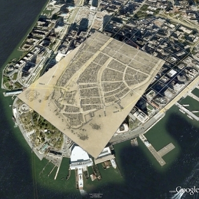
“When I was a kid, my father brought home from I know not where an enormous collection of National Geographic magazines spanning the years 1917 to 1985. I found, tucked in almost every issue, one of the magazine’s gorgeous maps—of the Moon, St. Petersburg, the Himalayas, Eastern Europe’s ever-shifting boundaries. I became a cartography enthusiast and geographical sponge, poring over them for years just for the sheer enjoyment of it, a pleasure that remains with me today.  Whether you’re like me and simply love the imaginative exercise of tracing a map’s lines and contours and absorbing information, or you love to do that and you get paid for it, you’ll find innumerable ways to spend your time on the new Open Access Maps project at the New York Public Library.”

See on www.openculture.com

Logging and Mudslides

See on Scoop.itGeography Education

In recent decades the state allowed logging — with restrictions — on the plateau above the Snohomish County hillside that collapsed in last weekend’s deadly mudslide.

Seth Dixon‘s insight:

There are several reasons for mudslides–some are purely a result of physical geography and others are related land use patterns.  This last week’s mudslide in Washington state was a combination of the two and although this impacts one place (see on map), it is a good teaching moment to discuss the environmental impacts of land use patterns and resource extraction projects.  As seen in this interactive, the river was cutting at the base of the hill, while loggers were clear-cutting at the top of the mountain.  Trees help prevent erosion as the roots hold the soil in place–a critical piece to the puzzle in a very rainy climate.  With $1 million worth of timber on the slope, logging companies persisted despite objections from the Department of Natural Resources and some restrictions (but in hindsight, those restrictions clearly were not enough).

View the impact in ArcGIS online: Before and After Swipe, LiDAR I and II, and Imagery.

Questions to Consider: Other than economic worth, what other ways are there to value and evaluate the environment?  How could this landscape have been protected and managed better or was this mudslide inevitable?   

Tagspolitical ecology, resources, environment, environment modify, industry, physical, geomorphology, erosion, landforms.

See on seattletimes.com

Mudslide

Coast to Coast: Baseball Hall of Fame Geography Lessons

The history of baseball reflects the story of expansion in the United States. New cities have emerged and modern stadiums have been built as a growing population fueled the popularity of our National Pastime. The result is an extensive network of baseball teams at every level – from the major leagues to the little leagues – that represent the communities and environments in which they play. Everything from jersey colors, names, and symbols to the foods served at ballparks reflects the local landscape and culture of baseball teams. A simple game that began with a bat and ball is now a comprehensive case study of how people and geography are interrelated.

 
All of the lessons and activities have been prepared to accompany “Geography: Baseball Coast to Coast.” You will find that the curriculum is organized into three levels: Level 1 for elementary school students, Level 2 for middle school students, and Level 3 for high school students.

Seth Dixon‘s insight:

Thanks to the NCGE and the Baseball Hall of Fame for working together to bring us these great resources…play ball!!

See on baseballhall.org

Yellowstone National Park rattled by largest earthquake in 34 years

Yellowstone National Park, which sits atop one of the world’s largest super-volcanoes, was struck on Sunday by a magnitude 4.8 earthquake, the biggest recorded there since February 1980, but no damage or injuries were immediately reported.

Seth Dixon‘s insight:

The amazing geothermal activity in Yellowstone National park annually brings thousands of tourists to the region.  The reason why these geysers, hot springs and fumaroles are there is because of the what is just below the surface.  Watch a video (the 2 minute version or a 44 minute version) to see why this natural wonder is also a major geologic threat for earthquake and volcanic activity, which explains the reasons for this weekend’s earthquake. 

See on www.reuters.com

Place and Opinions

Seth Dixon‘s insight:

Some deeply held opinions that individuals hold are rooted in the cultural and regional influences (even if they feel that they are being purely objective).  Sports fans though, are rarely objective and are often swayed by those opinions that they hear the most, which often come for those closest to us.  While we are on the subject of basketball and geography, you’ve got to try Population Bracketology, which challenges your knowledge on the sizes of Metropolitan Statistic Areas and state population.     


Tags: fun, sport, place.

See on espn.go.com

Changing Earth

Over the years, ISS astronauts have had a rare opportunity to witness climate change on Earth from space.

Seth Dixon‘s insight:

This video from National Geographic goes nicely with some of my recent posts about the dramatic changes that can be seen as some cities have exploded on the international scene.  The changes in metropolitan areas are dramatically presenting using satellite imagery in this great teaching video. 

See on video.nationalgeographic.com

What makes geography grads the most employable?

We asked our experts why they thought geography and psychology graduates were found to be least likely to be unemployed

Seth Dixon‘s insight:

Some studies have shown that geography graduates are some of the least likely to be unemployed…what makes geography majors so employable?  The mix of skills without one career track makes geography majors able to land on their feet in a shifting economic landscape.  If you wondering about job possibilities for geography majors, here is a list designed to answer the question, “what can I do with a geography degree?”  More than you might think. 

See on careers.theguardian.com

Will Ethiopian dam dry up the Nile?

“Construction of the Grand Ethiopian Renaissance Dam (known as Gerd) is now about 30% complete.  Once completed, in three years, it will be Africa’s largest hydropower dam, standing some 170m (558ft) tall.”

Seth Dixon‘s insight:

Located near the border with Sudan (see in Google Maps), Ethiopia plans to dam the Blue Nile before the water heads to Sudan and eventually into Egypt.  As stated in this BBC article (with a nice 1-minute video clip), Egypt and Sudan currently get the majority of the Nile’s waters because of colonial-era treaties and Egypt is opposed to Ethiopia’s plan, fearing their water supply with be threatened. 


Tags: Ethiopia, Africa, development. environment, water, environment modify, energy, borders, political.


See on www.bbc.com

Circles of Latitude Craft

Hands-on worksheet to play and review the circles of latitude from the Wise Nest.”

Seth Dixon‘s insight:

I originally found this hands-on activity on Maps 101 wanted to make my own.   This is a fun way to make latitude more meaningful and memorable.  All the documents you need to recreate this, and to have your students make their own are available here

See on www.youtube.com

Blog at WordPress.com.

Up ↑