Search

GEOGRAPHY EDUCATION

Supporting geography educators everywhere with current digital resources.

The Great Language Game

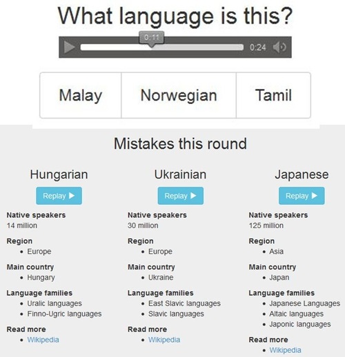
Challenge yourself to identify some seventy languages by their sound alone. Learn more about how languages sound and where they’re spoken.

Seth Dixon‘s insight:

This is a great game that let’s you first listen to and then attempt to identify the language that is being spoken.  What’s even better, you have “three lives” and after the game is complete, you will be provided with the more information about the languages that you were not able to identify. 


Tags: language, culture, trivia, games.

See on greatlanguagegame.com

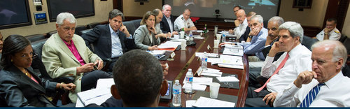
Debating the U.S. Response to Syria

Students will:

  • Analyze the issues that frame the current debate on U.S. policy towards Syria.
  • Consider the role of the U.S. public, the president, and Congress in the decision of whether to use military force.
  • Work cooperatively within groups to integrate the arguments and beliefs of the options into a persuasive, coherent presentation.
  • Explore, debate, and evaluate multiple perspectives on U.S. policy towards Syria through a role-play activity.

Seth Dixon‘s insight:

You want resources for teaching the most important geopolitical issue right now?  This set of resources from the Choices Program is just what you are looking for. 

Tags: Syria, MiddleEast, conflict, political.

See on www.choices.edu

National Geographic Found

“FOUND is a curated collection of photography from the National Geographic archives. In honor of our 125th anniversary, we are showcasing photographs that reveal cultures and moments of the past. Many of these photos have never been published and are rarely seen by the public.  We hope to bring new life to these images by sharing them with audiences far and wide. Their beauty has been lost to the outside world for years and many of the images are missing their original date or location.”

Seth Dixon‘s insight:

How have I not found National Geographic FOUND until now?  The curators post approximately 2 pictures a day that generally have never been published before; the result is an archive that is a wonderfully eclectic treasure trove.  There are simply too many great teaching images to share them individually.  Pictured above is the Sutherland Falls which thunders down a 1,904-foot drop from Lake Quill in New Zealand (January 1972, Photo by James L. Amos).  I consider National Geographic FOUND as a must see and will include it in my list of best scoops (filed under the tag zbestofzbest). 

Tags: perspective, National Geographic. images, zbestofzbest.

See on natgeofound.tumblr.com
What Pollution? Hong Kong Tourists Pose With Fake Skyline

Picture this: Tourists visiting one of your city’s most prominent attractions are unable to see it because of smog, haze and a bevy of other airborne pollutants. What’s the solution?

Seth Dixon‘s insight:

Pollution is becoming ubiquitous in our urban environments.  If your primary concern is the environment, it is clear that this situation in Hong Kong must be changed.  But what if the environment is not the concern of policy makers?  What economic and planning arguments could you make in favor of a more sustainable course?

Tags: pollution, China, development, economic, megacities, East Asia, industry, sustainability, urban ecology.

See on www.huffingtonpost.com

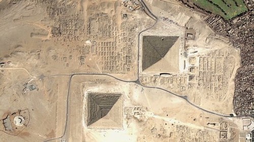
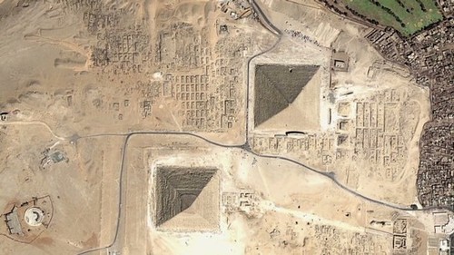
Space archaeologist unlocks secrets of ancient civilizations

Dr Sarah Parcak uses satellite technology to unearth Egypt’s ancient settlements, pyramids and palaces lost in the sands of time.

Seth Dixon‘s insight:

The uses of geospatial technologies are NOT limited to studying geography, but it is the bedrock of many research projects that involve spatial thinking (as demonstrated in this CNN article and the TED talk below).  Geographic principles and geographers can be very important components of interdisciplinary research teams.

Tags: spatial, remote sensing, geospatial, Egypt, historical. 

See on edition.cnn.com

Picture quiz – do you know your world cities?

Some city skylines are so iconic they are instantly recognisable.

Seth Dixon‘s insight:

This is a quiz that leaves out the most obvious contenders (London, Paris, NYC etc.) in a gallery of cities around the world – it’s harder than you might expect.  Can you recognize the city just from a skyline?

Tags: urban, landscape, place, trivia.

See on www.theguardian.com

Hijab: Veiled in Controversy

Hijab is an Islamic concept of modesty and privacy, most notably expressed in women’s clothing that covers most of the body.

Seth Dixon‘s insight:

What is the geography of hijab?  Covering one’s head pre-dates Islam in the Middle East but many associate this practice strictly with Islam and only for women–read this article (with teaching tips and supplemental resources) for more context on this cultural and religious practice.

Tags: Islam, perspective, religion, culture, National Geographic.

See on education.nationalgeographic.com

Stanford History Education Group

Seth Dixon‘s insight:

The Stanford History Education Group has amassed some great resources for social studies teachers.  Their chief resources is a program called Reading Like a Historian.  The program has 71 stand-alone lessons for U.S. History organized within 11 units. These lessons span colonial to Cold War America and cover a range of political, social, economic, and cultural topics. They are continuing to expand the Reading Like a Historian program to World History.  Currently there are 15 lessons from across the world history sequence with more lesson plans under development that will be released in the next few months.

Tags: historical, teacher training.

See on sheg.stanford.edu

Complexity in Syria

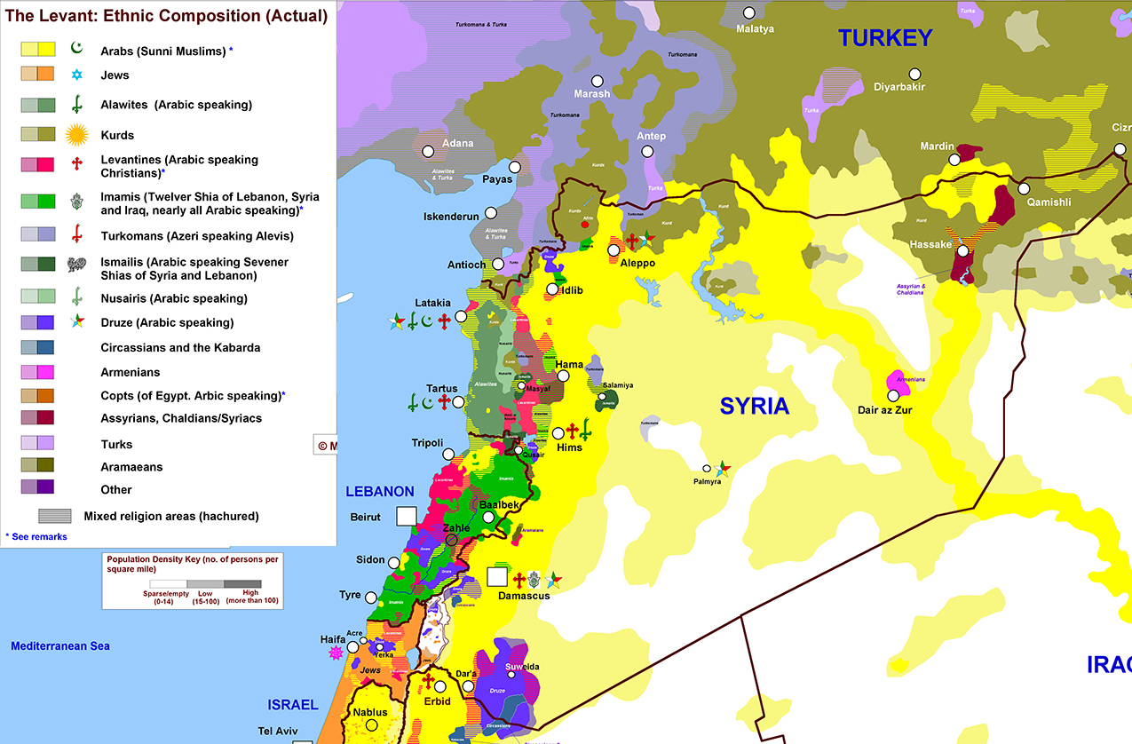
A color-coded map of the country’s religious and ethnic groups helps explain why the fighting is so bad.

Seth Dixon‘s insight:

This map of the various ethnic and religious groups in being shown on major media outlets and some Western countries including the United States are considering military action in Syria.  This map powerfully conveys while many may conceptualize Syrians as a single monolithic group, that idea is a fiction that was created in the absence of geographic content to fill the void. 

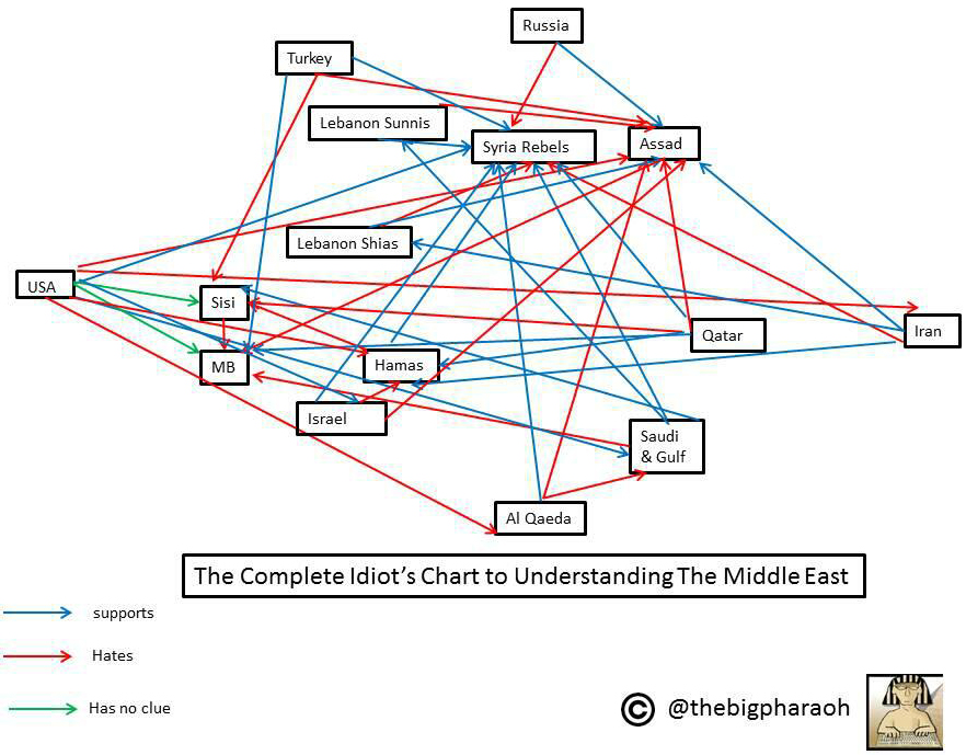
DIAGRAM

Additionally this diagram has also been circulating lately for the same reasons; this flow chart lays out the Middle East’s political rivalries and alliances.  “The enemy of my enemy is my friend” is a well-quoted proverb to simplify Middle Eastern political alliances and rivalries.  Seeing this web, you can only imagine that living by that dictum can certainly lead to complicated geopolitical conflicts among countries and culture groups.


Tags: Syria, MiddleEast, conflict, political, ethnicity, religion.

See on www.washingtonpost.com

Levant_Ethnicity_lg-smaller1-zoom

Blog at WordPress.com.

Up ↑