Supporting geography educators everywhere with current digital resources.
Source: www.scoop.it
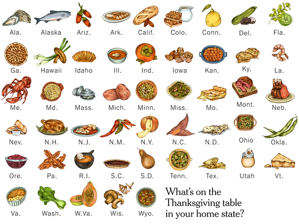
Looking for some Thanksgiving resources? Here you go.
Tags: Thanksgiving, food, seasonal.
Supporting geography educators everywhere with current digital resources.
Source: www.scoop.it
Looking for some Thanksgiving resources? Here you go.
Tags: Thanksgiving, food, seasonal.
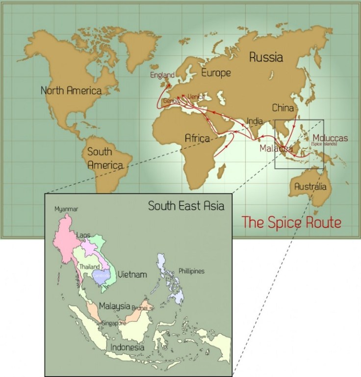
“In its day, the spice trade was the world’s biggest industry. It established and destroyed empires and helped the Europeans (who were looking for alternate routes to the east) map the globe through their discovery of new continents. What was once tightly controlled by the Arabs for centuries was now available throughout Europe with the establishment of the Ocean Spice Trade route connecting Europe directly to South Asia (India) and South East Asia.”
Source: cleanfooddirtygirl.com
The spice trade changed how we eat forever but it did so much more. The fall of Constantinople to the Ottoman Empire cut off Europe from the vital trade routes to the east and access to the most prized commodities of the day. What drove European exploration to get around Africa and to cross the Atlantic? It was to reshape their situation location relative to the economic networks that shaped the emerging global economy. In essence, the spice trade reshaped the fortunes and trajectories of several major world regions.
Tags: Southeast Asia, food production, diffusion, globalization, agriculture, economic, industry, economic, historical, regions.
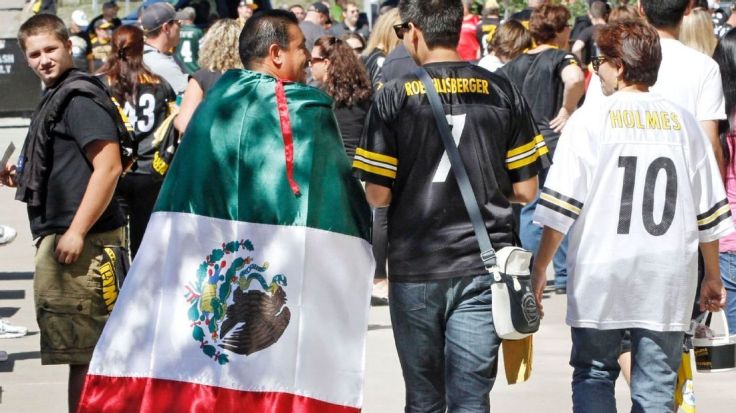
“Why is the NFL in Mexico? A visitor to the capital city can sense right away why the league is so bullish on the country’s potential.”
The last time the NFL ventured into Mexico was in 2005, when the Arizona Cardinals beat the San Francisco 49ers in Estadio Azteca. Top-level American football is returning to the same venue in Mexico City on Monday night, when the Houston Texans and Oakland Raiders will face off in a contest that has been sold out since July.
Just don’t assume the 11-year gap is related to a lack of interest. In reality, Mexico is the top international hotbed for American football, with the largest NFL fan base of any country outside the United States. There are more fans of the league in Mexico City than in most actual NFL markets.
But the sport’s popularity in Mexico goes well beyond NFL fandom. From youth leagues that are overtaking soccer in popularity in some parts of the country to a new pro league, American football is a major player south of the border. With that in mind, here’s a closer look at where the sport stands on every level in Mexico and how fans there consume the game.
Tags: sport, popular culture, diffusion, culture, Mexico, Middle America.
Source: www.espn.com
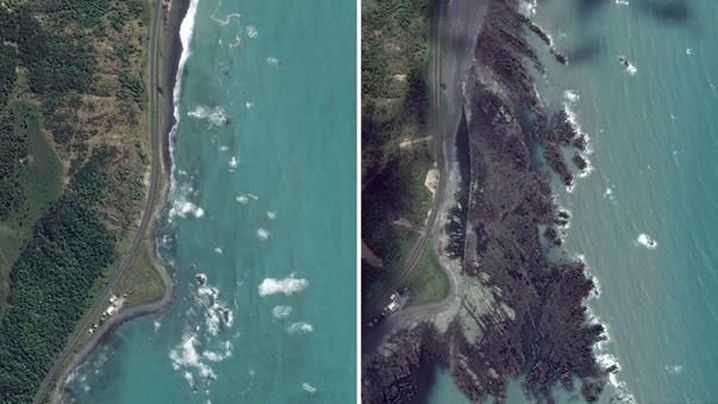
The 7.8 magnitude earthquake that hit New Zealand’s South Island lifted up the seabed by two metres, pushing it above the ocean’s surface.
Source: www.9news.com.au
Plates on the Earth’s crust typically move forward at very slowly (about the same speed as the fingernail growth). While that is the usual, plates snag along the edges and pressure can build over the years, only to lead to explosive, quick changes like happened recently in New Zealand. This complex series of tremors has people disconnected as much of the physical infrastructure has be damaged.
Tags: New Zealand, physical, tectonics, transportation, geology, geomorphology.
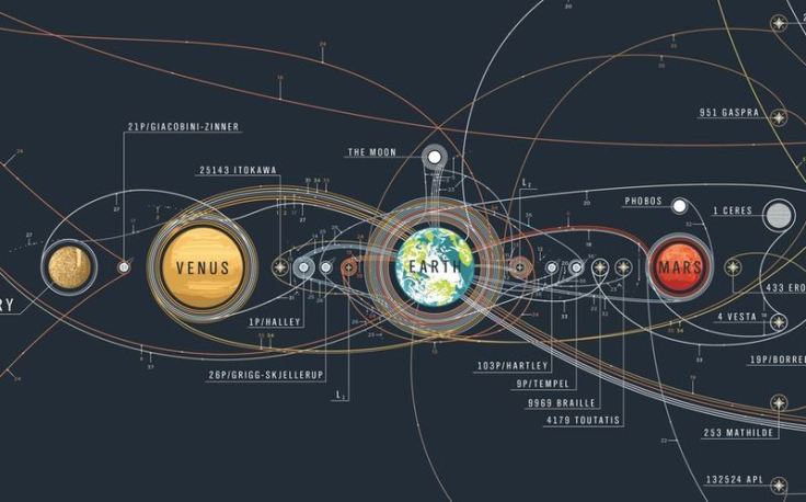
“Humans have dreamed about spaceflights forever but only in the second half of the 20th century were developed rockets that were powerful enough to overcome the force of gravity to reach orbital velocities that could open space to human exploration. The awesome poster called Chart of Cosmic Exploration documents every major space mission starting from the Luna 2 in 1959 to the DSCOVR in 2015. The map traces the trajectories of every orbiter, lander, rover, flyby, and impactor which ever left the Earth’s orbit and successfully completed its mission.”
Tags: space, remote sensing, scale.
Source: geoawesomeness.com

District of Columbia voters passed the referendum Tuesday with nearly 80 percent in favor. Congress, which will ultimately decide the fate of the federal district, is not expected to approve it.
Voters in the District of Columbia passed a measure on Tuesday in favor of petitioning Congress to become a state in the union.
79 percent of voters cast votes in favor of the ballot measure, which splits the district into a residential state with a small federal district in the middle of it for government buildings and monuments, as we have reported.
The newly approved measure had four parts:
Source: www.npr.org
Questions to Ponder: Why do the residents of the District of Columbia want to change the legal status of the District to a state? Why might some states and politicians NOT want to see a 51st state? What is needed in the United States to admit a new state (Puerto Rico is still a possibility to become the 51st state)?
Tags: political, sovereignty, autonomy, Washington DC.
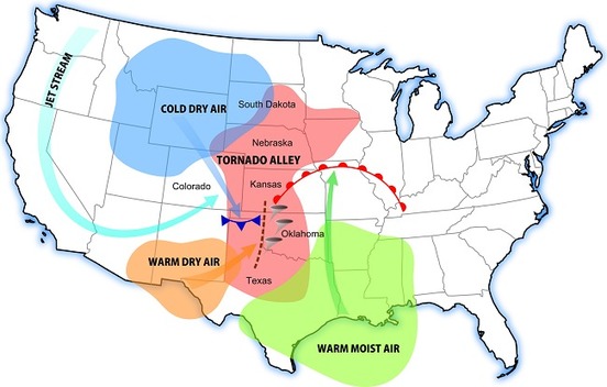
Interested in learning about tornado alley? Then you’ll want to read our tornado alley facts and information. Tornado Alley 101
Source: www.tornadofacts.net
This map nicely shows the particular air requirements needed for a tornado to form and why the part of the United States known as Tornado Alley accounts for the majority of the world’s tornadoes. This nicely shows how physical geographic factors form a major part of how a region might be defined and conceptualized.
Tags: tornado, physical, weather and climate, visualization, regions.
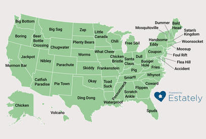
A map produced by real estate website Estately found the weirdest town name for every state in America, including Booger Hole, WV, and Old Roach, CO.
Source: www.thrillist.com
I know, I know. You have a better name that should be on this map of strange toponyms. Having driven MANY times from San Diego to Utah, I’m kind of partial to Zzyzx, CA…just because. What’s you favorite toponym? What value is there is having a strange name for a town? How does a place name contribute to the local sense of place?
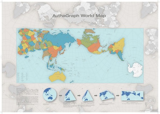
“To design a map of the world is no easy task. Because maps represent the spherical Earth in 2D form, they cannot help but be distorted, which is why Greenland and Antarctica usually look far more gigantic than they really are, while Africa appears vastly smaller than its true size. The AuthaGraph World Map tries to correct these issues, showing the world closer to how it actually is in all its spherical glory.”
Source: mentalfloss.com
This just shows how subjective the concept of “accurate” can be. First off, this is a fabulous map that nicely minimizes distortions (distance, direction, area, and shape) of the land on our planet. Any criticism of the map just shows the impossibility of making an accurate 2D map of a 3D Earth, but I still think that there is plenty of room to discuss the flaws/distortions that were chosen instead of others. It is interesting to note that a Japanese contest awarded this map with it’s top honor (I doubt a Brazilian organization would feel the same way about this map). This map does make with some traditional cartographic conventions in its representation of Earth.
Questions to Ponder: What are some elements of this map that are different from more traditional maps? This map claims to be more accurate; does that make it more useful?
Tags: visualization, mapping, cartography, geospatial, technology.


