Search

GEOGRAPHY EDUCATION

Supporting geography educators everywhere with current digital resources.

The Depths of the Unseen Ocean

“The depths below the ocean’s surface comprise a staggering 95 percent of the Earth’s living space, and much of it is unexplored by humans. To put into perspective just how deep the oceans go, this XKCD comic, (hi-res image).  Most of the ocean doesn’t even see sunlight. Even scientists aren’t familiar with everything that’s down there.”

Source: www.sciencealert.com

XKCD is a comic strip that deals with many intellectual issues, but it can also be a wealth of quality scientific information.  This infographic on the oceans is staggering.


Tags: XKCD, artinfographic, physical, environmentwater.

FARC-Colombia peace deal finalized

Negotiators seeking to end the insurgency in Colombia, one of the world’s longest-running conflicts, said they had reached a final peace deal.

Source: www.cnn.com

Farclandia has long been an insurgent state where the Colombian government had no real power to enforce the rule of law and their sovereignty over this area that all the political maps say are Colombia.   This shadowy place became a place where drug cartels could operate freely and many of the concessions that Colombia is making for this deal to happen involve amnesty for past crimes. 


TagsSouth America, Colombiapoliticalnarcotics. conflict.

Map Men: teaching geography through comedy

Mark Cooper-Jones and Jay Foreman, the Map Men, tap into a rich vein of geographical quirks to teach through comedy

Source: geographical.co.uk

Why am I just now finding out about this resource?!?  This new YouTube channel is full of promise for geography teachers…fun, quirky, full of interesting trivia, but most importantly, these videos are rooted in geographic concepts. 


Tags: mappingfun, videoAPHG, geography education, unit 1 GeoPrinciples.

The 20 Most Bike-Friendly Cities on the Planet

Investment in bicycle infrastructure is a modern and intelligent move. Many cities get this. Many don’t.


Tags: urbanplace, transportationplanning, urbanism, architecture.

Source: www.wired.com

Katahdin Woods and Waters National Monument

//cdn.embedly.com/widgets/media.html?src=https%3A%2F%2Fplayer.vimeo.com%2Fvideo%2F180047331&wmode=opaque&url=https%3A%2F%2Fvimeo.com%2F180047331&image=https%3A%2F%2Fi.vimeocdn.com%2Fvideo%2F588145027_1280.jpg&key=359ed8ab27db4f02a128049b1f89d6a1&type=text%2Fhtml&schema=vimeo

“President Barack Obama designated tens of thousands of acres of Maine forest as a national monument on Wednesday, one day before the 100th anniversary of the National Park Service.  The area, known as the Katahdin Woods and Waters National Monument, spans 87,500 acres of the state’s stunning northern woods. The area is named for Mount Katahdin, which is Maine’s highest mountain and is located within the adjacent Baxter State Park.”


Tags: conservation, physical, biogeography, environment.

Source: vimeo.com

Unlocking The National Mall

Lisa Benton-Short, author of The National Mall: No Ordinary Public Space talks about the overlooked urban National park sites, getting inspired by her own neighbourhood, and more.

Source: utpblog.utpress.utoronto.ca

The National Mall has been transformed so much in that last 200 years.  Lisa Benton-Short, in this interview about her book says, “The Mall has been a place where I connect to American history and identity, and our country’s founding principles and ideals. It is place where you can feel the power of the monuments and memorials, the legacy of events, marches and protests. The Mall is an incredibly meaningful place. This book is the result of my intellectual curiosity as a scholar, but also my personal attachment to this place.”


Tags: historicalspace, monumentsplace, landscape.

Fertility Rates-Differences Within Countries

pastedImage3593-467x550

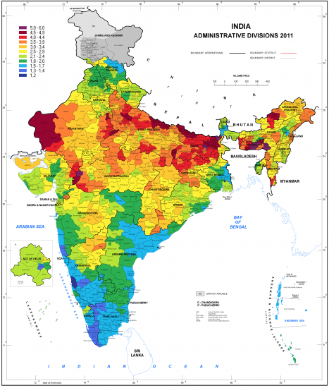
“An important aspect about country level data of fertility to keep in mind is that there can be considerable heterogeneity within countries, which are hidden in the mean fertility which were discussed in this entry. The mean Total Fertility Rate for India in 2010 was 2.8 (UN Data): But this average hides the fact that the fertility in many Southern Indian regions was below 1.5 (which is similar to the mean fertility in many European countries), while the fertility in Northern India was still higher than 5 children per woman (which is as high as the mean of the African countries with the highest fertility).”

Source: ourworldindata.org

This is a stunning example of uneven development and regional differences within countries.  Too often we discuss countries as if the situation inside the borders of one country is the same throughout it, even if the geographic contexts can be wildly different. 

Questions to Ponder: Why are the fertility rates in so different in northern and southern India?  How does this regional imbalance impact the country?  What are other examples of major differences within a country? 

Tags: regions, population, demographic transition model, declining populationmodelsunit 2 population, India, South Asia. 

Olympic Races, in Your Neighborhood

“What would Olympic races look like if they took place near you? Enter your address below to find out, or keep clicking the green button to explore races that begin in where you live.”

Source: www.nytimes.com

I thought I was done with the Olympics, but this just sucked me right back in…in the most geographically relevant way possible.  Scale and distance are important geographic concepts and realizing JUST HOW FAST these Olympians are on the TV can be deceptive when they are paired up with other great Olympians.  Seeing how far in your own neighborhood you would have to go to beat the 400m champion–or the 5000m.  Since the United States doesn’t use the metric system, this map is a good way to contextualize these measurements and try to run the race in your own backyard.  Let the Backyard Games begin!!


Tags: mappingfunscaledistance, sport, unit 1 GeoPrinciples.  

Bangladesh’s Hazardous Geography

Bangladesh is exposed to threat of hazards resulting from a number of natural disasters and remains classified as one the most vulnerable countries. Majority of the country is affected by cyclone, drought and floods.

Source: www.saarc-sadkn.org

Bangladesh is regularly hit with different types of natural disasters. The impact of these natural disasters costs the country millions making it dependent on foreign aid.  Disaster clean-up and relief aid after major floods, droughts, and hurricanes.  


Tagsdisasters, environmentBangladeshSouth Asia, development.

Blog at WordPress.com.

Up ↑