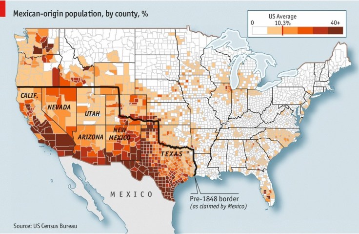
Search

GEOGRAPHY EDUCATION

Supporting geography educators everywhere with current digital resources.

Tag

borders

The Most Complex International Borders in the World

“In this video I look at some of the most complex international border. Of course, there are more complex borders in the world, but this video looks at some of my favourites.”

Source: www.youtube.com

This video shows some great examples of how the political organization of space and administration of borders can get complicated.  Here are the examples (and time in the video when they are covered in the video):


Tags: borders, political, territoriality, sovereignty, video.


The Toll in Gaza and Israel, Day by Day

The daily tally of rocket attacks, airstrikes and deaths in the conflict between Israel and Hamas.

Source: www.nytimes.com

As the violent nature of the Israeli Palestinian conflict has escalated, this NY Times article monitors the major points of the last few weeks.  The possibility of ‘Peace in the Middle East’ feels so remote, and this Onion article parodies the difficulties of actually achieving this.  On a personal note, Chad Emmett taught the “Geography of the Middle East” course while I was at BYU and I’ve always appreciated his perspective; here are his thoughts on recent events.  


Tags: Israel, Palestine, conflict, political, borders.

Challenges in Defining an Israeli-Palestinian Border

There are major hurdles in drawing borders between Israel and a future Palestine.

Israeli and Palestinian negotiators resumed peace talks in Washington in July for the first time in three years. While the talks are initially expected to focus on procedural issues, they are already beginning to take on a last-ditch quality. Explore some of the contentious issues that negotiators have faced in drawing borders between Israel and a future Palestinian state.

Source: www.nytimes.com

This five-part video report from the New York Times is from 2011, but still has some pertinent information, even if the situation has changed in some of the particulars.  These videos brings important voices from a variety of perspectives on the Israeli-Palestinian conflict; together they all  show how a complex cultural and political geography leads to many of the difficulties in creating a long-lasting peace.  The discipline of geography doesn’t simple study the peace process–it is a part of it.  The creation of borders and the cartographic process play a critical role in solving territorial issues.  Geography can be both the problem and the solution. 

Tags: Israel, borders, Palestine, territoriality, political, Middle East.

Ethiopia’s Dam Problems

“Ethiopia is three years from completing a dam to control its headwaters, and while Egypt points to colonial-era treaties to claim the water and to stop the project, the question remains as to who own the Blue Nile.”

Source: maps101blog.com

This 7-minute Geography News Network podcast (written by Julie and Seth Dixon) touches on some key geographic concepts.  85% of the Nile’s water comes from the Blue Nile that originates in the Ethiopian highlands–it is the Blue Nile that Ethiopia has been working on damming since 2011.  The Grand Ethiopia Renaissance Dam (GERD) will be located  near the border with Sudan.  Egypt is adamantly opposed to Ethiopia’s plan and is actively lobbying the international community to stop construction on the dam, fearing their water supply with be threatened. 

Tags: Ethiopia, Africa, development. environment, water, energy, borders, political.

Where Do Borders Need to Be Redrawn? – Room for Debate

What parts of the world should rethink their maps? Why and how?

Source: www.nytimes.com

Maps are always changing as a new nation gets added and old lines cease to make sense. Territory is claimed and reclaimed.  This series of seven articles in the New York Times explores regional examples of how borders impacts places from a variety of scholarly perspectives.  Together, these article challenge student to reconsider the world map and to conceptualize conflicts within a spatial context.


Tags: bordersmapping, political, territoriality, sovereignty.

China publishes new map

China has published a new map of the entire country including the islands in the South China Sea (West Philippine Sea) in order to “better show” its territorial claim over the region.

Source: globalnation.inquirer.net

China is attempting to bolster its geopolitical claims through cartographic validation.  It as if to say, ‘it’s on a map, who can question that it is legitimately our territory?’  Why is a map such a powerful and convincing document?  Why is the Philippines upset by this map?  I think that explains this rival Filipino map as the Philippines and China engage in the cartographic version of dueling banjos.  (note the uage of the South China Sea or West Philippine Sea to refer to the same body of water) .  But this is more than just a map; it’s production has the potential to destabilize regional security.     

For more resources, the Choices Program has put together supplemental materials to investigate China on the world stage.

Tags: borderstoponyms, political, conflict, waterChina, East Asia.

Would Turkey accept a Kurdish state?

As the likelihood of an independent Kurdish state on Turkey’s eastern border grows, Ankara is losing its historical resistance to the idea.

Developments in Iraq have left Turkey facing the prospect of an independent Kurdish state on its eastern border. Such an idea would have been abhorrent for Turkey a mere decade ago for fear that its existence would incite separation among its own restive Kurds. The standard Turkish narrative at the time was that an independent Kurdistan was a Western project aimed at destroying Turkey, an age-old ambition. Even the 2003 US invasion of Iraq was viewed in this context by many. The picture is no longer so black and white.

Source: www.al-monitor.com

Lies Your World Map Told You: 5 Ways You’re Being Misled

“Unfortunately, most world political maps aren’t telling you the whole story. The idea that the earth’s land is cleanly divvied up into nation-states – one country for each of the world’s peoples – is more an imaginative ideal than a reality. Read on to learn about five ways your map is lying to you about borders, territories, and even the roster of the world’s countries.”

Source: www.polgeonow.com

This is a nice article to get students to look past the officialness of a world map to explore some of the complexities that make contemporary political geography so compelling.  In a nutshell, this article discusses 5 major themes:

  1. Missing countries
  2. Incomplete control
  3. Undefined borders
  4. Disputed territories
  5. Territorial seas

Tags: bordersmapping, political, territoriality, sovereignty.

African borders

“About the history of the creation of Africa borders and debates about African borders.”

Source: mycontinent.co

Disregard the rough English grammar; this is a nice article to show some of the historical, ethnic, linguistic and political complexities behind African borders.  This would be a great supplemental article to help AP Human Geography students to prepare for Question 2 of the 2014 AP Human Geography Exam that focused on superimposed boundaries within an African context.  

TagsAPHG, language, Africa, colonialism, borders, political.

Blog at WordPress.com.

Up ↑