Search

GEOGRAPHY EDUCATION

Supporting geography educators everywhere with current digital resources.

Tag

economic

Providence area sees biggest shift away from manufacturing jobs in US

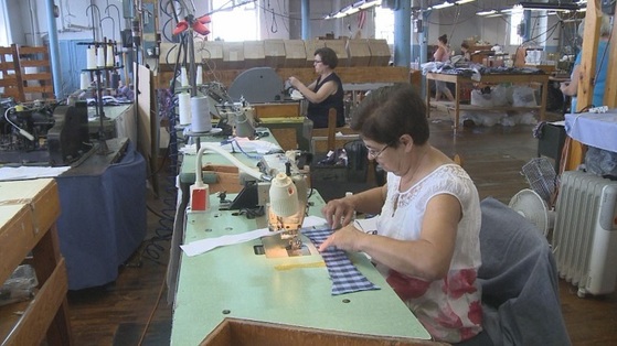
A new study illustrates just how drastically employment has plunged in Rhode Island’s historic industrial base over recent decades. Since 1980, the Providence metropolitan area has experienced the largest shift in the country away from manufacturing jobs and into work requiring college degrees, according to a paper by Stephan Whitaker, a research economist at the Federal Reserve Bank of Cleveland. “In 1980, 40% of workers in the Providence metro area worked in manufacturing and 25% worked in degree-intensive fields,” Whitaker writes. “By 2014, manufacturing had dropped to just 11%, and degree-intensive jobs had risen to 47%.”


Tags: urbanindustrymanufacturinglabor, economic, Rhode Island.

Source: wpri.com

China sends first freight train to London

Time for a long trip along the new silk road.


The train is part of Chinese President Xi Jinping’s vision for ‘One Belt, One Road’ — dubbed by some as the new silk road. It’s China’s infrastructure initiative, which Xi hopes will improve China’s economic ties with Europe, Asia and the Middle East.


Tags: regions, transportationeconomic, globalization, diffusion, industry.

Source: www.cnn.com

The Staggering Wealth Of Mexico City

Walk on the streets and you´ll be exposed to its informal economy: people who do what they can to eke out a living including washing windshields, selling food, or even singing, dancing, and performing acrobatics for a tip.

What Americans may not know is that Mexico City is home to the wealthiest people, the poshest neighborhoods, the most exclusive shops, entertainment venues, and cultural centers on the planet.

Source: xpatnation.com

Mexico City has been the economic center of Mexico for a long time and is a true primate city. “Wealth accumulation in Mexico City has historically been concentrated in the hands of a few. In colonial times, the elite was mostly composed of Spanish-born immigrants who held high-ranking offices or worked as business owners or export-oriented merchants. Later, the wealthy were those who owned large estates known as haciendas…It is estimated that around 40 percent of Mexico’s income is owned by just 10 percent of its population, while 52.3 percent of Mexican citizens live in poverty.”


Tags: urban, megacitieseconomic, labor, Mexico.

The Final Days Of Hawaiian Sugar

The sugar industry in Hawaii dominated the state’s economy for over a century. But it has shrunk in recent years. Now, the last of the state’s sugar mills has wrapped up its final harvest.

Source: www.npr.org

I grew up hearing commercials that sold the purity of the Hawaiian sugar Industry (C & H, Pure Sugar, that’s the one!).  These commercials sold not just the purity of Hawaii’s sugar, but also of the people and the place.  These commercials were some of my first geographic imaginings of an exotic tropical paradise on the peripheral edge of the United States.  Just like the imagined tropical bliss, the actual sugar industry of Hawaii is also coming to an end.  “For over a century, the sugar industry dominated Hawaii’s economy. But that changed in recent decades as the industry struggled to keep up with the mechanization in mills on mainland U.S. That and rising labor costs have caused Hawaii’s sugar mills to shut down, shrinking the industry to this one last mill.”   


Tags: industrymanufacturinglabor, economic, agribusiness, agriculture.

America’s ‘Megaregions’ using Commuter Data

New maps use math to define the amorphous term.

Source: www.citylab.com

By now I’m sure many of you have seen some iteration of this research and data visualization circulating through social media outlets (you can see the article from City Lab, Atlas Obscura or an urban planning program).  We use terms like the greater metropolitan area to express the idea that areas beyond the city boundaries and even beyond the metropolitan statistical areas are linked with cities.  These ‘mega-regions’ are in part the hinterlands of a city, a functional region where the cities act as hubs of economic regions.   

Tags: regions, urban, transportationeconomicvisualization, mapping, USA, planning.

Los Lakers know their Hispanic fan base

“With timely assists from the Spanish-speaking skills of players and executives, the Lakers have cultivated Hispanic support in their community.”


Julio Manteiga, associate director of media monitoring and Latin America communications for the NBA, provided ESPN information stating Hispanic fan attendance for Lakers games was 42 percent. In the 2015 U.S. Census, the Hispanic population of Los Angeles County was measured at 48.4 percent. The Lakers have benefited from taking the initiative to make their games accessible to a Latino audience, starting with broadcasting games in Spanish.


Tags: culture, economic, California, Los Angeles, ethnicity, sport, popular culture,

Source: www.espn.com

America’s Wealth Is Staggeringly Concentrated in the Northeast Corridor

“At the county level, America is a tremendously unequal place.”

Source: www.citylab.com

The concentration of wealth within U.S. cities is one of the most powerful geographic patterns in North America (and remains of of the key geographic stories of the 2016 presidential election). NYC served as a hub for the import/export of primary economic resources during the 18th and 19th centuries as the Erie Canal opened up the interior of the United States to become part of NYC’s hinterland.  NYC expanded as a hub for the manufacturing of consumer products and then began to transition to a more tertiary based economy. “There are more than 3,000 counties in the U.S. Of the 75 with the highest incomes, 44 are located in the Northeast, including Maryland and Virginia. The corridor of metropolitan statistical areas that runs from Washington, D.C., through Baltimore, Philadelphia, New York and Boston includes 37 of these top-earning counties (where the median family takes home at least $75,000 a year).”


Tags: urbanindustrymanufacturinglabor, economic, NYC, Washington DC. Boston.

The Spice Trade’s Legacy

“In its day, the spice trade was the world’s biggest industry. It established and destroyed empires and helped the Europeans (who were looking for alternate routes to the east) map the globe through their discovery of new continents. What was once tightly controlled by the Arabs for centuries was now available throughout Europe with the establishment of the Ocean Spice Trade route connecting Europe directly to South Asia (India) and South East Asia.”

Source: cleanfooddirtygirl.com

The spice trade changed how we eat forever but it did so much more.  The fall of Constantinople to the Ottoman Empire cut off Europe from the vital trade routes to the east and access to the most prized commodities of the day.  What drove European exploration to get around Africa and to cross the Atlantic?  It was to reshape their situation location relative to the economic networks that shaped the emerging global economy.  In essence, the spice trade reshaped the fortunes and trajectories of several major world regions.   


Tags: Southeast Asia, food productiondiffusionglobalization, agriculture, economicindustry, economic, historical, regions.

The Dakota Access Pipeline Map

“Thousands of Native Americans and their allies have gathered on unceded Sioux land delimited by the 1851 Treaty of Fort Laramie to try and stand in the way of the “black snake” that could poison the Standing Rock Reservation’s water supply. Many have noted that the pipeline corridor was repositioned from its original route north of Bismarck after white citizens spoke up against the threat a spill would pose to their drinking water ― a threat duly recognized by the U.S. Army Corps of Engineers. Yet the Corps failed its federal mandate for meaningful consultation with the Standing Rock Tribe before signing off on a route that moved the pipeline to their doorstep.”

Source: www.huffingtonpost.com

Maps can tell truths, and maps can be used to obscure other truths. Creating a map, choosing what data to include (and exclude) is an inherently political act.  Maps have the power to convey geographic perspectives that might otherwise be muted.


Tags: industryconflict, economic, energy, resources, environmentindigenous, ecology.

Blog at WordPress.com.

Up ↑