Search

GEOGRAPHY EDUCATION

Supporting geography educators everywhere with current digital resources.

Tag

geospatial

27 stunning satellite images that will change how you see our world – Geoawesomeness

“The images come from the amazing book called “Overview: A New Perspective of Earth”. that just hit the stores around the world. The book is a stunning and unique collection of satellite images of Earth that offer an unexpected look at humanity, derived from the wildly popular Daily Overview Instagram account followed by almost 0.5 million people.”


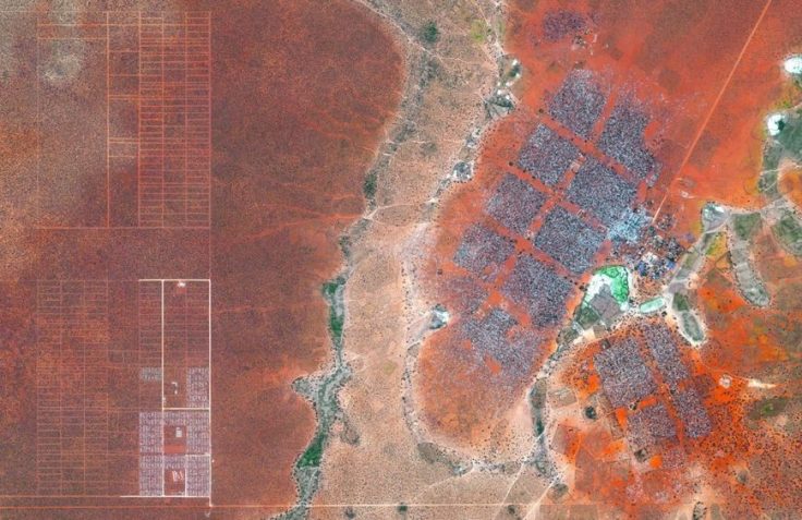
Hagadera, seen here on the right, is the largest section of the Dadaab Refugee Camp in Northern Kenya and is home to 100,000 refugees. To cope with the growing number of displaced Somalis arriving at Dadaab, the UN has begun moving people into a new area called the LFO extension, seen here on the left. Dadaab is the largest refugee camp in the world with an estimated total population of 400,000.

Source: geoawesomeness.com

The most detailed 3D world model

“How to create a detailed 3D topographic model of the entire Earth? As you could suspect the only feasible way to do it is using satellites. But a regular satellite scan will not be detailed enough to give you a meter-level accuracy. Instead of using a single satellite they’ve launched to an orbit two satellites orbiting next to each other capturing stereoscopic scans of the surface of the Earth (that scan the same areas from slightly different angles). Now this data has been processed into a seamless 3-dimensional world map of unprecedented accuracy of 1 meter. The data and the press release are publicly available.”


Tags: geospatial, images, remote sensing.

Source: geoawesomeness.com

Speaking the “Language” of Spatial Analysis

“Spatial analysis has always been a hallmark of GIS, the ‘numerical recipes’ which set GIS apart from other forms of computerized visualization and information management. With GIS we pose questions and derive results using a wide array of analytical tools to help us understand and compare places, determine how places are related, find the best locations and paths, detect and quantify patterns, and even to make spatial predictions.”

Source: blogs.esri.com

GIS is a key tool in spatial analysis, but it can also be a driving force in using math, science, technology and (yes) geography as interdisciplinary ways of teaching the curriculum.  StoryMaps can be rich with images and videos, but also filled with data at a variety of scales.  ESRI has share a “Maps we love” page with excellent examples of Story Maps and carefully explains WHY these maps work and HOW they were made.  Are you new to using the Analysis tool in ArcGIS Online?  Try this exercise on analyzing flood risk to guide you through some of the steps to learn what is possible for a project of your own.  What stories can you tell in this rich, visual format?  What visual template shown might lend itself best for that sort of project? 


Tagsmapping, GISESRIgeography education, geospatial, edtech.

Drones and Geospatial Data

Without sophisticated sensor packages, drones would just be expensive RC airplanes. In this video, Avweb looks at some of the things they can carry.

Source: www.youtube.com

This video gets deep into the specs of sensor packages and the commercial side of UAVs (unmanned aerial vehicles), but it shows how emerging technologies are using and creating geographic data.  This is also a reminder that geography can be incredibly useful in a diverse range of economic sectors and has far-reaching applications in the real world–geography can be incredibly cutting edge.      


Tags: geospatial, video, technology.

All Maps Are Biased. Google Maps’ New Redesign Doesn’t Hide It.

“Google rolled out its new Maps design…from a navigational tool to a commercial interface and offers the clearest proof yet that the geographic web—despite its aspirations to universality—is a deeply subjective entity.”

Source: www.slate.com

Google Maps was updated over the summer, and the updates don’t make them more impartial, but that isn’t a bad thing.  Google Maps now highlight ‘Areas of interest,’ which are created with algorithms designed to reveal the “highest concentration of restaurants, bars, and shops.” The algorithms aren’t ‘objective,’ but are fine-tuned by human engineers to reflect what they consider ‘Areas of Interests’ should look like.  Maps are never as objective as they appear to be, and that can often be a great thing. 


Tags: google, mapping, geospatial, cartography, visualization.

Petra, Jordan: Huge monument found ‘hiding in plain sight’

“Two archaeologists, who recently published their findings in the American Schools of Oriental Research, used Google Earth satellite images and drone photography to identify the outline of an enormous monument buried beneath sand and time at the UNESCO World Heritage site in Jordan.”  —Motherboard

Source: www.bbc.com

When in the Mexican state of Veracruz as a grad student, I saw a startling mountain covered by the dense tropical rain forest; this mountain had a consistent slope with hard angles.  I was awestruck to realize that it was an uncovered (but not undiscovered) pyramid and I wondered just how many archeological sites are waiting to be unearthed. 


Why is a geographer an important member of an interdisciplinary team? This discovery shows that spatial thinking, geographic tools, and a keen eye for usually patterns in unexpected places are critical for many disciplines and fields of research.


Tags: spatial, remote sensing, geospatial, MiddleEast, Jordan, googleunit 1 GeoPrinciples.  

What’s New in ArcGIS Online

“ArcGIS Online has just been updated (June 2016) with the following new features and enhancements. This release includes updates and new capabilities for smart mapping, item pages, improvements to the map viewer and scene viewer, updated content, and more. For additional details see the what’s new help topic.”


TagsmappinggeospatialESRI, edtech.

Source: blogs.esri.com

GeoInquiries – Grade 4 Interdisciplinary

“GeoInquiries are designed to be fast and easy-to-use instructional resources that incorporate advanced web mapping technology. Each 15-minute activity in a collection is intended to be presented by the instructor from a single computer/projector classroom arrangement. No installation, fees, or logins are necessary to use these materials and software.

The Elementary, Grade 4 GeoInquiry collection is under-development.

Source: edcommunity.esri.com

ESRI has produced GeoInquires for Earth Science, US History, Environmental Science, AP Human Geography, and has just recently released an interdisciplinary set of GeoInquiries designed for fourth graders.     These include:

TagsmappinggeospatialESRI, K12, edtech.

VIDEO: Saving the art of mapmaking

“If you’re heading out on the road for your vacation this year, you’ll probably get directions from a GPS or navigational system. Does that mean that the traditional map is a relic of the past? Mark Albert hits the road to find out.”

Source: www.cbsnews.com

This video is designed for a general news audience and it nicely shows the public how cartography is not rendered unimportant in the era of digital maps, but has become all the more useful.  I could see this video as useful resource to share with parents who are worried that studying geography won’t lead to careers.  


Tags: GIS, video, mapping, cartography, geospatial, technology.

Blog at WordPress.com.

Up ↑