Search

GEOGRAPHY EDUCATION

Supporting geography educators everywhere with current digital resources.

Tag

urban

Transportation and Planning

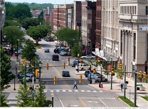
“When you combine a street and a road, you get a STROAD, one of the most dangerous and unproductive human environments. To get more for our transportation dollar, America needs an active policy of converting STROADs to productive streets or high capacity roadways.”

Seth Dixon‘s insight:

In this video, a road provides high connectivity between places, and a street is a diverse platform of social interactions that create a place.  A ‘stroad’ can be likened unto a spork–it tries to do it everything but does nothing especially well.  While you may debate the principle being shown, this video (found on Atlantic Cities) is a good way to show the spatial thinking that city planners need to utilize to improve the urban environment. 

See on www.youtube.com

Flexible Urban Planning

mixed used train-tracks/market place…

I’ve used similar videos in my classes and students are usually quite shocked to see how a city like Bangkok, Thailand operates.  I’ve used this as a ‘hook’ for lessons of population growth, urbanization, economic development, sustainability, megacities and city planning.

See on Scoop.itGeography Education

See on www.youtube.com

Cities where homebuying is most (and least) affordable

See on Scoop.itGeography Education

Looking for an affordable home? Here are 5 cities that are good bets, and 5 cities where owning is tough.

This is an intriguing set of lists.  What geographic factors explain why some cities are on either of these lists?  In related news on housing in the United States, many of the so-called “McMansions” of the 1990s and 2000s were virtually unsellable during the height of the recession.  They are now being sold, but for around half of what they were selling for at their peak.

See on money.cnn.com

What March Madness Can Teach Us About the Economic Geography of Sports

Via Scoop.itGeography Education

The Atlantic Cities:  What exactly can account for the dominance of small and medium sized metros generally and college towns in particular in the economic…

While it is clear that superstar athletes in the professional ranks are concentrated in the largest cities, college athletics still let’s the ‘Davids’ compete with the ‘Goliaths.’  Interestingly, the largest cities don’t have the highest per capita concentration of athletes but many small college towns do.  Among the Top 25 cities with the highest concentration of athletes in the workforce (include scholarship athletes) we find South Bend, Indiana, home to Notre Dame; Auburn, Alabama, home to the university that bears its name; Ames, Iowa, home of Iowa State; Blacksburg, Virginia (Virginia Tech); Burlington, Vermont (University of Vermont); and Boulder, Colorado (University of Colorado).
Via www.theatlanticcities.com

Google Earth in China

Via Scoop.itGeography Education

This gallery of Google Earth Screen shots primarily from Yunnan Province in Southern China (bordering Vietnam and Burma) brings some keen spatial analysis to those unfamiliar with the region.  This is also a great example of using geospatial technologies to interpret the cultural landscape–the merger of ‘people and pixels’ as the textbook of the same name encourages with classrooms.  While the quality of this work is above what would be expected of students, a Google Earth project designed to get students to reassess the spatial dynamics within their neighborhood or home state could lead some fantastic projects.
Via www.facebook.com

Create a free website or blog at WordPress.com.

Up ↑