Search

GEOGRAPHY EDUCATION

Supporting geography educators everywhere with current digital resources.

Author

sethdixon

I am a geography professor at Rhode Island College.

Re-examining the Battle of Gettysburg with GIS

“GIS has given us the chance to re-examine how the Civil War battle was won and lost.”

Seth Dixon‘s insight:

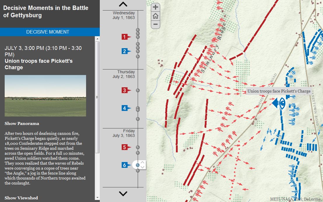
July 1-3 mark the 150th anniversary of the Battle of Gettysburg, and it seems only appropriate to share these rich, interactive resources to commemorate the event (this particular interactive feature uses an ESRI storymap template).  This is a fantastic example from the Smithsonian Magazine of how history teaching and research can be benefitted by using GIS with the example of Gettysburg.  Many student today visit the sites of the Battle of Gettysburg and get a greater appeciation of battle by getting a sense of the lay of the land and the  challenged confronting both armies.  National Geographic has additionally put together resources to made out other Civil War battles.  GIS is not a tool that is just for geographers; any analysis that requires spatial analysis can be mapped. 

Tags: historicalwar, landscape, spatial, GIS, ESRI.

See on www.smithsonianmag.com

Gettysburg

Why these Somali refugees do not want to leave Kenya

“For millions of refugees across Africa life is a daily struggle.  Many dream of one day returning to their homeland while others have spent decades building a new life.  On World Refugee Day, BBC Focus on Africa’s Anne Soy visits a Somali family in Nairobi, Kenya, who cannot imagine returning to their roots.”

Seth Dixon‘s insight:

Questions to Ponder: Is it the duty of a refugee to return to their home country as soon as it safe?  If you were a refugee, what geographic factors (economic, cultural, political, environmental) would shape you decisions to stay or return?

Tags: refugees, migration, Somalia, Africa,

See on www.bbc.co.uk

Stamen Maps

“Stamen’s toner, terrain and watercolor map styles are lovingly crafted and free for the taking.”

Seth Dixon‘s insight:

With all the feel of an old, hand-drawn maps, this watercolor map layer is designed to wash out rough edges and makes a map with current road layers still feel like a vintage map.  Compare and constrast with the toner and terrain layouts. 

Tags: mapping, cartographyart.

See on maps.stamen.com

Words Matter: How Geospatial Education Suffers Because of Government Classification

“Recent news stories discussed why geography is important to an informed and engaged society.  To those of us in the geospatial profession, basic geography education is an essential foundation to encouraging young people to enter the workforce in surveying, photogrammetry, GIS and other disciplines in our field.”

Seth Dixon‘s insight:

While many in the geography education business bemoan student’s lack of global awareness as a rationale for geography education, this is the key angle that I feel we should be pushing: the workforce.  We currently are not producing enough students with geospatial skills in the United States to fill the jobs (one of the problems with geography being classified as a social science).  Now that is a practical reason to support geography that non-geographers can understand.

Tags: labor, geospatial, edtech, geography education,

See on www.pobonline.com

Bike Share Map

Visualisation for bike shares across the world.

Seth Dixon‘s insight:

Many cities (including Denver) have active bike share programs to ease congestion and foster a less automobile-centric urban design.  London, Paris and Mexico City are a handful of the international cities listed here but it isn’t only the largest cities (Hello Lillestrøm, Norway!).  In the U.S., it is the same with typical cities (NYC and Washington DC) as well as as some smaller cities (Chattanooga and Omaha).  Is your city on the list

Tags: transportation, urban, planning.

See on bikes.oobrien.com

Map

Seth Dixon‘s insight:

The best technologies aren’t only the newest and the most expensive.  We are often attracted to the latest and greatest and devalue the tried and true practices out there. 

See on www.youtube.com

Choices Program Presentation

What Does Good GeographyTeaching Look Like? Answering the Big Questions in Geography.

Seth Dixon‘s insight:

I’m presenting today at a summer institute entitled, Thinking Geographically About International Issues for The Choices Program (housed at Brown University).  This is a preview for what will be discussed there.    

See on www.slideshare.net

Placing Literature maps book scenes in the real world

Placing Literature maps book scenes in the real world.”

Seth Dixon‘s insight:

This article reviews a great new site, Placing Literature.  Much like Google Lit Trips, this site’s goal is to make geography come alive in literature.  Given that this site is still in its infancy, there are few novels and places in the system, but I don’t see that as a drawback.  I see this as a fantastic platform for a student project where they could make a significant online contribution.

See on news.cnet.com

Visualizing 3 Billion Tweets

This is a look at 3 billion tweets – every geotagged tweet since September 2011, mapped, showing facets of Twitter’s ecosystem and userbase in incredible new detail, revealing demographic, cultural, and social patterns down to city level detail, across the entire world.

Seth Dixon‘s insight:

In this this great social media dataset, patterns of population density are immediately evident, with areas with great population densities not surprisingly representing the greatest concentration of social media usage.  On closer inspection though, the major transportation arteries (or in this particular map map of NYC, tourism districts) become much more visible than a population density map would suggest.  


Tags: visualizationsocial media, transportation, globalization, mapping, NYC, tourism.

See on www.mapbox.com

Create a free website or blog at WordPress.com.

Up ↑