Search

GEOGRAPHY EDUCATION

Supporting geography educators everywhere with current digital resources.

Author

sethdixon

I am a geography professor at Rhode Island College.

The countries most at risk for a coup in 2013

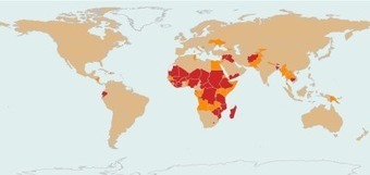
“The map [above] sorts the countries of the world into three groups based on their relative coup risk for 2013: highest (red), moderate (orange), and lowest (beige).”

Seth Dixon, Ph.D.‘s insight:

While this is not predicting a coup in any of these places, this map is a visualization of data that was used to assess the factors that would make a coup likely (to see an alternate map, here is the Washington Post’s review of the same data that mapped the 30 countries most likely to have a coup). 


Questions to Ponder: What factors do you think would be important in compilling data of this nature?  What makes a country susceptible to this type of governmental overthrow?  What creates governmental stability? 

Tags: political, conflict, unit 4 political, governance, Africa.

See on dartthrowingchimp.wordpress.com

Historical Interactive Topographic Map of Switzerland


Seth Dixon, Ph.D.‘s insight:

This is an excellent interactive topographic map of Switzerland with great detail at a variety of scales and historical images from 1938 to the present.

See on map.swisstopo.admin.ch

Mount Dixon Explodes!

An initial analysis of the Mount Dixon landslide in New Zealand on Monday

Seth Dixon, Ph.D.‘s insight:

There are some great images (and a post-landslide helicopter flight video) of the massive landslide that occurred Jan 21, 2013.  The rockslide extends over 3 km, with an elevation change of approximately 800 meters.  This is an excellent example to help students visualize mass wasting, alpine glaciation and erosion in general.  While the mountain didn’t explode strictly speaking, I couldn’t help but love the headline “Mount Dixon explodes!”    

Tags: New Zealand, physical, geomorphology, erosion.

See on blogs.agu.org

Refugees from Syria

The number of Syrian refugees who have fled the conflict and crossed the borders hasn’t ceased to increase.

Seth Dixon, Ph.D.‘s insight:

UNICEF workers have stated: “More than 600,000 have fled the conflict in Syria and registered as refugees. The number of Syrians who have left without registering is unknown but is likely to be hundreds of thousands. We do know, however, that children make up around half the number of refugees and that is certainly no way for any child to live their childhood.”

Tags: Syria, conflict, political, MiddleEast, war.

See on visual.ly

Let elderly people ‘hurry up and die’, says Japanese minister

Taro Aso says he would refuse end-of-life care and would ‘feel bad’ knowing treatment was paid for by government

Seth Dixon, Ph.D.‘s insight:

It’s no secret that Japan’s population is aging and can not replace itself.  Since it is not a destination country for migrants, this is going to have serious economic ramifications as the percentage of the Japanese population over 60 is expected to rise above 40% over the course of this next generation.  Given the harsh statements by the new Japanese finance minister, it’s a huge political concern (although a difficult one mention in campaigns).  Some have already questioned Japan’s ability to survive this demographic implosion as adult diapers are now a bigger moneymaker in Japan than children’s diapers.


Tags: Japan, declining population, economic, population, demographics, unit 2 population, East Asia.

See on www.guardian.co.uk

Russian Orthodox believers celebrate Epiphany with an icy plunge

Thousands of members of the Russian Orthodox Church marked Epiphany on January 19 with a dip in freezing waters blessed by a cleric. Epiphany is a celebration of the baptism of Jesus Christ and the…

Seth Dixon, Ph.D.‘s insight:

Some of the photography and photo galleries of this cultural event are breathtaking–literally for those taking the plunge.  Russians cut the ice in the shape of a cross and bath in water that is blessed and considered holy.  This appears to be a religious tradition that is particularly adapted to the environmental conditions of the religious adherents (since it appears that the extreme climate plays a critical role in the activity).  Part of the practice involves sacrifice; the colder the swim, the greater the manifestation of religious devotion.    

Tags: Russia, religion, culture

See on blogs.pjstar.com

Interactive: Mapping the World’s Friendships

Technology bridges distance and borders. Individuals today can keep in touch with their friends and family in completely new ways — regardless of where they live. We explored these internatio…

People can be digitally connected with anyone around the world these days, without any limitations by distance or culture.  Yet, by analyzing peoples social networks, it is clear that geographic factors are still a crucial factor in mediating our scoial interactions.  The internet can, but doesn’t fully conquer space.    

Tags: socialmedia, worldwide, mapping

See on www.facebookstories.com

Census Data Mapper

“This web mapping application provides users with a simple interface to view, customize, save and print thematic maps of the United States, using data from the 2010 Census.  The beta version contains a set of 2010 Census data relating to age and sex, population and race, and family and housing in the United States by county or equivalent entity.” 

Seth Dixon, Ph.D.‘s insight:

This month the U.S. Census Bureau has released the beta version of a very nice online mapping tool to display the 2010 data.  The mapper will create PDF versions of any map produced online (file sizes from 20-55KB) and the user can export the raw data to Excel.  While the user is more limited in how to display the data than they would using a GIS, this is a simple way to explore some of the basic census information.

Tags: statistics, census, GIS, mapping, cartography.

See on www.census.gov

The California-Mexico Border: Dreams of a Transnational Metropolis

“A basic truth about the cultural geography of the California border [is this]—two very different city-building traditions come crashing into each other at one of the most contentious international boundary lines on the planet. In this collision, in the shocking contrast of landscapes, lies one critical ingredient of the border’s place identity.”

Seth Dixon, Ph.D.‘s insight:

As a geographer native to the San Diego region (with family on both sides of the border), I found this article very compelling.  Relations across the border are economic, cultural and political in nature, and the merger of those varied interests have led to an uneven history of both cooperation and separation.  Herzog analyses three distinct factors that have shape the landscape of the California-Mexico border zone: urbanization, NAFTA, and global interruptions (9/11).    

Tags: borders, AAG, political, landscape, California, unit 4 political, Mexico.

See on www.aag.org

tijuanavistapanoramicadetijuan

Blog at WordPress.com.

Up ↑