Search

GEOGRAPHY EDUCATION

Supporting geography educators everywhere with current digital resources.

Author

sethdixon

I am a geography professor at Rhode Island College.

Adaptive Roots in the Concrete Jungle

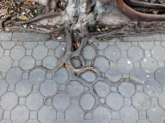
In this fantastic sighting by photographer Horst Kiechle, we see the roots of a tree in Bangkok, Thailand (Lat Yao, Chatuchak to be exact) growing into the grooves and cracks of an interlocking sidewalk. Even the colour of the roots gradually fade into the pavement.

Seth Dixon, Ph.D.‘s insight:

This startling image is a powerful testament to the adaptive nature of many species to the urban environment.  Some species will adapt in beautiful ways such as this tree, while other will adapt is ways that go against our plan for that urban space (think rats, pigeons and cockroaches).  We adapt to our environment and the environment adapts to us as well; but that relationship is not always peaceful and symbiotic.  We can also destroy ecosystems that are fragile and not as resilient to change as this tree is.  See this same tree’s root network one year later


Tags: urban ecology, environment adapt, sustainability, biogeography.

See on twistedsifter.com

A Layman’s Geography Guide to the Most Confusing Region Of the World: Iran

Iran’s geography plays heavily in the foreign affairs issues it is a part of, and the policies it makes.


Seth Dixon, Ph.D.‘s insight:

“Iran sits smack in the middle of one of the most important geopolitical regions on Earth. Much of its western flank is bordered by either Iraq or the Persian Gulf, and it has considerable control over one of the world’s most important waterways for oil shipping and trade, the Strait of Hormuz.” 


Given it’s context, Iran is a country that students should know beyond the three main facts that that most Americans are aware of (Iran has an Islamic-based government, an emerging nuclear program and a ton of oil).  This article is a good starting point. 


Tags: Iran, political, Middle East.

See on www.policymic.com

Google releases detailed map of North Korea, gulags and all

Google Maps rolls out a detailed may of the secretive state.

Seth Dixon, Ph.D.‘s insight:

Citizen cartographers have edited Google’s North Korea map, putting information on what was previously an absence of data concerning one of the most secretive countries in the world.  In essence, as explained in this video, Google is crowd-sourcing the map.  How might this geographic knowledge change our perception of North Korea?  How might the dissemination of this information affect North Korea?  

 Tags: North Korea, mapping, cartography.

See on www.washingtonpost.com

Can Textbooks Ever Really Be Free?

Many agree that making books free for college students is a good idea. But nobody’s found a great way to do it.

Seth Dixon, Ph.D.‘s insight:

This can work if authors and publishers walk away from a lucrative industry…(I’m not holding my breath).  As long as there is money to be made and until the highest quality textbooks in the field are free, there won’t be a major changes in the industry.  Personally though, I LOVE the idea.   

See on chronicle.com

France bans popular English expressions

France declares war on the English language. Erin Burnett reports….

Seth Dixon, Ph.D.‘s insight:

France is famous for trying to slow the linguistic diffusion of globalization’s most powerful online language (which also happens to belong to their age-old cultural and political rival).  France has a commission dedicated to removing new words that have English origins with one’s that have linguistic roots in French.  Recently then have done away with the Twitter term #hashtag to #mot-dièses.  This video criticizes this cultural practice and it is also derided in this NPR article

However this does not mean that France is immune to cultural pressure to change linguistic traditions.  There was been a movement to alter the term Mademoiselle from official documents with a new title that allows women the freedom to choose the form of address that they prefer (and not to force them to reveal their marital status–think Ms. vs Miss).

Questions to Ponder: Why (and how) do languages change over time?  Is it possible to keep a language ‘pure?’

Tags: language, culture, globalization, unit 3 culture, France.

See on outfront.blogs.cnn.com

WebGL’s Digital Globe

A showcase of creative experiments programmed in JavaScript, HTML5, and WebGL

Seth Dixon, Ph.D.‘s insight:

Pictured above is a still image of an interactive digital globe with population density data with colored bar graphs to symbolize the data.  This is a great open-source platform for geographic data visualization. There are not many data layers currently, but possibly there will be more in the future (best viewed in Google Chrome).  

Tagspopulation, demographics, unit 2 population, visualization, mapping.

See on www.chromeexperiments.com

Feuding Over Food

In the Caucasus, culinary nationalism is an extension of the region’s long-simmering disputes.

Seth Dixon, Ph.D.‘s insight:

“There is perhaps nothing more closely bound up with one’s national identity than food. Specific local dishes are often seen as the embodiment of various cultures and many nations promote their food as a celebration of national identity. Sometimes, however, a country’s cuisine can also be used to highlight national rivalries.” 

This opening paragraph nicely shows how cultural traditions from a similar cultural hearth may have much in common.  However, since these groups are neighbors, the geopolitical relationship may be strained despite the cultural commonalities. 

Tags: food, culture, unit 3 culture.

See on www.theatlantic.com

Creating American Borders

30-second animation of the changes in U.S. historical county boundaries, 1629 – 2000. Historical state and territorial boundaries are also displayed from 178…

Seth Dixon, Ph.D.‘s insight:

I love this time-lapse animation of all the county and state-level boundary changes in United States history.  Would you like to see this in greater detail?  Would you want to download the data and create your own visualization of this?  The Atlas of Historical County Boundaries has all of this data as GIS shapefiles, Google Earth KMZ files and PDFs for the whole country as well as for each individual state.  This project sponsored by The Newberry and the National Endowment for the Humanities has tremendous potential for use in the classroom for history and geography teachers alike.  

Tags: historical, USA, borders, time lapse, mapping, edtech.

BorderMap

Rio’s shantytowns are finding a place on city maps

RIO DE JANEIRO — Look at most maps of Rio de Janeiro. The beaches are easy to spot, as are the iconic ocean-front neighborhoods of Copacabana and Ipanema. In the middle is a vast forest.

Seth Dixon, Ph.D.‘s insight:

A nonprofit organization run by current and former favela residents called Redes da Mare has started the first mapping program to systematically chart our the favelas for municipal governments.  We take for granted what having an address on a named street means in a modern society; it is a portal to public utilities, recognition with businesses and countless other social benefits.  Being left ‘off the map’ is synonymous with being left behind.  By finding their way on the city maps they are removing some of the social stigma that sought to treat them as if they did not exist.  


Tags: Brazil, urban, squatter, mapping

See on www.washingtonpost.com

Create a free website or blog at WordPress.com.

Up ↑