“Mont Saint-Michel emerges from the tides in Normandy, France, like an ancient village from a fairytale. The coastal town built on a massive granite rock cuts a dramatic silhouette against the sky, rising from disappearing marshes to a Gothic Abbey at its height. With a permanent population of around 50, this popular tourist destination has a history dating back to at least the Roman era. Fancy a tour before the tides roll in?”
Coastal physical geography produces some beautiful landforms such as tombolos. A tombolo is created when sand deposits attach an island to a larger piece of land–think of it as special type of isthmus. Mont St. Michel is the world’s most famous example because of the iconic walled city with crowned with a striking medieval abbey. This is one of those fascinating places for both the human and physical geographer.
The United States is already taking some steps to roll back the Islamic State (ISIS) and restrict its resources and recruits, including airstrikes, armin
This is a non-partisan post and a video that is fairly balanced; this video nicely lays out some of the cultural and political factors that the next president of the United States should consider when crafting foreign policy in the especially problematic Middle East.
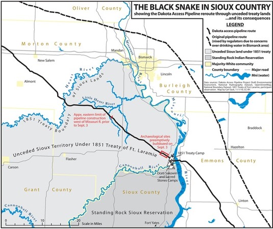
“Thousands of Native Americans and their allies have gathered on unceded Sioux land delimited by the 1851 Treaty of Fort Laramie to try and stand in the way of the “black snake” that could poison the Standing Rock Reservation’s water supply. Many have noted that the pipeline corridor was repositioned from its original route north of Bismarck after white citizens spoke up against the threat a spill would pose to their drinking water ― a threat duly recognized by the U.S. Army Corps of Engineers. Yet the Corps failed its federal mandate for meaningful consultation with the Standing Rock Tribe before signing off on a route that moved the pipeline to their doorstep.”
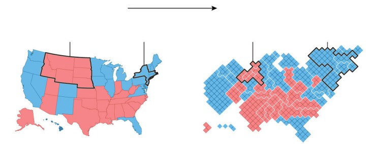
Maps can tell truths, and maps can be used to obscure other truths. Creating a map, choosing what data to include (and exclude) is an inherently political act. Maps have the power to convey geographic perspectives that might otherwise be muted.
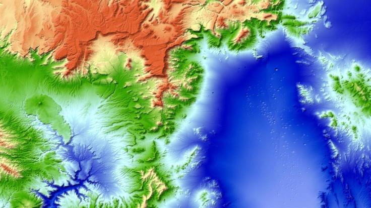
“How to create a detailed 3D topographic model of the entire Earth? As you could suspect the only feasible way to do it is using satellites. But a regular satellite scan will not be detailed enough to give you a meter-level accuracy. Instead of using a single satellite they’ve launched to an orbit two satellites orbiting next to each other capturing stereoscopic scans of the surface of the Earth (that scan the same areas from slightly different angles). Now this data has been processed into a seamless 3-dimensional world map of unprecedented accuracy of 1 meter. The data and the press release are publicly available.”
This is nothing new to most visitors to this site, but every four years we have a wonderful teaching moment to show how population density can change our interpretation of a map and the meaning of the data embedded in that map. I preparation for next week, this article for the Washington Post as well as this one from the New York Times should help get students be better prepared for the onslaught of maps that we know are right around the corner, to properly assess and contextualize the geographic content in these maps.
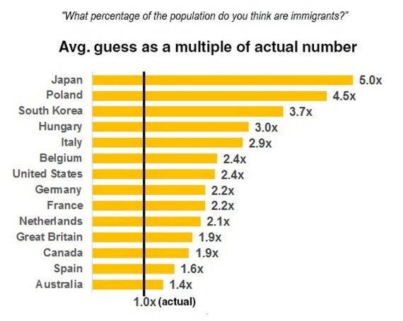
In developed countries around the world, people think immigrant populations are much larger than they actually are.
Americans consistently mention immigration as one of the nation’s most pressing political concerns, and it has become a signature issue in the presidential campaign. But while many Americans consider immigration one of the biggest issues for the future president, surveys suggest that they also have little understanding of the scale of the problem. The United States wasn’t alone in this tendency to exaggerate.
“Diwali, one of the biggest holidays in Indian culture, is a five-day festival of lights celebrated worldwide by Hindus, Sikhs and Jains. This year, the traditional day of Diwali falls on Oct. 30, though celebrations span the entire week leading up to and following the holiday, which marks the triumph of good over evil.”